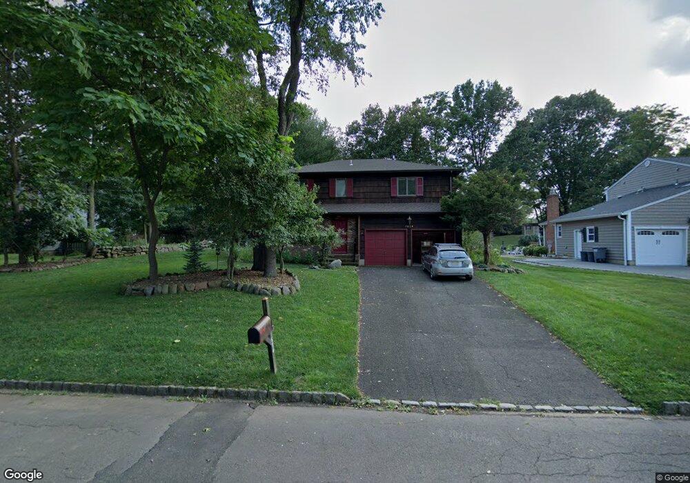
1674 Frank St Scotch Plains, NJ 07076
Estimated Value: $621,785 - $1,301,000
--
Bed
--
Bath
2,216
Sq Ft
$459/Sq Ft
Est. Value
About This Home
This home is located at 1674 Frank St, Scotch Plains, NJ 07076 and is currently estimated at $1,017,196, approximately $459 per square foot. 1674 Frank St is a home located in Union County with nearby schools including J. Ackerman Coles Elementary School, Terrill Middle School, and Scotch Plains-Fanwood High School.
Ownership History
Date
Name
Owned For
Owner Type
Purchase Details
Closed on
May 28, 1997
Sold by
Shea Gerald A and Shea Lois M
Bought by
Shea Lois M
Current Estimated Value
Home Financials for this Owner
Home Financials are based on the most recent Mortgage that was taken out on this home.
Original Mortgage
$110,000
Outstanding Balance
$15,727
Interest Rate
7.97%
Estimated Equity
$1,001,469
Create a Home Valuation Report for This Property
The Home Valuation Report is an in-depth analysis detailing your home's value as well as a comparison with similar homes in the area
Home Values in the Area
Average Home Value in this Area
Purchase History
| Date | Buyer | Sale Price | Title Company |
|---|---|---|---|
| Shea Lois M | $88,437 | -- |
Source: Public Records
Mortgage History
| Date | Status | Borrower | Loan Amount |
|---|---|---|---|
| Open | Shea Lois M | $110,000 |
Source: Public Records
Tax History Compared to Growth
Tax History
| Year | Tax Paid | Tax Assessment Tax Assessment Total Assessment is a certain percentage of the fair market value that is determined by local assessors to be the total taxable value of land and additions on the property. | Land | Improvement |
|---|---|---|---|---|
| 2025 | $15,522 | $131,900 | $25,200 | $106,700 |
| 2024 | $15,064 | $131,900 | $25,200 | $106,700 |
| 2023 | $15,064 | $131,900 | $25,200 | $106,700 |
| 2022 | $14,885 | $131,900 | $25,200 | $106,700 |
| 2021 | $14,860 | $131,900 | $25,200 | $106,700 |
| 2020 | $14,789 | $131,900 | $25,200 | $106,700 |
| 2019 | $14,679 | $131,900 | $25,200 | $106,700 |
| 2018 | $14,433 | $131,900 | $25,200 | $106,700 |
| 2017 | $14,112 | $131,900 | $25,200 | $106,700 |
| 2016 | $13,840 | $131,900 | $25,200 | $106,700 |
| 2015 | $13,613 | $131,900 | $25,200 | $106,700 |
| 2014 | $13,165 | $131,900 | $25,200 | $106,700 |
Source: Public Records
Map
Nearby Homes
- 1535 Frank St
- 980 Raritan Rd
- 1691 Frank St
- 21 King St
- 8 Mary Ellen Dr
- 4 Hemlock Dr
- 5 Old Raritan Rd
- 11 Madaline Dr
- 3 Old Hickory Ln
- 145 Maplewood Ct Unit 145D
- 31 Hickory Hollow Ct
- 166 Hidden Hollow Ct
- 19 Ravenswood Ln
- 221 Golf Ave E
- 2715 Maple Ave
- 1454 S End Pkwy Unit 56
- 404 Westgate Dr
- 154 Westgate Dr
- 302 Westgate Dr
- 338 Westgate Dr Unit 338