168 Old Newton Rd N Lagrange, GA 30240
Estimated Value: $564,000 - $881,298
4
Beds
5
Baths
5,156
Sq Ft
$143/Sq Ft
Est. Value
About This Home
This home is located at 168 Old Newton Rd N, Lagrange, GA 30240 and is currently estimated at $735,766, approximately $142 per square foot. 168 Old Newton Rd N is a home located in Troup County with nearby schools including Long Cane Elementary School, Berta Weathersbee Elementary School, and Whitesville Road Elementary School.
Ownership History
Date
Name
Owned For
Owner Type
Purchase Details
Closed on
Aug 20, 1998
Sold by
Chas Smith
Bought by
Smith Charles W
Current Estimated Value
Purchase Details
Closed on
Aug 19, 1998
Sold by
John Stewart
Bought by
Chas Smith
Purchase Details
Closed on
Aug 6, 1998
Sold by
Chas Smith
Bought by
John Stewart
Purchase Details
Closed on
Dec 22, 1986
Sold by
John W Stewart
Bought by
Chas Smith
Purchase Details
Closed on
Sep 12, 1977
Sold by
James A Newton
Bought by
John W Stewart
Purchase Details
Closed on
Aug 23, 1977
Sold by
Mrs Jimmie F Newton Bennett
Bought by
James A Newton
Create a Home Valuation Report for This Property
The Home Valuation Report is an in-depth analysis detailing your home's value as well as a comparison with similar homes in the area
Home Values in the Area
Average Home Value in this Area
Purchase History
| Date | Buyer | Sale Price | Title Company |
|---|---|---|---|
| Smith Charles W | -- | -- | |
| Chas Smith | -- | -- | |
| John Stewart | -- | -- | |
| Chas Smith | $30,000 | -- | |
| John W Stewart | $11,500 | -- | |
| James A Newton | -- | -- |
Source: Public Records
Tax History Compared to Growth
Tax History
| Year | Tax Paid | Tax Assessment Tax Assessment Total Assessment is a certain percentage of the fair market value that is determined by local assessors to be the total taxable value of land and additions on the property. | Land | Improvement |
|---|---|---|---|---|
| 2024 | $8,248 | $304,400 | $24,360 | $280,040 |
| 2023 | $8,017 | $295,960 | $24,360 | $271,600 |
| 2022 | $7,623 | $275,120 | $24,360 | $250,760 |
| 2021 | $7,610 | $254,320 | $10,320 | $244,000 |
| 2020 | $7,610 | $254,320 | $10,320 | $244,000 |
| 2019 | $7,190 | $240,400 | $10,320 | $230,080 |
| 2018 | $6,796 | $227,320 | $10,320 | $217,000 |
| 2017 | $6,796 | $227,320 | $10,320 | $217,000 |
| 2016 | $6,511 | $217,869 | $10,335 | $207,534 |
| 2015 | $6,679 | $223,055 | $10,335 | $212,720 |
| 2014 | $6,690 | $223,055 | $10,335 | $212,720 |
| 2013 | -- | $223,055 | $10,335 | $212,720 |
Source: Public Records
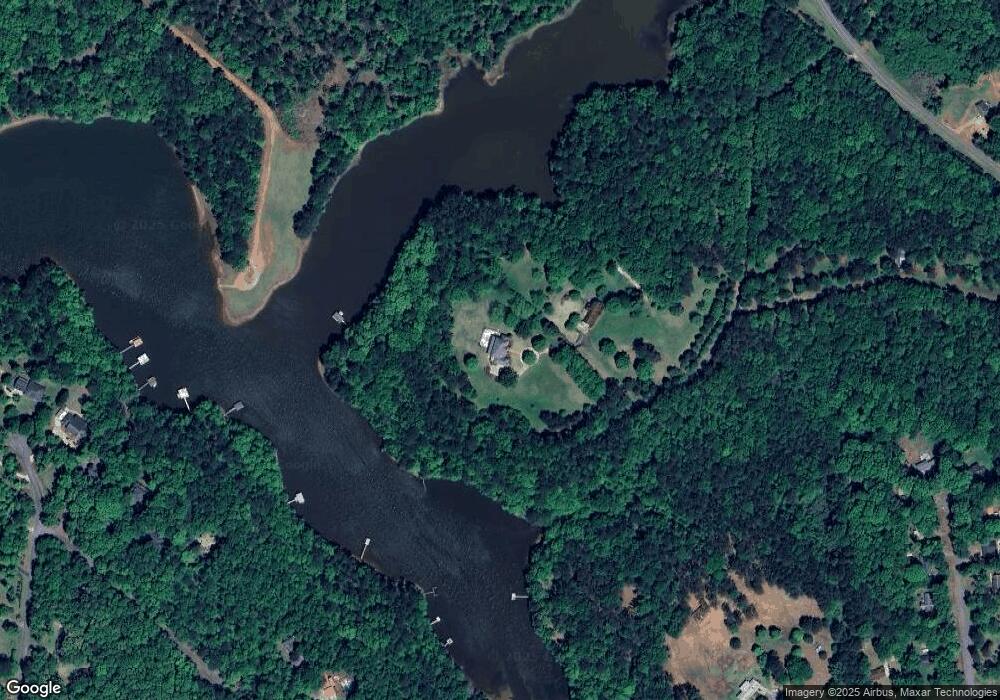
Map
Nearby Homes
- 40 River Point Dr
- 474 Newton Rd
- 101 Ivy Springs Dr
- 119 Plymouth Dr
- 102 Franklin Place
- 135 Planters Ridge Dr
- 0 Deming St Unit 10550189
- 102 Foxdale Dr
- 226 Linda Ln
- 108 Hidden Springs Dr
- 709 Vernon Ferry Rd
- 124 Foxdale Dr
- 103 Dogwood Ct
- 104 Dogwood Point
- 114 Riverbluff Dr
- 110 Hawthorne Cir
- 106 Landings Way
- 104 Landings Way
- 201 Lakeview Ct
- 103 Hawthorne Cir
- 166 Old Newton Rd N
- 0 Old Newton Rd S Unit 7058297
- 167 N Old Newton Rd N
- 49 Post Oak Dr
- 73 Post Oak Dr
- 83 Post Oak Dr
- 29 Post Oak Dr
- 31 Post Oak Dr
- 116 Wilson Creek Dr
- 109 Heatherbrook Dr
- 111 Heatherbrook Dr
- 5 Post Oak Dr
- 244 River Point Dr
- 244 River Point Dr Unit 9
- 120 Wilson Creek Dr
- 114 Wilson Creek Dr
- 105 Heatherbrook Dr
- 122 Wilson Creek Dr Unit 17
- 110 Heatherbrook Dr
- 208 Newton Rd