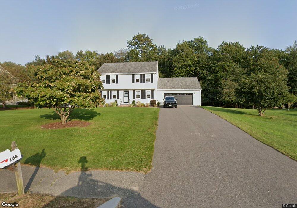
168 Presidential Dr Abington, MA 02351
Estimated Value: $577,000 - $880,000
3
Beds
2
Baths
1,700
Sq Ft
$423/Sq Ft
Est. Value
About This Home
This home is located at 168 Presidential Dr, Abington, MA 02351 and is currently estimated at $718,392, approximately $422 per square foot. 168 Presidential Dr is a home located in Plymouth County with nearby schools including Woodsdale School, Beaver Brook Elementary School, and Abington Middle School.
Ownership History
Date
Name
Owned For
Owner Type
Purchase Details
Closed on
Nov 11, 2024
Sold by
Pasquale Richard J and Pasquale Dorothy A
Bought by
Pasquale Michael R
Current Estimated Value
Purchase Details
Closed on
Apr 22, 1988
Sold by
Abington Dev Corp
Bought by
Pasquale Richard J
Home Financials for this Owner
Home Financials are based on the most recent Mortgage that was taken out on this home.
Original Mortgage
$85,000
Interest Rate
9.89%
Mortgage Type
Purchase Money Mortgage
Create a Home Valuation Report for This Property
The Home Valuation Report is an in-depth analysis detailing your home's value as well as a comparison with similar homes in the area
Home Values in the Area
Average Home Value in this Area
Purchase History
| Date | Buyer | Sale Price | Title Company |
|---|---|---|---|
| Pasquale Michael R | -- | None Available | |
| Pasquale Michael R | -- | None Available | |
| Pasquale Richard J | $224,900 | -- |
Source: Public Records
Mortgage History
| Date | Status | Borrower | Loan Amount |
|---|---|---|---|
| Previous Owner | Pasquale Richard J | $120,000 | |
| Previous Owner | Pasquale Richard J | $85,000 |
Source: Public Records
Tax History Compared to Growth
Tax History
| Year | Tax Paid | Tax Assessment Tax Assessment Total Assessment is a certain percentage of the fair market value that is determined by local assessors to be the total taxable value of land and additions on the property. | Land | Improvement |
|---|---|---|---|---|
| 2025 | $8,191 | $627,200 | $275,200 | $352,000 |
| 2024 | $8,375 | $625,900 | $284,000 | $341,900 |
| 2023 | $7,571 | $532,800 | $229,600 | $303,200 |
| 2022 | $7,505 | $493,100 | $193,300 | $299,800 |
| 2021 | $7,395 | $448,700 | $207,200 | $241,500 |
| 2020 | $7,031 | $413,600 | $178,400 | $235,200 |
| 2019 | $7,005 | $402,800 | $178,400 | $224,400 |
| 2018 | $6,642 | $372,700 | $178,400 | $194,300 |
| 2017 | $6,586 | $358,900 | $178,400 | $180,500 |
| 2016 | $6,071 | $338,600 | $166,500 | $172,100 |
| 2015 | $5,644 | $332,000 | $166,500 | $165,500 |
Source: Public Records
Map
Nearby Homes
- 23 Loganberry Dr
- 451 Lincoln St
- 10 Mccue Cir
- 47 Daniel Dr
- 715 Thayer St Unit 715
- 840 Hancock St
- 717 Hampton Way
- 221 Chestnut St
- 305 Rembrandt Way Unit 305
- 34 George h Gillespie Way
- 90 Warren St
- 298 N Quincy St
- 21 Maplewood Cir
- 32 Warren St
- 676 Bedford St
- 101 Regency Ln
- 197 Bedford St
- 307 Regency Ln Unit 307
- 5-7 W Chapel St
- 930 Brockton Ave
- 152 Presidential Dr
- 182 Presidential Dr
- 179 Presidential Dr
- 167 Presidential Dr
- 191 Presidential Dr
- 196 Presidential Dr
- 132 Presidential Dr
- 143 Presidential Dr
- 203 Presidential Dr
- 47 Van Buren Dr
- 151 Mckinley Dr
- 61 Van Buren Dr
- 105 Van Buren Dr
- 85 Van Buren Dr
- 215 Presidential Dr
- 118 Mckinley Dr
- 27 Van Buren Dr
- 125 Van Buren Dr
- 214 Presidential Dr
- 121 Presidential Dr