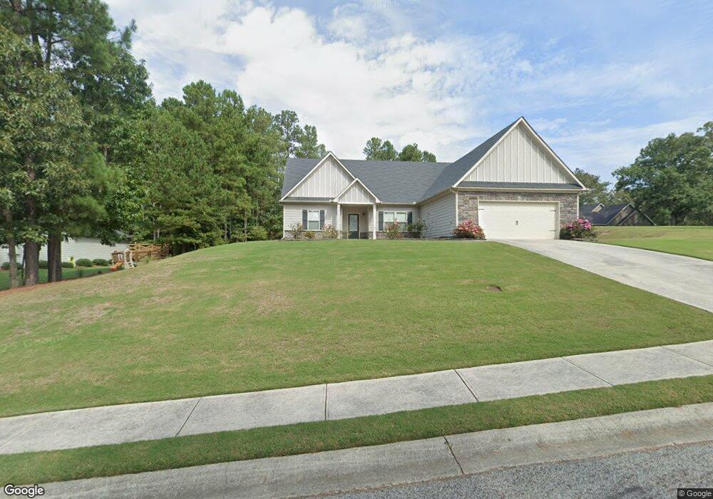
1681 Shadowstone Ct Winder, GA 30680
Estimated Value: $371,267 - $412,000
Studio
1
Bath
1,932
Sq Ft
$206/Sq Ft
Est. Value
About This Home
This home is located at 1681 Shadowstone Ct, Winder, GA 30680 and is currently estimated at $397,567, approximately $205 per square foot. 1681 Shadowstone Ct is a home with nearby schools including Bramlett Elementary School, Russell Middle School, and Winder-Barrow High School.
Ownership History
Date
Name
Owned For
Owner Type
Purchase Details
Closed on
Sep 25, 2015
Sold by
Cook Residential Llc
Bought by
Ciora Victoria
Current Estimated Value
Purchase Details
Closed on
Jun 12, 2015
Sold by
Shadow Stone Partners Llc
Bought by
Cook Residential Llc
Purchase Details
Closed on
Jan 6, 2012
Sold by
Community & Southern Bank
Bought by
Shadow Stone Partners Llc
Purchase Details
Closed on
Jul 15, 2009
Sold by
Vannoy Partners Llc
Bought by
The Peoples Bank
Purchase Details
Closed on
Jun 29, 2006
Sold by
Butler Eddie J And
Bought by
Vannoy Partners Llc
Create a Home Valuation Report for This Property
The Home Valuation Report is an in-depth analysis detailing your home's value as well as a comparison with similar homes in the area
Home Values in the Area
Average Home Value in this Area
Purchase History
| Date | Buyer | Sale Price | Title Company |
|---|---|---|---|
| Ciora Victoria | $179,775 | -- | |
| Cook Residential Llc | -- | -- | |
| Shadow Stone Partners Llc | $187,000 | -- | |
| The Peoples Bank | -- | -- | |
| Vannoy Partners Llc | $4,239,800 | -- |
Source: Public Records
Tax History Compared to Growth
Tax History
| Year | Tax Paid | Tax Assessment Tax Assessment Total Assessment is a certain percentage of the fair market value that is determined by local assessors to be the total taxable value of land and additions on the property. | Land | Improvement |
|---|---|---|---|---|
| 2025 | $1,197 | $141,666 | $32,091 | $109,575 |
| 2024 | $2,202 | $141,666 | $32,091 | $109,575 |
| 2023 | $1,283 | $141,666 | $32,000 | $109,666 |
| 2022 | $1,419 | $102,366 | $24,400 | $77,966 |
| 2021 | $1,201 | $91,664 | $16,800 | $74,864 |
| 2020 | $917 | $82,356 | $16,800 | $65,556 |
| 2019 | $951 | $82,356 | $16,800 | $65,556 |
| 2018 | $932 | $77,325 | $16,800 | $60,525 |
| 2017 | $2,117 | $72,713 | $16,800 | $55,913 |
| 2016 | $730 | $63,453 | $16,800 | $46,653 |
| 2015 | $296 | $7,560 | $7,560 | $0 |
| 2014 | $79 | $2,000 | $2,000 | $0 |
| 2013 | -- | $2,000 | $2,000 | $0 |
Source: Public Records
Map
Nearby Homes
- 2858 Shadowstone Way
- 1557 Shadowstone Cir
- 1303 Windstone Ct
- 817 Brookside Dr
- 1000 Jim Johnson Rd
- 432 Mulberry Rd
- 1072 Jim Johnson Rd
- 852 Georgetown Dr
- 222 Loon Lake Way
- 225 Coffee Ln
- 85 Loon Lake Way
- 215 Coffee Ln
- 168 Warrior Ct
- 203 Coffee Ln
- 158 Warrior Ct
- 186 Coffee Ln
- 130 Coffee Ln
- 795 Crystal Lake Pkwy
- 1224 Treemont Trace
- 728 Crystal Lake Pkwy
- 1683 Shadowstone Ct
- 2855 Shadowstone Way
- 2858 Shadowstone Way Unit 53
- 2863 Shadowstone Way
- 1685 Shadowstone Ct
- 2853 Shadowstone Way
- 1554 Shadowstone Cir
- 2856 Shadowstone Way Unit 54
- 1684 Shadowstone Ct
- 2865 Shadowstone Way
- 1552 Shadowstone Cir
- 2854 Shadowstone Way
- 2864 Shadowstone Way
- 1556 Shadowstone Cir
- 1550 Shadowstone Cir Unit 36
- 1550 Shadowstone Cir
- 2868 Shadowstone Way Unit 50
- 2868 Shadowstone Way
- 2852 Shadowstone Way