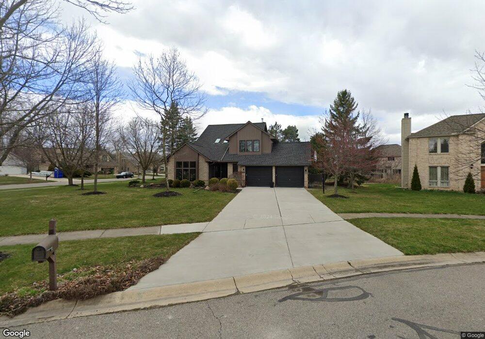
1683 Butterweed Ct Ann Arbor, MI 48103
Estimated Value: $550,000 - $575,000
3
Beds
2
Baths
1,969
Sq Ft
$285/Sq Ft
Est. Value
About This Home
This home is located at 1683 Butterweed Ct, Ann Arbor, MI 48103 and is currently estimated at $561,752, approximately $285 per square foot. 1683 Butterweed Ct is a home located in Washtenaw County with nearby schools including Dicken Elementary School, Slauson Middle School, and Pioneer High School.
Ownership History
Date
Name
Owned For
Owner Type
Purchase Details
Closed on
Jul 5, 2022
Sold by
Bawkon Bruce W
Bought by
Bawkon Bruce W
Current Estimated Value
Create a Home Valuation Report for This Property
The Home Valuation Report is an in-depth analysis detailing your home's value as well as a comparison with similar homes in the area
Home Values in the Area
Average Home Value in this Area
Purchase History
| Date | Buyer | Sale Price | Title Company |
|---|---|---|---|
| Bawkon Bruce W | -- | -- |
Source: Public Records
Tax History Compared to Growth
Tax History
| Year | Tax Paid | Tax Assessment Tax Assessment Total Assessment is a certain percentage of the fair market value that is determined by local assessors to be the total taxable value of land and additions on the property. | Land | Improvement |
|---|---|---|---|---|
| 2025 | -- | $275,200 | $0 | $0 |
| 2024 | $4,608 | $270,100 | $0 | $0 |
| 2023 | $4,428 | $254,400 | $0 | $0 |
| 2022 | $6,204 | $224,300 | $0 | $0 |
| 2021 | $5,899 | $220,000 | $0 | $0 |
| 2020 | $6,405 | $216,300 | $0 | $0 |
| 2019 | $5,957 | $205,000 | $205,000 | $0 |
| 2018 | $5,822 | $191,200 | $0 | $0 |
| 2017 | $5,638 | $188,100 | $0 | $0 |
| 2016 | $3,681 | $144,725 | $0 | $0 |
| 2015 | -- | $144,293 | $0 | $0 |
| 2014 | -- | $139,785 | $0 | $0 |
| 2013 | -- | $139,785 | $0 | $0 |
Source: Public Records
Map
Nearby Homes
- 1860 Chicory Ridge
- 1419 N Bay Dr Unit 73
- 1366 N Bay Dr Unit 144
- 1929 Harley Dr
- 1770 Harley Dr
- 1599 Scio Ridge Rd
- 2512 Jade Ct Unit 18
- 1740 S Maple Rd Unit 2
- 2126 Pauline Blvd Unit 104
- 1225 S Maple Rd Unit 307
- 813 E Summerfield Glen Cir
- 1235 S Maple Rd Unit 202
- 2120 Pauline Blvd Unit 305
- 1265 S Maple Rd Unit 207
- 2165 Pauline Ct Unit 14
- 1053 Bluestem Ln
- 2147 Pauline Ct Unit 17
- 2104 Pauline Blvd Unit 305
- 2033 Pauline Ct
- 609 Liberty Pointe Dr Unit 45
- 1689 Butterweed Ct Unit 90
- 1663 Snowberry Ridge Rd
- 1648 Chicory Ridge
- 1686 Snowberry Ridge Rd
- 1695 Butterweed Ct Unit 91
- 1662 Chicory Ridge
- 1672 Snowberry Ridge Rd
- 1700 Snowberry Ridge Rd Unit 61
- 1649 Snowberry Ridge Rd
- 1719 Butterweed Ct Unit 95
- 1676 Chicory Ridge
- 1701 Butterweed Ct Unit 92
- 1658 Snowberry Ridge Rd Unit 64
- 1714 Snowberry Ridge Rd
- 1713 Butterweed Ct
- 0 Snowberry Ridge Rd
- 1707 Butterweed Ct
- 1698 Chicory Ridge
- 1644 Snowberry Ridge Rd
- 1728 Snowberry Ridge Rd