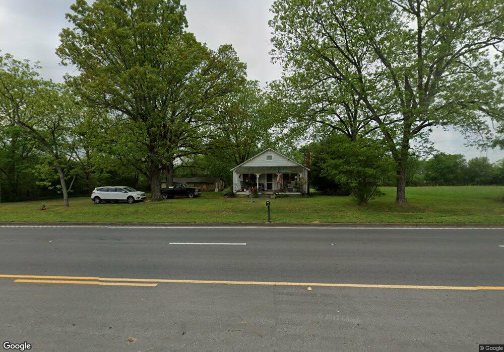
1683 Highway 53 Spur SW Calhoun, GA 30701
Estimated Value: $100,000 - $196,000
2
Beds
1
Bath
896
Sq Ft
$167/Sq Ft
Est. Value
About This Home
This home is located at 1683 Highway 53 Spur SW, Calhoun, GA 30701 and is currently estimated at $149,679, approximately $167 per square foot. 1683 Highway 53 Spur SW is a home located in Gordon County with nearby schools including Calhoun Primary School, Calhoun Elementary School, and Calhoun Middle School.
Ownership History
Date
Name
Owned For
Owner Type
Purchase Details
Closed on
Nov 3, 2010
Sold by
Miller Jeanette
Bought by
Stanley Debra Yvette and Lovingood Kyle R
Current Estimated Value
Create a Home Valuation Report for This Property
The Home Valuation Report is an in-depth analysis detailing your home's value as well as a comparison with similar homes in the area
Home Values in the Area
Average Home Value in this Area
Purchase History
| Date | Buyer | Sale Price | Title Company |
|---|---|---|---|
| Stanley Debra Yvette | -- | -- |
Source: Public Records
Tax History Compared to Growth
Tax History
| Year | Tax Paid | Tax Assessment Tax Assessment Total Assessment is a certain percentage of the fair market value that is determined by local assessors to be the total taxable value of land and additions on the property. | Land | Improvement |
|---|---|---|---|---|
| 2024 | $689 | $27,120 | $4,200 | $22,920 |
| 2023 | $649 | $25,560 | $4,200 | $21,360 |
| 2022 | $655 | $24,240 | $4,200 | $20,040 |
| 2021 | $547 | $19,520 | $4,200 | $15,320 |
| 2020 | $566 | $19,760 | $4,200 | $15,560 |
| 2019 | $581 | $20,160 | $4,200 | $15,960 |
| 2018 | $546 | $18,960 | $4,200 | $14,760 |
| 2017 | $536 | $18,080 | $4,200 | $13,880 |
| 2016 | $537 | $18,080 | $4,200 | $13,880 |
| 2015 | $526 | $17,560 | $4,200 | $13,360 |
| 2014 | $485 | $16,661 | $4,200 | $12,461 |
Source: Public Records
Map
Nearby Homes
- 121 Foxhall Dr SW
- 0 Highway 53 Spur SW Unit 7529096
- 130 Brookstone Dr SW
- 137 Regency Row SW
- 413 Beamer Rd SW
- 176 Village Way SW
- 00 Belmont Dr
- The Braselton II Plan at Fair Oak
- The Reynolds Plan at Fair Oak
- The Buford II Plan at Fair Oak
- The Lawson Plan at Fair Oak
- The Caldwell Plan at Fair Oak
- The Benson II Plan at Fair Oak
- The Greenbrier II Plan at Fair Oak
- 210 Madison Dr SW
- 0 Reeves Station Rd SW Unit 10548197
- 0 Reeves Station Rd SW Unit 7601645
- 490 McDaniel Station Rd SW
- 506 McDaniel Station Rd SW
- 458 McDaniel Station Rd SW
- 1648 Highway 53 Spur SW
- 1620 Highway 53 Spur SW
- 0 Highway 53 W Unit 8121172
- 00 Highway 53 W
- 0 Highway 53 W Unit 8091864
- 0 Highway 53 W Unit 8914953
- 0 Highway 53 W Unit 6706083
- 160 Westwind Industrial Dr SW
- 0 53 Spur Unit 5362499
- 1589 Highway 53 Spur SW
- 1548 Highway 53 Spur SW
- 1574 Highway 53 Spur SW
- 777 Oothcalooga St
- 0 Westwind Industrial Dr
- 1833 Highway 53 Spur SW
- 0000 Forest
- 0 W Wind Industrial Unit 3129083
- 1544 Highway 53 Spur SW
- 100 Deerfield Dr SW
- 133 Evergreen Place SW