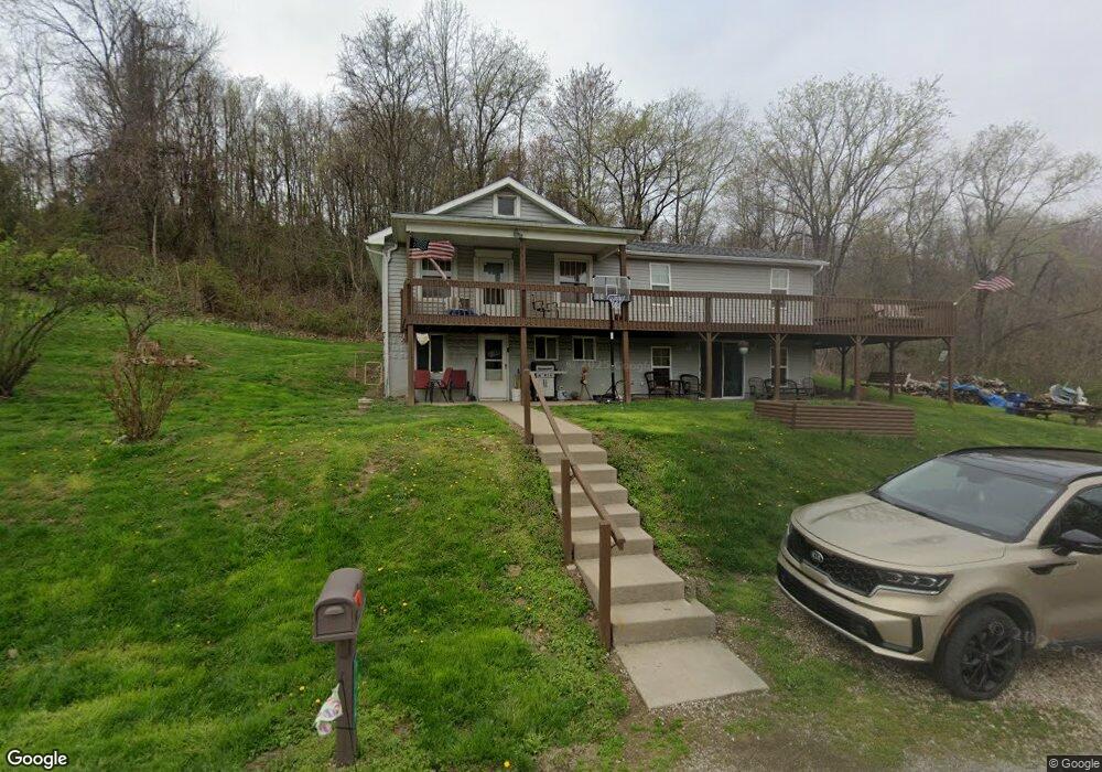
1685 Long Rd Zanesville, OH 43701
Estimated Value: $190,000 - $357,000
3
Beds
2
Baths
1,416
Sq Ft
$201/Sq Ft
Est. Value
About This Home
This home is located at 1685 Long Rd, Zanesville, OH 43701 and is currently estimated at $285,125, approximately $201 per square foot. 1685 Long Rd is a home located in Muskingum County with nearby schools including Perry Elementary School, East Muskingum Middle School, and Larry Miller Intermediate Elementary School.
Ownership History
Date
Name
Owned For
Owner Type
Purchase Details
Closed on
Aug 5, 2022
Sold by
Shook Keith A and Shook Alisha J
Bought by
Kettlewell Chad I and Kettlewell Candace J
Current Estimated Value
Purchase Details
Closed on
Jul 23, 2012
Sold by
Miller Bonnie J and Miller Glen
Bought by
Shook Keith A and Shook Alisha J
Home Financials for this Owner
Home Financials are based on the most recent Mortgage that was taken out on this home.
Original Mortgage
$62,182
Interest Rate
4.12%
Mortgage Type
FHA
Create a Home Valuation Report for This Property
The Home Valuation Report is an in-depth analysis detailing your home's value as well as a comparison with similar homes in the area
Home Values in the Area
Average Home Value in this Area
Purchase History
| Date | Buyer | Sale Price | Title Company |
|---|---|---|---|
| Kettlewell Chad I | -- | Coffman Ward D | |
| Kettlewell Chad I | -- | Coffman Ward D | |
| Shook Keith A | $63,800 | None Available |
Source: Public Records
Mortgage History
| Date | Status | Borrower | Loan Amount |
|---|---|---|---|
| Previous Owner | Shook Keith A | $62,182 |
Source: Public Records
Tax History Compared to Growth
Tax History
| Year | Tax Paid | Tax Assessment Tax Assessment Total Assessment is a certain percentage of the fair market value that is determined by local assessors to be the total taxable value of land and additions on the property. | Land | Improvement |
|---|---|---|---|---|
| 2024 | $2,254 | $62,475 | $11,760 | $50,715 |
| 2023 | $1,832 | $46,480 | $7,735 | $38,745 |
| 2022 | $1,645 | $43,960 | $6,475 | $37,485 |
| 2021 | $1,659 | $44,835 | $7,350 | $37,485 |
| 2020 | $1,559 | $40,705 | $6,650 | $34,055 |
| 2019 | $1,552 | $40,705 | $6,650 | $34,055 |
| 2018 | $1,582 | $40,705 | $6,650 | $34,055 |
| 2017 | $1,199 | $32,235 | $6,545 | $25,690 |
| 2016 | $1,201 | $32,240 | $6,550 | $25,690 |
| 2015 | $1,231 | $32,240 | $6,550 | $25,690 |
| 2013 | $905 | $21,460 | $6,550 | $14,910 |
Source: Public Records
Map
Nearby Homes
- 2125 Long Rd
- 0 Okey Rd Unit 5130633
- 0 E Wheeling Rd Unit 5162172
- 380 Urban Hill Rd
- 350 Urban Hill Rd
- 6265 Canterbury Way Unit LOT 30
- 7115 East Pike
- 6600 Bridgeville Dr
- 7915 East Pike
- 5180 Pine Valley Dr
- 2043 Southern Rd
- 310 Trappers Hollow Rd
- 400 Spring Valley Dr
- 130 Airport Rd
- 100 Linvale Dr
- 515 Norwich Valley Rd
- 1305 Bald Hill Rd
- 365 Walters Way
- 4460 East Pike
- 360 Walters Way
- 0 Long Rd
- 1795 Long Rd
- 1855 Long Rd
- 1745 Long Rd
- 1660 Long Rd
- 1665 Long Rd
- 2121 Long Rd
- 1500 Long Rd
- 2135 Long Rd
- 2137 Long Rd
- 1430 Rustic Ridge Rd
- 1500 Rustic Ridge Rd
- 2150 Long Rd
- 2195 Long Rd
- 1530 Rustic Ridge Rd
- 7615 Clay Pike
- 1520 Rustic Ridge Rd
- 1420 Long Rd
- 1565 Rustic Ridge Rd
- 1521 Rustic Ridge Rd