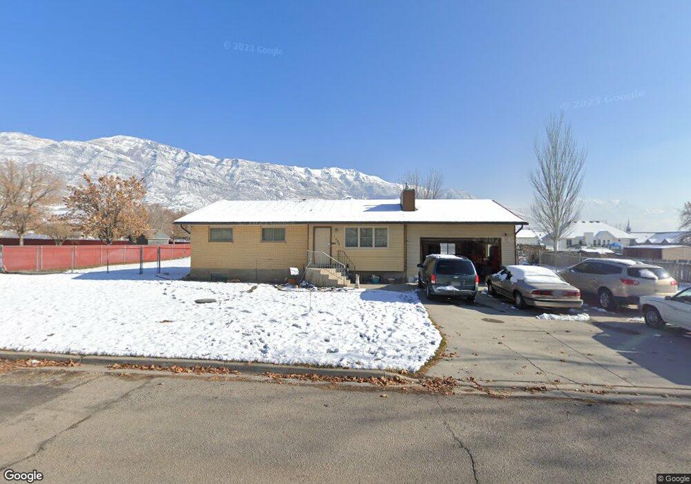
1686 N 1520 W Pleasant Grove, UT 84062
Estimated Value: $483,000 - $586,000
5
Beds
3
Baths
2,482
Sq Ft
$220/Sq Ft
Est. Value
About This Home
This home is located at 1686 N 1520 W, Pleasant Grove, UT 84062 and is currently estimated at $545,779, approximately $219 per square foot. 1686 N 1520 W is a home located in Utah County with nearby schools including Mount Mahogany School, Pleasant Grove Junior High School, and Pleasant Grove High School.
Ownership History
Date
Name
Owned For
Owner Type
Purchase Details
Closed on
Aug 8, 2024
Sold by
Wayne And Linda Robertson Family Trust and Robertson Linda J
Bought by
Skoog Joel and Skoog Rebecca
Current Estimated Value
Home Financials for this Owner
Home Financials are based on the most recent Mortgage that was taken out on this home.
Original Mortgage
$460,800
Outstanding Balance
$455,576
Interest Rate
6.86%
Mortgage Type
New Conventional
Estimated Equity
$90,203
Purchase Details
Closed on
Feb 25, 2021
Sold by
Robertson Wayne G and Robertson Linda J
Bought by
Wayne And Linda Robertson Family Trust and Robertson
Home Financials for this Owner
Home Financials are based on the most recent Mortgage that was taken out on this home.
Original Mortgage
$284,700
Interest Rate
3%
Mortgage Type
VA
Purchase Details
Closed on
Jun 25, 2018
Sold by
Robertson Wayne G and Robertson Linda J
Bought by
Robertson Wayne G and Robertson Linda J
Home Financials for this Owner
Home Financials are based on the most recent Mortgage that was taken out on this home.
Original Mortgage
$285,871
Interest Rate
4.6%
Mortgage Type
VA
Purchase Details
Closed on
May 11, 2017
Sold by
Robertson Wayne G and Robertson Linda J
Bought by
Robertson Wayne G and Robertson Linda J
Home Financials for this Owner
Home Financials are based on the most recent Mortgage that was taken out on this home.
Original Mortgage
$239,031
Interest Rate
4.14%
Mortgage Type
VA
Purchase Details
Closed on
Mar 17, 2016
Sold by
Robertson Wayne G and Robertson Linda J
Bought by
Robertson Wayne G and Robertson Linda J
Purchase Details
Closed on
Apr 10, 2002
Sold by
Robertson Linda J
Bought by
Robertson Wayne G and Robertson Linda J
Home Financials for this Owner
Home Financials are based on the most recent Mortgage that was taken out on this home.
Original Mortgage
$97,500
Interest Rate
6.78%
Purchase Details
Closed on
Dec 19, 1997
Sold by
Herbert Gary R and Herbert Jeanette
Bought by
Robertson Wayne G and Robertson Linda J
Create a Home Valuation Report for This Property
The Home Valuation Report is an in-depth analysis detailing your home's value as well as a comparison with similar homes in the area
Home Values in the Area
Average Home Value in this Area
Purchase History
| Date | Buyer | Sale Price | Title Company |
|---|---|---|---|
| Skoog Joel | -- | Inwest Title | |
| Wayne And Linda Robertson Family Trust | -- | Amrock | |
| Wayne And Linda Robertson Family Trust | -- | Amrock | |
| Robertson Wayne G | -- | Amrock Llc | |
| Robertson Wayne G | -- | Title Source | |
| Robertson Wayne G | -- | Title Source | |
| Robertson Wayne G | -- | None Available | |
| Robertson Wayne G | -- | Accommodation | |
| Robertson Wayne G | -- | None Available | |
| Robertson Wayne G | -- | Backman Stewart Title Servic | |
| Robertson Linda J | -- | Backman Stewart Title Servic | |
| Robertson Wayne G | -- | -- |
Source: Public Records
Mortgage History
| Date | Status | Borrower | Loan Amount |
|---|---|---|---|
| Open | Skoog Joel | $460,800 | |
| Previous Owner | Robertson Wayne G | $284,700 | |
| Previous Owner | Robertson Wayne G | $285,871 | |
| Previous Owner | Robertson Wayne G | $239,031 | |
| Previous Owner | Robertson Linda J | $97,500 |
Source: Public Records
Tax History Compared to Growth
Tax History
| Year | Tax Paid | Tax Assessment Tax Assessment Total Assessment is a certain percentage of the fair market value that is determined by local assessors to be the total taxable value of land and additions on the property. | Land | Improvement |
|---|---|---|---|---|
| 2025 | $2,283 | $288,090 | $291,000 | $232,800 |
| 2024 | $2,283 | $266,475 | $0 | $0 |
| 2023 | $2,221 | $266,585 | $0 | $0 |
| 2022 | $2,221 | $269,940 | $0 | $0 |
| 2021 | $1,838 | $340,200 | $182,700 | $157,500 |
| 2020 | $1,702 | $308,900 | $163,100 | $145,800 |
| 2019 | $1,593 | $298,900 | $154,500 | $144,400 |
| 2018 | $1,531 | $271,600 | $146,000 | $125,600 |
| 2017 | $1,470 | $138,820 | $0 | $0 |
| 2016 | $1,237 | $112,805 | $0 | $0 |
| 2015 | $1,204 | $103,950 | $0 | $0 |
| 2014 | $1,113 | $95,260 | $0 | $0 |
Source: Public Records
Map
Nearby Homes
- 1320 W 1340 N
- 1171 N 1430 W
- 980 W 1800 N
- 1141 E 50 N
- 1897 N 900 W
- Lytham Plan at Grove Acres
- 1498 W 1060 N Unit 5
- 1096 N 1420 St W Unit 27
- 2254 N 1560 W
- 1065 N 1420 W
- 1541 W 1060 N
- Konlee Plan at Makin Dreams
- Alexa Plan at Makin Dreams
- Callahan Plan at Makin Dreams
- Hailey Plan at Makin Dreams
- Alydia Plan at Makin Dreams
- Addison Plan at Makin Dreams
- Julia Plan at Makin Dreams
- 1531 N 750 W Unit 4
- Aaron Plan at Makin Dreams
- 1728 N 1520 W
- 1644 N 1520 W
- 1655 Leslie Cir
- 1685 N 1520 W
- 1697 Leslie Cir
- 1729 N 1520 W
- 1645 N 1520 W
- 1631 Leslie Cir
- 1770 N 1520 W
- 1435 W 1800 N
- 1586 N 1520 W
- 1338 W 1620 N
- 1465 W 1800 N
- 1694 Leslie Cir
- 1585 N 1520 W
- 1626 Leslie Cir
- 1648 Leslie Cir
- 1427 W 1620 N Unit 102
- 1470 W 1800 N
- 1405 W 1800 N