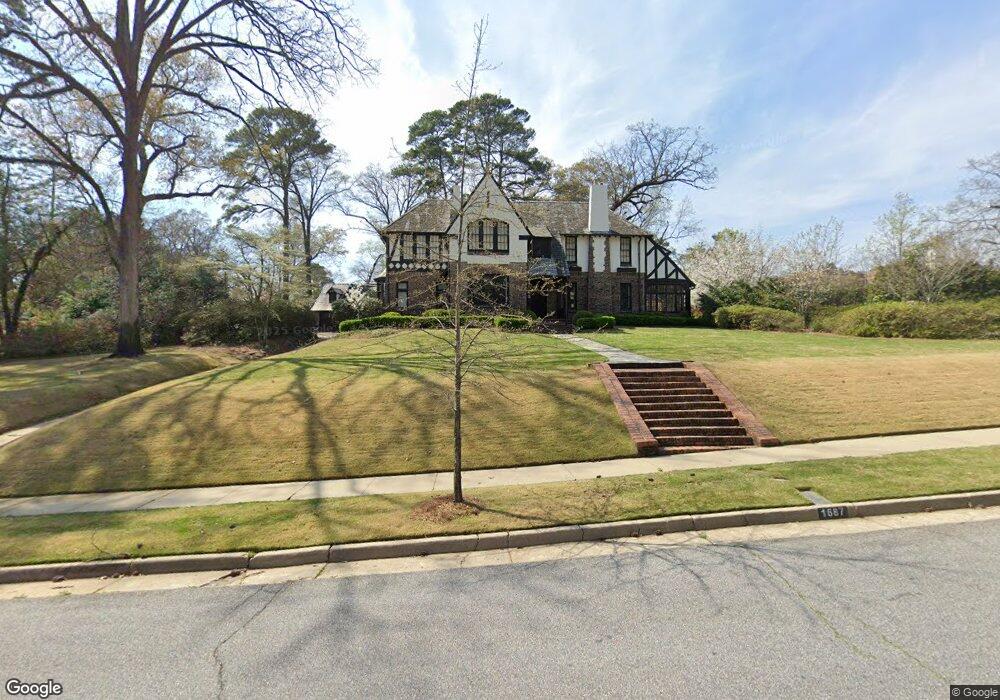
1687 Flournoy Dr Columbus, GA 31906
Peacock Woods-Dimon Circle NeighborhoodEstimated Value: $539,000 - $1,099,058
4
Beds
4
Baths
3,300
Sq Ft
$273/Sq Ft
Est. Value
About This Home
This home is located at 1687 Flournoy Dr, Columbus, GA 31906 and is currently estimated at $901,019, approximately $273 per square foot. 1687 Flournoy Dr is a home located in Muscogee County with nearby schools including Richards Middle School, Hardaway High School, and Wynnton Elementary School.
Ownership History
Date
Name
Owned For
Owner Type
Purchase Details
Closed on
Mar 16, 2007
Sold by
Nix John C
Bought by
Nix John C and Nix Jackie C
Current Estimated Value
Home Financials for this Owner
Home Financials are based on the most recent Mortgage that was taken out on this home.
Original Mortgage
$130,000
Outstanding Balance
$78,730
Interest Rate
6.27%
Mortgage Type
Stand Alone Second
Estimated Equity
$822,289
Create a Home Valuation Report for This Property
The Home Valuation Report is an in-depth analysis detailing your home's value as well as a comparison with similar homes in the area
Home Values in the Area
Average Home Value in this Area
Purchase History
| Date | Buyer | Sale Price | Title Company |
|---|---|---|---|
| Nix John C | -- | None Available | |
| Nix John C | $900,000 | None Available |
Source: Public Records
Mortgage History
| Date | Status | Borrower | Loan Amount |
|---|---|---|---|
| Open | Nix John C | $130,000 | |
| Open | Nix John C | $720,000 | |
| Closed | Nix John C | $130,000 |
Source: Public Records
Tax History Compared to Growth
Tax History
| Year | Tax Paid | Tax Assessment Tax Assessment Total Assessment is a certain percentage of the fair market value that is determined by local assessors to be the total taxable value of land and additions on the property. | Land | Improvement |
|---|---|---|---|---|
| 2025 | $14,277 | $490,420 | $37,080 | $453,340 |
| 2024 | $14,276 | $490,420 | $37,080 | $453,340 |
| 2023 | $13,671 | $490,420 | $37,080 | $453,340 |
| 2022 | $14,890 | $387,713 | $37,080 | $350,633 |
| 2021 | $14,914 | $381,220 | $37,080 | $344,140 |
| 2020 | $14,887 | $381,220 | $37,080 | $344,140 |
| 2019 | $14,936 | $381,220 | $37,080 | $344,140 |
| 2018 | $14,936 | $380,644 | $37,080 | $343,564 |
| 2017 | $14,985 | $380,644 | $37,080 | $343,564 |
| 2016 | $15,041 | $377,898 | $27,348 | $350,550 |
| 2015 | $15,060 | $377,898 | $27,348 | $350,550 |
| 2014 | $15,078 | $377,898 | $27,348 | $350,550 |
| 2013 | -- | $360,227 | $27,348 | $332,879 |
Source: Public Records
Map
Nearby Homes
- 1680 Flournoy Dr
- 1800 Wildwood Ave
- 1809 Carter Ave
- 2016 Poplar Dr
- 1400 Eberhart Ave
- 1557 18th Ave
- 2104 Cherokee Ave
- 1531 Wildwood Ave
- 1609 17th St
- 1806 Stark Ave
- 2227 15th St
- 1706 Stark Ave
- 1917 Dimon St
- 1700 Stark Ave
- 1504 17th Ave
- 1641 16th Ave
- 1525 19th St
- 2125 13th St Unit 12
- 2133 13th St
- 2230 Cherokee Ave Unit 10
- 1929 Flournoy Dr
- 1920 17th St
- 1660 Flournoy Dr
- 1925 Flournoy Dr
- 1630 Cherokee Ave
- 1921 Flournoy Dr
- 2011 Brookside Dr
- 1930 Flournoy Dr
- 1919 Flournoy Dr
- 1661 Forest Ave
- 1641 Summit Dr
- 1920 Flournoy Dr
- 1538 Eberhart Ave
- 2021 Brookside Dr
- 1533 Eberhart Ave
- 1908 Flournoy Dr
- 1710 Forest Ave
- 1700 Forest Ave
- 1714 Forest Ave
- 1720 Forest Ave