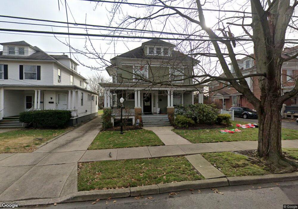
169 S Maple Ave Kingston, PA 18704
Estimated Value: $229,393 - $258,000
2
Beds
1
Bath
900
Sq Ft
$273/Sq Ft
Est. Value
About This Home
This home is located at 169 S Maple Ave, Kingston, PA 18704 and is currently estimated at $245,598, approximately $272 per square foot. 169 S Maple Ave is a home located in Luzerne County with nearby schools including Wyoming Valley West Senior High School, Wyoming Valley Kingston Montessori School, and Good Shepherd Academy.
Ownership History
Date
Name
Owned For
Owner Type
Purchase Details
Closed on
Oct 18, 2017
Sold by
Grueninger Mark
Bought by
Narsun Properties Llc
Current Estimated Value
Home Financials for this Owner
Home Financials are based on the most recent Mortgage that was taken out on this home.
Original Mortgage
$77,520
Outstanding Balance
$42,211
Interest Rate
3.88%
Mortgage Type
Purchase Money Mortgage
Estimated Equity
$203,387
Create a Home Valuation Report for This Property
The Home Valuation Report is an in-depth analysis detailing your home's value as well as a comparison with similar homes in the area
Home Values in the Area
Average Home Value in this Area
Purchase History
| Date | Buyer | Sale Price | Title Company |
|---|---|---|---|
| Narsun Properties Llc | $96,900 | None Available |
Source: Public Records
Mortgage History
| Date | Status | Borrower | Loan Amount |
|---|---|---|---|
| Open | Narsun Properties Llc | $77,520 |
Source: Public Records
Tax History Compared to Growth
Tax History
| Year | Tax Paid | Tax Assessment Tax Assessment Total Assessment is a certain percentage of the fair market value that is determined by local assessors to be the total taxable value of land and additions on the property. | Land | Improvement |
|---|---|---|---|---|
| 2025 | $3,488 | $132,200 | $18,800 | $113,400 |
| 2024 | $3,488 | $132,200 | $18,800 | $113,400 |
| 2023 | $3,428 | $132,200 | $18,800 | $113,400 |
| 2022 | $3,404 | $132,200 | $18,800 | $113,400 |
| 2021 | $3,306 | $132,200 | $18,800 | $113,400 |
| 2020 | $3,306 | $132,200 | $18,800 | $113,400 |
| 2019 | $3,209 | $132,200 | $18,800 | $113,400 |
| 2018 | $3,109 | $132,200 | $18,800 | $113,400 |
| 2017 | $3,021 | $132,200 | $18,800 | $113,400 |
| 2016 | -- | $132,200 | $18,800 | $113,400 |
| 2015 | -- | $132,200 | $18,800 | $113,400 |
| 2014 | -- | $132,200 | $18,800 | $113,400 |
Source: Public Records
Map
Nearby Homes
- 143 Zerby Ave
- LOTS Zerby Ave
- 116 Herman St
- 15 Hillside Ave
- 59 N Loveland Ave
- 100 N Loveland Ave
- 265 Lawrence St
- 39 S Thomas Ave
- 181 Hillside Ave
- 119 Green St
- 216 Reynolds St
- 624 Swallow St
- 474 Chestnut Ave
- 194 Green St
- 574 Cherry St
- 223 225 Green St
- 18 W Grove St
- 278 Pringle St
- 127 Division St
- 745 Main St
- 167 S Maple Ave
- 175 S Maple Ave
- 181 S Maple Ave
- 15 Belding Ln
- 165 S Maple Ave
- 153 S Maple Ave
- 174 S Sprague Ave
- 180 S Sprague Ave
- 172 S Sprague Ave
- 168 S Maple Ave
- 178 S Sprague Ave
- 189 S Maple Ave
- 172 S Maple Ave
- 189 S Maple Ave
- 191 S Maple Ave
- 145 S Maple Ave
- 160 S Maple Ave
- 784 W Market St
- 840 W Market St
- 150 S Maple Ave