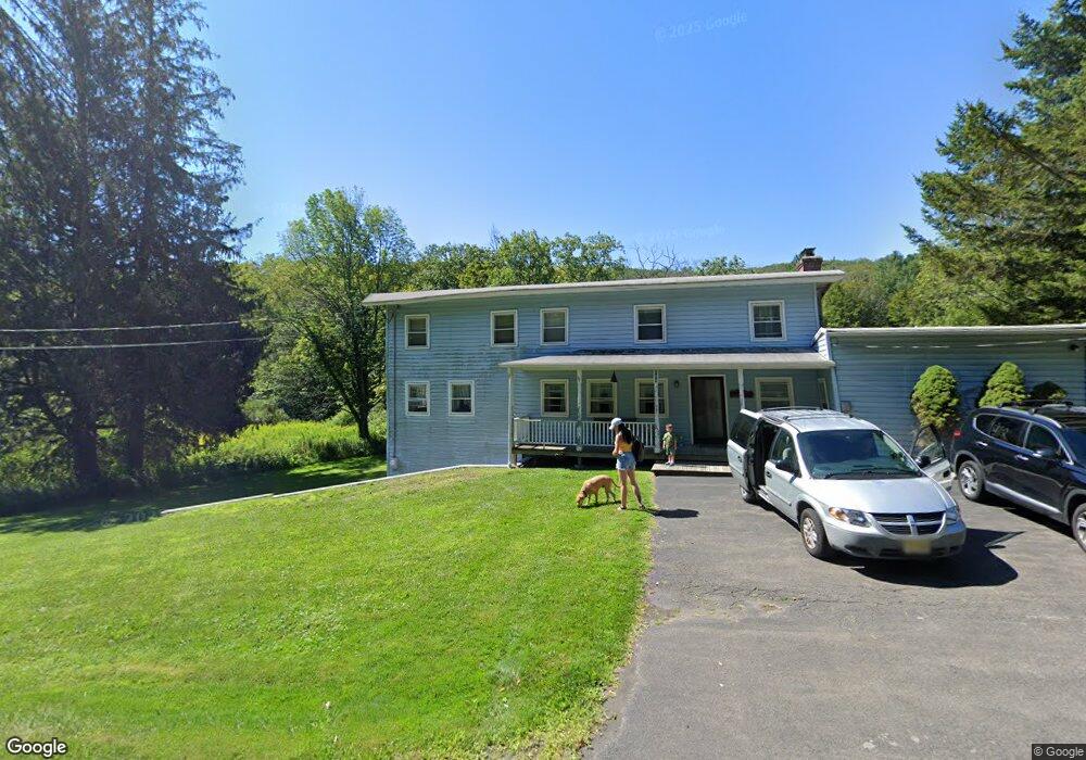
169 State Route 203 Spencertown, NY 12165
Estimated Value: $362,241 - $694,000
5
Beds
3
Baths
2,142
Sq Ft
$243/Sq Ft
Est. Value
About This Home
This home is located at 169 State Route 203, Spencertown, NY 12165 and is currently estimated at $520,810, approximately $243 per square foot. 169 State Route 203 is a home with nearby schools including Mary E. Dardess Elementary School, Chatham Middle School, and Chatham High School.
Ownership History
Date
Name
Owned For
Owner Type
Purchase Details
Closed on
Nov 21, 1997
Sold by
Ouwerkerk Ronald R
Bought by
Jablonski Michael
Current Estimated Value
Purchase Details
Closed on
Jul 3, 1997
Sold by
Mortgage Federal Home Loa N Co
Bought by
Ouwerkerk Ronald R
Purchase Details
Closed on
Mar 14, 1997
Purchase Details
Closed on
Apr 8, 1994
Sold by
Jablonski Philip and Jablonski Rita
Bought by
Eaton Lynn and Eaton Elizabeth
Create a Home Valuation Report for This Property
The Home Valuation Report is an in-depth analysis detailing your home's value as well as a comparison with similar homes in the area
Home Values in the Area
Average Home Value in this Area
Purchase History
| Date | Buyer | Sale Price | Title Company |
|---|---|---|---|
| Jablonski Michael | $55,000 | -- | |
| Ouwerkerk Ronald R | $36,500 | -- | |
| -- | $60,000 | -- | |
| Eaton Lynn | $90,000 | -- |
Source: Public Records
Tax History Compared to Growth
Tax History
| Year | Tax Paid | Tax Assessment Tax Assessment Total Assessment is a certain percentage of the fair market value that is determined by local assessors to be the total taxable value of land and additions on the property. | Land | Improvement |
|---|---|---|---|---|
| 2024 | $4,183 | $182,000 | $25,600 | $156,400 |
| 2023 | $4,042 | $182,000 | $25,600 | $156,400 |
| 2022 | $3,834 | $182,000 | $25,600 | $156,400 |
| 2021 | $3,965 | $182,000 | $25,600 | $156,400 |
| 2020 | $4,055 | $182,000 | $25,600 | $156,400 |
| 2019 | $4,212 | $182,000 | $25,600 | $156,400 |
| 2018 | $4,212 | $173,000 | $25,200 | $147,800 |
| 2017 | $4,090 | $173,000 | $25,200 | $147,800 |
| 2016 | $4,072 | $173,000 | $25,200 | $147,800 |
| 2015 | -- | $173,000 | $25,200 | $147,800 |
| 2014 | -- | $173,000 | $25,200 | $147,800 |
Source: Public Records
Map
Nearby Homes
- 120 Route 203
- 0 Amy's Ln Unit 152415
- 11549 State Route 22
- 35 Jilroy Ln
- 0 W Hill Rd Unit 20253831
- 0 W Hill Rd Unit 155309
- 1 W Hill Rd
- 3 W Hill Rd
- 2 W Hill Rd
- 208 E East Hill Rd
- 0 Old Macedonia Rd Unit 153065
- 11351 New York 22
- 0 Harrington Dr
- 12 Reed Rd
- 470 Harrington Dr
- 214 Fog Hill Rd
- 0 New York 22
- 7 Partridge Dr
- 0 Macedonia Rd
- 0 Reed Rd Unit 153134
- 182 State Route 203
- 195 New York 203
- 195 State Route 203
- 203 New York 203
- 0 New York 203
- 79 Route 203
- 1134 Route 203
- 912 Route 203
- 182 New York 203
- 176 Route 203
- 128 State Route 203
- 128 New York 203
- 127 State Route 203
- 214 State Route 203
- 182 State Route 203 --
- 319 New York 203
- 121 State Route 203
- 108 State Route 203
- 243 New York 203
- 96 State Route 203