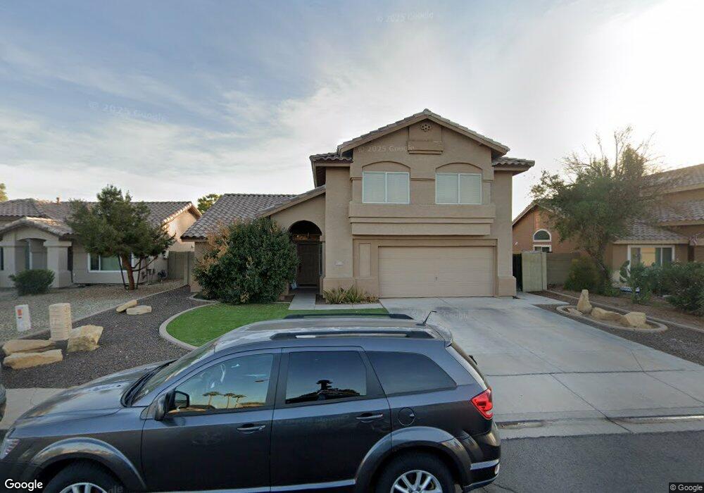
169 W Patrick St Gilbert, AZ 85233
Southwest Gilbert NeighborhoodEstimated Value: $480,320 - $607,000
Studio
4
Baths
2,258
Sq Ft
$248/Sq Ft
Est. Value
About This Home
This home is located at 169 W Patrick St, Gilbert, AZ 85233 and is currently estimated at $559,080, approximately $247 per square foot. 169 W Patrick St is a home located in Maricopa County with nearby schools including Chandler Traditional Academy - Liberty Campus, Willis Junior High School, and Imagine West Gilbert Elementary School.
Ownership History
Date
Name
Owned For
Owner Type
Purchase Details
Closed on
Dec 18, 1995
Sold by
Bpc Inc
Bought by
Hamilton Linda
Current Estimated Value
Home Financials for this Owner
Home Financials are based on the most recent Mortgage that was taken out on this home.
Original Mortgage
$106,480
Interest Rate
7.38%
Mortgage Type
New Conventional
Create a Home Valuation Report for This Property
The Home Valuation Report is an in-depth analysis detailing your home's value as well as a comparison with similar homes in the area
Home Values in the Area
Average Home Value in this Area
Purchase History
| Date | Buyer | Sale Price | Title Company |
|---|---|---|---|
| Hamilton Linda | $136,480 | Fidelity Title |
Source: Public Records
Mortgage History
| Date | Status | Borrower | Loan Amount |
|---|---|---|---|
| Closed | Hamilton Linda | $106,480 |
Source: Public Records
Tax History
| Year | Tax Paid | Tax Assessment Tax Assessment Total Assessment is a certain percentage of the fair market value that is determined by local assessors to be the total taxable value of land and additions on the property. | Land | Improvement |
|---|---|---|---|---|
| 2025 | $1,895 | $23,799 | -- | -- |
| 2024 | $1,824 | $22,666 | -- | -- |
| 2023 | $1,824 | $37,700 | $7,540 | $30,160 |
| 2022 | $1,758 | $29,020 | $5,800 | $23,220 |
| 2021 | $1,842 | $27,720 | $5,540 | $22,180 |
| 2020 | $1,831 | $26,060 | $5,210 | $20,850 |
| 2019 | $1,758 | $23,860 | $4,770 | $19,090 |
| 2018 | $1,707 | $22,420 | $4,480 | $17,940 |
| 2017 | $1,600 | $21,060 | $4,210 | $16,850 |
| 2016 | $1,549 | $20,620 | $4,120 | $16,500 |
| 2015 | $1,496 | $20,160 | $4,030 | $16,130 |
Source: Public Records
Map
Nearby Homes
- 1900 S Oak St
- 247 W Oxford Ln
- 172 W Shannon St
- 13613 E Shannon St
- 34 W Megan St
- 562 N Kimberlee Way
- 1774 S 131st St
- 79 W Gail Dr
- 226 W Gail Dr
- 141 W Baylor Ln
- 2691 E Hulet Dr
- 1571 S Monterey St
- 252 N Wilson Dr
- 1718 S 140th Place
- 2124 E Oakland St
- 15606 S Gilbert Rd Unit 109
- 15606 S Gilbert Rd Unit 63
- 15606 S Gilbert Rd Unit 50
- 13839 E Morgan Dr
- 2056 E Stephens Place
- 159 W Patrick St
- 179 W Patrick St
- 168 W Shamrock St
- 149 W Patrick St
- 178 W Shamrock St
- 160 W Shamrock St Unit II
- 189 W Patrick St
- 1778 S Alder St
- 186 W Shamrock St Unit II
- 152 W Shamrock St
- 141 W Patrick St
- 150 W Patrick St
- 1777 S Oak St
- 1770 S Alder St
- 142 W Patrick St
- 142 W Shamrock St
- 131 W Patrick St
- 1769 S Oak St
- 1762 S Alder St
- 134 W Patrick St
Your Personal Tour Guide
Ask me questions while you tour the home.