
Seller's Agent in 2025
Melissa Atherholt
Century 21 Redwood Realty
(240) 674-2932
61 Total Sales
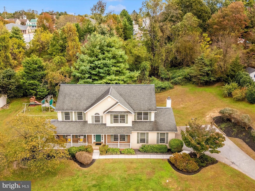
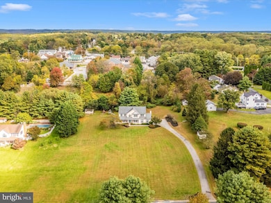
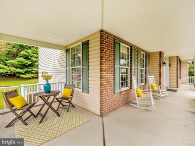
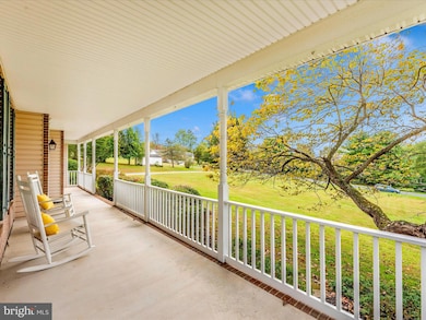
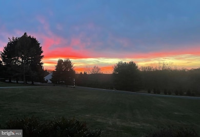
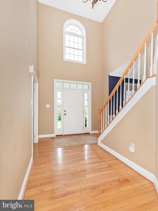
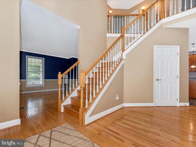
Beautiful Colonial on over an acre of land in Mt. Carmel Meadows! Peaceful Country Living with Easy Access to Hunt Valley and Baltimore. Enjoy sunsets and quiet evenings from your classic wraparound front porch and take in morning sunrises from the expansive back deck. Nestled on a quiet cul-de-sac street this inviting 4-bedroom, 31⁄2-bath home offers over 3,400 square feet of living space on more than an acre of private, tree-lined land that backs to woods. Located in the highly sought-after Hereford School District—Sparks Elementary, Hereford Middle, and Hereford High—this home blends small neighborhood charm with the open, peaceful feel of Monkton’s countryside. Step into a grand two-story foyer with elegant hardwood floors and 9-foot ceilings on both the main and upper levels, creating a bright and spacious atmosphere throughout. The gourmet kitchen features an island, 42-inch cabinetry, gas cooking, nice-sized pantry, and a sunny bump-out window making space for a large table. A warm and inviting family room with a wood-burning fireplace provides the ideal spot for cozy winter evenings -- Enjoy movie nights with the smart TV and surround sound which will remain at the property. Upstairs, the luxury primary suite showcases a cathedral ceiling, massive walk-in closet, and a spa-like bath with a soaking tub and separate shower—your own private retreat! The lower level has a large finished rec room, 8-foot ceilings, a full bath, walk-up access to the side yard and abundant storage which is ready to become a recreation room, home gym, or guest suite. Major home updates that bring peace of mind: HVAC system (2017), 50-year architectural roof (2014) with transferable warranty, Water heater and Culligan full-house water treatment system with reverse osmosis water system that goes to the kitchen sink (2023). Located in scenic Monkton, this property offers true country living with convenient access to Hunt Valley, Baltimore, and I-83. You’ll love the quiet setting and easy commute, with nature and amenities close at hand. Walk to the local library or take a short drive to the Torrey C. Brown Rail Trail for miles of biking and walking along the Gunpowder Falls River. Nearby parks, nature preserves, and Hunt Valley Towne Centre add to the area’s exceptional quality of life. Welcome home!
Last Agent to Sell the Property
(301) 208-2288 atherholtm@gmail.com Century 21 Redwood Realty License #528672 Listed on: 10/21/2025
| Date | Type | Sale Price | Title Company |
|---|---|---|---|
| Deed | $695,000 | Home First Title | |
| Deed | -- | None Listed On Document | |
| Deed | $88,610 | -- |
| Date | Status | Loan Amount | Loan Type |
|---|---|---|---|
| Open | $590,750 | New Conventional |
| Date | Event | Price | List to Sale | Price per Sq Ft |
|---|---|---|---|---|
| 12/01/2025 12/01/25 | Sold | $695,000 | 0.0% | $202 / Sq Ft |
| 10/21/2025 10/21/25 | For Sale | $695,000 | -- | $202 / Sq Ft |
| Year | Tax Paid | Tax Assessment Tax Assessment Total Assessment is a certain percentage of the fair market value that is determined by local assessors to be the total taxable value of land and additions on the property. | Land | Improvement |
|---|---|---|---|---|
| 2025 | $6,909 | $612,300 | $99,700 | $512,600 |
| 2024 | $6,909 | $570,267 | $0 | $0 |
| 2023 | $3,107 | $528,233 | $0 | $0 |
| 2022 | $5,899 | $486,200 | $117,900 | $368,300 |
| 2021 | $5,953 | $486,200 | $117,900 | $368,300 |
| 2020 | $5,953 | $486,200 | $117,900 | $368,300 |
| 2019 | $5,953 | $498,000 | $117,900 | $380,100 |
| 2018 | $5,723 | $475,733 | $0 | $0 |
| 2017 | $5,451 | $453,467 | $0 | $0 |
| 2016 | $4,345 | $431,200 | $0 | $0 |
| 2015 | $4,345 | $422,033 | $0 | $0 |
| 2014 | $4,345 | $412,867 | $0 | $0 |
Seller's Agent in 2025
Melissa Atherholt
Century 21 Redwood Realty
(240) 674-2932
61 Total Sales
Buyer's Agent in 2025
Jess Bauer
The KW Collective
(410) 274-2311
87 Total Sales
Source: Bright MLS
MLS Number: MDBC2141312
APN: 07-2200028211
Disclaimer: Certain information contained herein is derived from information provided by parties other than Homes.com. All information provided is deemed reliable, but is not guaranteed to be accurate and should be independently verified.
![]() The data relating to real estate for sale on this website appears in part through the BRIGHT Internet Data Exchange program, a voluntary cooperative exchange of property listing data between licensed real estate brokerage firms, and is provided by BRIGHT through a licensing agreement.
The data relating to real estate for sale on this website appears in part through the BRIGHT Internet Data Exchange program, a voluntary cooperative exchange of property listing data between licensed real estate brokerage firms, and is provided by BRIGHT through a licensing agreement.
Listing information is from various brokers who participate in the Bright MLS IDX program and not all listings may be visible on the site.
The property information being provided on or through the website is for the personal, non-commercial use of consumers and such information may not be used for any purpose other than to identify prospective properties consumers may be interested in purchasing.
Some properties which appear for sale on the website may no longer be available because they are for instance, under contract, sold or are no longer being offered for sale.
Property information displayed is deemed reliable but is not guaranteed.
Copyright 2026 Bright MLS, Inc.
Ask me questions while you tour the home.