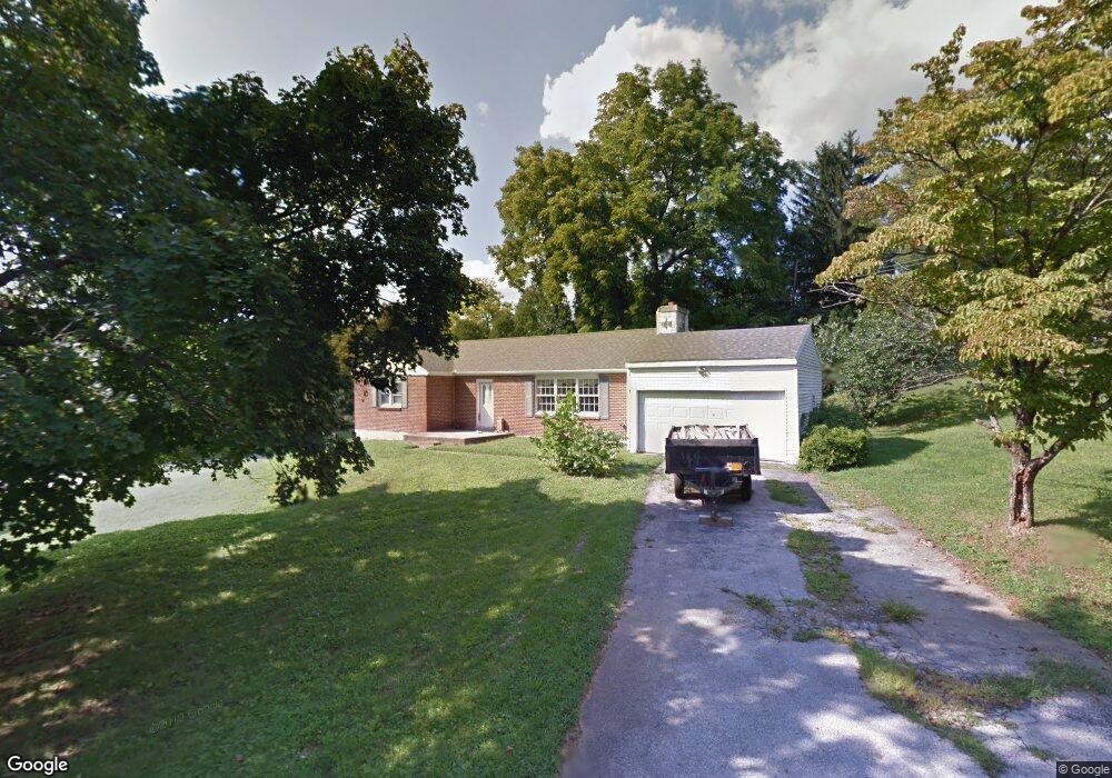
1691 Lenni Dr West Chester, PA 19382
Estimated Value: $486,000 - $693,000
3
Beds
2
Baths
1,643
Sq Ft
$334/Sq Ft
Est. Value
About This Home
This home is located at 1691 Lenni Dr, West Chester, PA 19382 and is currently estimated at $549,241, approximately $334 per square foot. 1691 Lenni Dr is a home located in Chester County with nearby schools including Pocopson Elementary School, Charles F. Patton Middle School, and Unionville High School.
Ownership History
Date
Name
Owned For
Owner Type
Purchase Details
Closed on
Nov 28, 1994
Sold by
Bria M Donna
Bought by
Forrest Frederick T and Forrest Margaret O
Current Estimated Value
Home Financials for this Owner
Home Financials are based on the most recent Mortgage that was taken out on this home.
Original Mortgage
$142,025
Interest Rate
8.81%
Create a Home Valuation Report for This Property
The Home Valuation Report is an in-depth analysis detailing your home's value as well as a comparison with similar homes in the area
Home Values in the Area
Average Home Value in this Area
Purchase History
| Date | Buyer | Sale Price | Title Company |
|---|---|---|---|
| Forrest Frederick T | $149,500 | -- |
Source: Public Records
Mortgage History
| Date | Status | Borrower | Loan Amount |
|---|---|---|---|
| Closed | Forrest Frederick T | $142,025 |
Source: Public Records
Tax History Compared to Growth
Tax History
| Year | Tax Paid | Tax Assessment Tax Assessment Total Assessment is a certain percentage of the fair market value that is determined by local assessors to be the total taxable value of land and additions on the property. | Land | Improvement |
|---|---|---|---|---|
| 2025 | $5,381 | $139,030 | $32,590 | $106,440 |
| 2024 | $5,381 | $139,030 | $32,590 | $106,440 |
| 2023 | $5,211 | $139,030 | $32,590 | $106,440 |
| 2022 | $5,104 | $139,030 | $32,590 | $106,440 |
| 2021 | $4,980 | $139,030 | $32,590 | $106,440 |
| 2020 | $4,967 | $139,030 | $32,590 | $106,440 |
| 2019 | $10,255 | $139,030 | $32,590 | $106,440 |
| 2018 | $4,863 | $139,030 | $32,590 | $106,440 |
| 2017 | $4,763 | $139,030 | $32,590 | $106,440 |
| 2016 | $551 | $139,030 | $32,590 | $106,440 |
| 2015 | $551 | $139,030 | $32,590 | $106,440 |
| 2014 | $551 | $139,030 | $32,590 | $106,440 |
Source: Public Records
Map
Nearby Homes
- 1740 Lenape Rd
- 7 Bittersweet Dr
- 1435 Lenape Rd
- 4 Sloan Rd
- 30 Penn Dr
- 2005 W Street Rd
- 741 Haines Mill Rd
- 1936 Lenape Rd
- 0 Haines Mill Rd
- 523 Radek Ct
- 275 S Creek Rd
- 1315 Lenape Rd
- 1303 Lenape Rd
- 2039-2035 Lenape Unionville Rd
- 1125 Mews Ln Unit 16
- 1107 Mews Ln Unit 7
- 765 Folly Hill Rd
- 361 Quail Run Ln
- 186 Bragg Hill Rd
- 1342 Carolannes Way
- 1690 Lenni Dr
- 1683 Lenni Dr
- 1700 Lenni Dr
- 1682 Lenni Dr
- 560 Crestview Dr
- 1675 Lenni Dr
- 1710 Lenni Dr
- 551 Crestview Dr
- 570 Crestview Dr
- 1667 Lenni Dr
- 1720 Lenni Dr
- 561 Crestview Dr
- 1666 Lenni Dr
- 1659 Lenni Dr
- 580 Crestview Dr
- 571 Crestview Dr
- 1730 Lenni Dr
- 552 Clearview Rd
- 562 Clearview Rd
- 1808 Lenni Dr