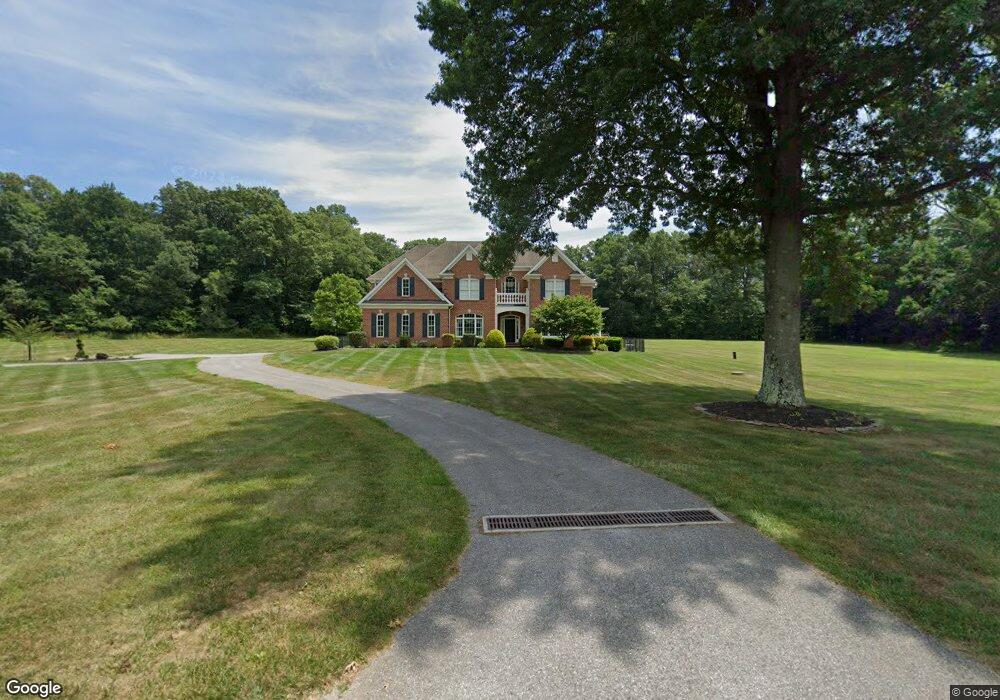
16937 Brose Rd New Freedom, PA 17349
Estimated Value: $646,000 - $862,677
4
Beds
4
Baths
3,400
Sq Ft
$222/Sq Ft
Est. Value
About This Home
This home is located at 16937 Brose Rd, New Freedom, PA 17349 and is currently estimated at $754,339, approximately $221 per square foot. 16937 Brose Rd is a home located in York County with nearby schools including Susquehannock High School and Shrewsbury Christian Academy.
Ownership History
Date
Name
Owned For
Owner Type
Purchase Details
Closed on
May 17, 2002
Sold by
Shaw John R and Shaw Sally A
Bought by
Rose Frank A and Rose Christina R
Current Estimated Value
Home Financials for this Owner
Home Financials are based on the most recent Mortgage that was taken out on this home.
Original Mortgage
$148,000
Outstanding Balance
$63,461
Interest Rate
7.15%
Estimated Equity
$690,878
Create a Home Valuation Report for This Property
The Home Valuation Report is an in-depth analysis detailing your home's value as well as a comparison with similar homes in the area
Home Values in the Area
Average Home Value in this Area
Purchase History
| Date | Buyer | Sale Price | Title Company |
|---|---|---|---|
| Rose Frank A | $185,000 | -- |
Source: Public Records
Mortgage History
| Date | Status | Borrower | Loan Amount |
|---|---|---|---|
| Open | Rose Frank A | $148,000 |
Source: Public Records
Tax History Compared to Growth
Tax History
| Year | Tax Paid | Tax Assessment Tax Assessment Total Assessment is a certain percentage of the fair market value that is determined by local assessors to be the total taxable value of land and additions on the property. | Land | Improvement |
|---|---|---|---|---|
| 2025 | $10,899 | $393,840 | $6,260 | $387,580 |
| 2024 | $10,588 | $393,840 | $6,260 | $387,580 |
| 2023 | $10,588 | $393,840 | $6,260 | $387,580 |
| 2022 | $10,588 | $393,840 | $6,260 | $387,580 |
| 2021 | $10,171 | $393,840 | $6,260 | $387,580 |
| 2020 | $10,171 | $393,840 | $6,260 | $387,580 |
| 2019 | $9,971 | $389,440 | $6,260 | $383,180 |
| 2018 | $9,788 | $389,440 | $6,260 | $383,180 |
| 2017 | $9,609 | $389,440 | $6,260 | $383,180 |
| 2016 | $0 | $389,440 | $6,260 | $383,180 |
| 2015 | -- | $388,870 | $5,690 | $383,180 |
| 2014 | -- | $388,350 | $5,170 | $383,180 |
Source: Public Records
Map
Nearby Homes
- 0 5 Forks Rd
- 3267 Davis Valley Rd
- 1568 Deer Creek Rd
- 0 Bridgeview Rd Unit PAYK2080146
- 671 Sunglow Dr
- 17181 Mount Airy Rd
- 17315 Kennebeck Ln
- 1689 Tolna Junction Ln
- 18061 Fielding Ct
- 653 Sunglow Dr
- 17318 Kennebeck Ln
- 524 Well Dr
- 17555 Snowden Terrace
- Lot #1 Norland Way Unit COVINGTON
- 1771 Blue Jay Ct
- 17796 Iron Bridge Rd
- Kipling Plan at Foxhaven
- Hawthorne Plan at Foxhaven
- Woodford Plan at Foxhaven
- Magnolia Plan at Foxhaven
- 1910 Bartenslager Rd
- 17194 Howard Ln
- 17197 Howard Ln
- 17191 Howard Ln
- 17171 Howard Ln
- 1859 Bartenslager Rd
- 1897 Southview Ct
- 16685 Brose Rd
- 1636 Deer Creek Rd
- 1842 Cooper Rd
- 1913 Southview Ct
- 1784 Deer Creek Rd
- 19881 Five Forks Rd
- 1675 Deer Creek Rd
- 19866 Five Forks Rd
- 19795 Five Forks Rd
- 19765 Five Forks Rd
- 17389 Brose Rd
- 19790 Five Forks Rd
- 19755 Five Forks Rd