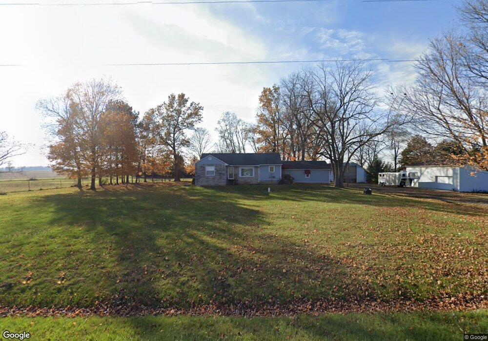
16953 State Route 117 Waynesfield, OH 45896
Estimated Value: $219,000 - $257,889
3
Beds
1
Bath
1,200
Sq Ft
$195/Sq Ft
Est. Value
About This Home
This home is located at 16953 State Route 117, Waynesfield, OH 45896 and is currently estimated at $234,222, approximately $195 per square foot. 16953 State Route 117 is a home with nearby schools including Upper Scioto Valley Elementary School, Upper Scioto Valley Middle School, and Upper Scioto Valley High School.
Ownership History
Date
Name
Owned For
Owner Type
Purchase Details
Closed on
Feb 22, 2013
Sold by
Wurst Joseph A and Wurst Letitia
Bought by
Rittenour Thomas Daryl and Preston Jessica Marie
Current Estimated Value
Home Financials for this Owner
Home Financials are based on the most recent Mortgage that was taken out on this home.
Original Mortgage
$146,300
Outstanding Balance
$101,940
Interest Rate
3.34%
Mortgage Type
New Conventional
Estimated Equity
$132,282
Purchase Details
Closed on
Mar 9, 2011
Sold by
Wurst Joseph A
Bought by
Wurst Joseph A and Wurst Letitia
Purchase Details
Closed on
Nov 13, 1998
Bought by
Wurst Joseph A
Create a Home Valuation Report for This Property
The Home Valuation Report is an in-depth analysis detailing your home's value as well as a comparison with similar homes in the area
Home Values in the Area
Average Home Value in this Area
Purchase History
| Date | Buyer | Sale Price | Title Company |
|---|---|---|---|
| Rittenour Thomas Daryl | $154,000 | None Available | |
| Wurst Joseph A | -- | None Available | |
| Wurst Joseph A | $67,500 | -- |
Source: Public Records
Mortgage History
| Date | Status | Borrower | Loan Amount |
|---|---|---|---|
| Open | Rittenour Thomas Daryl | $146,300 |
Source: Public Records
Tax History Compared to Growth
Tax History
| Year | Tax Paid | Tax Assessment Tax Assessment Total Assessment is a certain percentage of the fair market value that is determined by local assessors to be the total taxable value of land and additions on the property. | Land | Improvement |
|---|---|---|---|---|
| 2024 | $2,436 | $64,020 | $11,360 | $52,660 |
| 2023 | $2,436 | $64,020 | $11,360 | $52,660 |
| 2022 | $2,203 | $52,430 | $8,080 | $44,350 |
| 2021 | $2,323 | $52,430 | $8,080 | $44,350 |
| 2020 | $2,353 | $52,430 | $8,080 | $44,350 |
| 2019 | $1,935 | $46,660 | $7,860 | $38,800 |
| 2018 | $1,943 | $46,660 | $7,860 | $38,800 |
| 2017 | $1,915 | $46,660 | $7,860 | $38,800 |
| 2016 | $1,331 | $35,090 | $7,340 | $27,750 |
| 2015 | $1,276 | $35,090 | $7,340 | $27,750 |
| 2014 | $1,331 | $35,090 | $7,340 | $27,750 |
| 2013 | $1,339 | $33,580 | $7,340 | $26,240 |
Source: Public Records
Map
Nearby Homes
- 16949 Township Road 39
- 2444 County Road 200
- 16161 Ash Ave
- 16235 Maple Ave
- 15527 State Route 235
- 14918 Township Road 55
- 16074 Buckeye Ave
- 15858 Hickory Ave
- 15848 Barnes Dr
- 11262 Northlake Dr
- 11455 Oak St
- 10998 Township Road 293
- 11377 Township Rd 266 Unit 66
- 11377 Township Rd 266 Unit 30
- 11377 Township Rd 266 Unit 59
- 11377 Township Road 266 Unit 3
- 11377 Township Road 266 Unit 59
- 11377 Township Road 266 Unit 99
- 11377 Township Road 266 Unit 77
- 11377 Township Road 266 Unit 34
- 16882 State Route 117
- 16869 State Route 117
- 16805 State Route 117
- 1475 Township Road 180
- 1399 Township Road 180
- 17235 State Route 117
- 1337 Township Road 180
- 11195 Township Road 293 # 415
- XXX Sr 117
- 867 Tr 180
- 17226 State Route 235
- 17704 Ohio 117
- 17704 Ohio 117
- 16250 State Route 235
- 16098 Sr 235 N #3 Unit 3
- 1694 State Route 67
- 1488 State Route 67
- 17806 Sr 117
- 17803 State Route 117
- 17803 Ohio 117