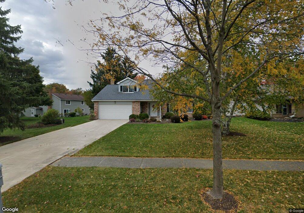
16963 Deer Path Dr Strongsville, OH 44136
Estimated Value: $363,000 - $393,000
4
Beds
3
Baths
2,481
Sq Ft
$152/Sq Ft
Est. Value
About This Home
This home is located at 16963 Deer Path Dr, Strongsville, OH 44136 and is currently estimated at $377,292, approximately $152 per square foot. 16963 Deer Path Dr is a home located in Cuyahoga County with nearby schools including Strongsville High School and Sts Joseph & John Interparochial School.
Ownership History
Date
Name
Owned For
Owner Type
Purchase Details
Closed on
Jan 30, 1986
Sold by
Dohallow Donald J
Bought by
Stauss John R and Stauss Mary J
Current Estimated Value
Purchase Details
Closed on
Dec 15, 1983
Sold by
Sobhi R Mankarious
Bought by
Dohallow Donald J
Purchase Details
Closed on
Apr 7, 1981
Sold by
Mankarious Sobhi R
Bought by
Sobhi R Mankarious
Purchase Details
Closed on
Mar 1, 1978
Sold by
Licursi Robert
Bought by
Mankarious Sobhi R
Purchase Details
Closed on
Mar 4, 1977
Bought by
Licursi Robert
Purchase Details
Closed on
Mar 31, 1976
Bought by
Chestnut Homes Of Strongs-
Purchase Details
Closed on
Mar 25, 1976
Bought by
Investors Development Co
Purchase Details
Closed on
Jan 1, 1976
Bought by
Erie Shores Dev Co Inc
Create a Home Valuation Report for This Property
The Home Valuation Report is an in-depth analysis detailing your home's value as well as a comparison with similar homes in the area
Home Values in the Area
Average Home Value in this Area
Purchase History
| Date | Buyer | Sale Price | Title Company |
|---|---|---|---|
| Stauss John R | $104,000 | -- | |
| Dohallow Donald J | $90,000 | -- | |
| Sobhi R Mankarious | -- | -- | |
| Mankarious Sobhi R | $78,000 | -- | |
| Licursi Robert | $75,000 | -- | |
| Chestnut Homes Of Strongs- | -- | -- | |
| Investors Development Co | $46,500 | -- | |
| Erie Shores Dev Co Inc | -- | -- |
Source: Public Records
Tax History Compared to Growth
Tax History
| Year | Tax Paid | Tax Assessment Tax Assessment Total Assessment is a certain percentage of the fair market value that is determined by local assessors to be the total taxable value of land and additions on the property. | Land | Improvement |
|---|---|---|---|---|
| 2024 | $4,798 | $112,000 | $19,600 | $92,400 |
| 2023 | $4,615 | $82,880 | $16,520 | $66,360 |
| 2022 | $4,608 | $82,880 | $16,520 | $66,360 |
| 2021 | $4,572 | $82,880 | $16,520 | $66,360 |
| 2020 | $4,126 | $67,940 | $13,550 | $54,390 |
| 2019 | $4,005 | $194,100 | $38,700 | $155,400 |
| 2018 | $3,635 | $67,940 | $13,550 | $54,390 |
| 2017 | $3,615 | $63,250 | $10,920 | $52,330 |
| 2016 | $3,586 | $63,250 | $10,920 | $52,330 |
| 2015 | $3,637 | $63,250 | $10,920 | $52,330 |
| 2014 | $3,637 | $63,250 | $10,920 | $52,330 |
Source: Public Records
Map
Nearby Homes
- 17024 Bear Creek Ln
- 18294 Drake Rd
- 17682 Drake Rd
- 17069 Partridge Dr
- 18162 Fawn Cir
- 17934 Cambridge Oval
- 17159 Turkey Meadow Ln
- 16650 Lanier Ave
- 18411 Yorktown Oval
- 19297 Lauren Way
- 17259 Woodshire Dr
- 19311 Bradford Ct
- 18630 Shurmer Rd
- 16486 S Red Rock Dr
- 20393 Wildwood Ln
- 16450 Howe Rd
- 18848 Pearl Rd
- 17130 Golden Star Dr
- 19908 Stoughton Dr
- 19513 Lunn Rd
- 16965 Deer Path Dr
- 16974 Stag Thicket Ln
- 16972 Stag Thicket Ln
- 16967 Deer Path Dr
- 16976 Stag Thicket Ln
- 16978 Stag Thicket Ln
- 16052 Squirrel Hollow Ln
- 16969 Deer Path Dr
- 16970 Stag Thicket Ln
- 16956 Deer Path Dr
- 16050 Squirrel Hollow Ln
- 16958 Deer Path Dr
- 16960 Deer Path Dr
- 16048 Squirrel Hollow Ln
- 16980 Stag Thicket Ln
- 16971 Deer Path Dr
- 16961 Deer Path Dr
- 16968 Stag Thicket Ln
- 16962 Deer Path Dr
- 16975 Stag Thicket Ln