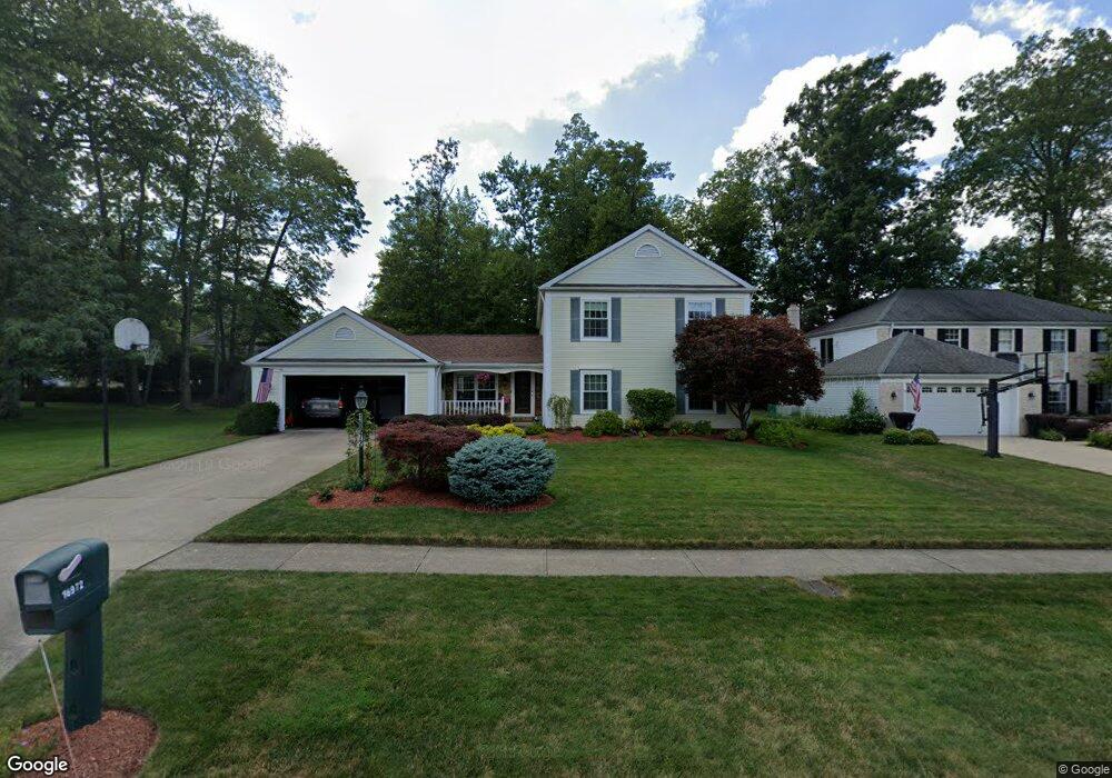
16972 S Meadows Cir Strongsville, OH 44136
Estimated Value: $378,734 - $444,000
4
Beds
3
Baths
2,522
Sq Ft
$160/Sq Ft
Est. Value
About This Home
This home is located at 16972 S Meadows Cir, Strongsville, OH 44136 and is currently estimated at $403,684, approximately $160 per square foot. 16972 S Meadows Cir is a home located in Cuyahoga County with nearby schools including Strongsville High School and Sts Joseph & John Interparochial School.
Ownership History
Date
Name
Owned For
Owner Type
Purchase Details
Closed on
Aug 14, 1986
Sold by
Tanquist Richard J and Tanquist Colette
Bought by
Honrot Jeffrey A
Current Estimated Value
Purchase Details
Closed on
Dec 16, 1982
Bought by
Tanquist Richard J and Tanquist Colette
Purchase Details
Closed on
Jul 7, 1981
Bought by
Howard B Schulman Trs
Purchase Details
Closed on
Jun 20, 1980
Bought by
Feiner Michael A - Trustee
Purchase Details
Closed on
Jan 1, 1977
Bought by
Parkview Corp
Create a Home Valuation Report for This Property
The Home Valuation Report is an in-depth analysis detailing your home's value as well as a comparison with similar homes in the area
Home Values in the Area
Average Home Value in this Area
Purchase History
| Date | Buyer | Sale Price | Title Company |
|---|---|---|---|
| Honrot Jeffrey A | $115,000 | -- | |
| Tanquist Richard J | -- | -- | |
| Howard B Schulman Trs | -- | -- | |
| Feiner Michael A - Trustee | $125,900 | -- | |
| Parkview Corp | -- | -- |
Source: Public Records
Tax History Compared to Growth
Tax History
| Year | Tax Paid | Tax Assessment Tax Assessment Total Assessment is a certain percentage of the fair market value that is determined by local assessors to be the total taxable value of land and additions on the property. | Land | Improvement |
|---|---|---|---|---|
| 2024 | $4,966 | $115,570 | $24,045 | $91,525 |
| 2023 | $5,297 | $84,600 | $20,370 | $64,230 |
| 2022 | $5,259 | $84,595 | $20,370 | $64,225 |
| 2021 | $5,217 | $84,600 | $20,370 | $64,230 |
| 2020 | $4,834 | $69,340 | $16,700 | $52,640 |
| 2019 | $4,692 | $198,100 | $47,700 | $150,400 |
| 2018 | $4,161 | $69,340 | $16,700 | $52,640 |
| 2017 | $4,140 | $62,410 | $13,480 | $48,930 |
| 2016 | $4,107 | $62,410 | $13,480 | $48,930 |
| 2015 | $4,165 | $62,410 | $13,480 | $48,930 |
| 2014 | $4,165 | $62,410 | $13,480 | $48,930 |
Source: Public Records
Map
Nearby Homes
- 16650 Lanier Ave
- 16969 Antler Ln
- 17084 Hampton Chase
- 17029 Eagles Nest Cir
- 0 Shurmer Rd Unit 5108190
- 17069 Partridge Dr
- 17159 Turkey Meadow Ln
- 16667 Drake Rd
- 18162 Fawn Cir
- 17682 Drake Rd
- 14826 Lenox Dr
- 14703 Lenox Dr Unit 103
- 18630 Shurmer Rd
- 18229 Howe Rd
- 18411 Yorktown Oval
- 19297 Lauren Way
- 0 Mill Hollow Ln Unit 5069608
- 19445 Lunn Rd
- 14558 Drake Rd
- 18323 Benbow Rd
- 16964 S Meadows Cir
- 16996 S Meadows Cir
- 16980 S Meadows Cir
- 16957 Hunting Meadows Dr
- 16956 S Meadows Cir
- 17004 S Meadows Cir
- 16947 S Meadows Cir
- 16965 Hunting Meadows Dr
- 16939 S Meadows Cir
- 16955 S Meadows Cir
- 16931 S Meadows Cir
- 16973 Hunting Meadows Dr
- 16963 S Meadows Cir
- 17012 S Meadows Cir
- 16987 S Meadows Cir
- 16923 S Meadows Cir
- 16995 S Meadows Cir
- 16979 S Meadows Cir
- 16979 S Meadows Cir
- 16960 N Meadows Cir