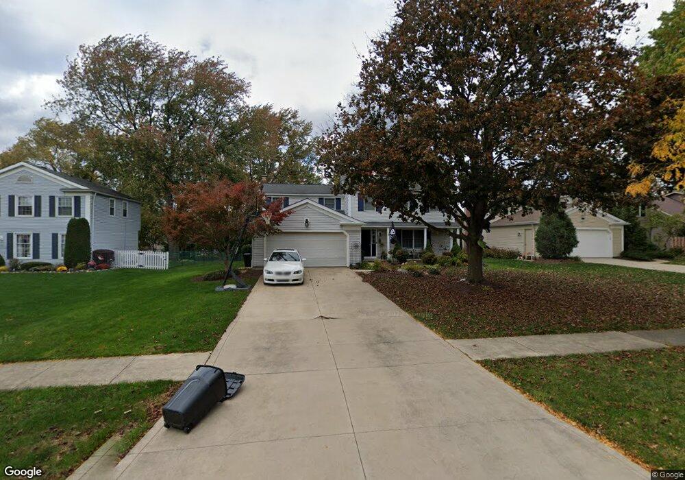
16973 Deer Path Dr Strongsville, OH 44136
Estimated Value: $334,538 - $376,000
4
Beds
3
Baths
2,056
Sq Ft
$176/Sq Ft
Est. Value
About This Home
This home is located at 16973 Deer Path Dr, Strongsville, OH 44136 and is currently estimated at $361,385, approximately $175 per square foot. 16973 Deer Path Dr is a home located in Cuyahoga County with nearby schools including Strongsville High School and Sts Joseph & John Interparochial School.
Ownership History
Date
Name
Owned For
Owner Type
Purchase Details
Closed on
Feb 24, 2024
Sold by
Polomsky Benard
Bought by
Polomsky Benard and Carameli Kelley A
Current Estimated Value
Purchase Details
Closed on
Apr 14, 2023
Sold by
Polomsky Heather
Bought by
Polomsky Bernard
Purchase Details
Closed on
Jul 12, 2005
Sold by
Airel Gregory G and Airel Mary R
Bought by
Polomsky Bernard and Polomsky Heather
Home Financials for this Owner
Home Financials are based on the most recent Mortgage that was taken out on this home.
Original Mortgage
$120,000
Interest Rate
5.69%
Mortgage Type
Purchase Money Mortgage
Purchase Details
Closed on
Sep 2, 1986
Sold by
John A Slane
Bought by
Airel Gregory G
Purchase Details
Closed on
May 15, 1980
Sold by
Slane John A
Bought by
John A Slane
Purchase Details
Closed on
Jul 29, 1976
Bought by
Slane John A
Purchase Details
Closed on
Jan 1, 1976
Bought by
J D Land Co
Create a Home Valuation Report for This Property
The Home Valuation Report is an in-depth analysis detailing your home's value as well as a comparison with similar homes in the area
Home Values in the Area
Average Home Value in this Area
Purchase History
| Date | Buyer | Sale Price | Title Company |
|---|---|---|---|
| Polomsky Benard | -- | None Listed On Document | |
| Polomsky Bernard | $113,250 | Ohio Real Title | |
| Polomsky Bernard | $206,000 | Chicago Title Insurance C | |
| Airel Gregory G | $98,500 | -- | |
| John A Slane | -- | -- | |
| Slane John A | $62,400 | -- | |
| J D Land Co | -- | -- |
Source: Public Records
Mortgage History
| Date | Status | Borrower | Loan Amount |
|---|---|---|---|
| Previous Owner | Polomsky Bernard | $120,000 |
Source: Public Records
Tax History Compared to Growth
Tax History
| Year | Tax Paid | Tax Assessment Tax Assessment Total Assessment is a certain percentage of the fair market value that is determined by local assessors to be the total taxable value of land and additions on the property. | Land | Improvement |
|---|---|---|---|---|
| 2024 | $4,856 | $103,425 | $22,400 | $81,025 |
| 2023 | $4,964 | $79,280 | $18,900 | $60,380 |
| 2022 | $4,928 | $226,500 | $54,000 | $172,500 |
| 2021 | $4,889 | $79,280 | $18,900 | $60,380 |
| 2020 | $4,531 | $65,000 | $15,510 | $49,490 |
| 2019 | $4,398 | $185,700 | $44,300 | $141,400 |
| 2018 | $3,992 | $65,000 | $15,510 | $49,490 |
| 2017 | $3,994 | $60,210 | $12,500 | $47,710 |
| 2016 | $3,962 | $60,210 | $12,500 | $47,710 |
| 2015 | $4,018 | $60,210 | $12,500 | $47,710 |
| 2014 | $4,018 | $60,210 | $12,500 | $47,710 |
Source: Public Records
Map
Nearby Homes
- 17024 Bear Creek Ln
- 17069 Partridge Dr
- 17682 Drake Rd
- 18162 Fawn Cir
- 18294 Drake Rd
- 17159 Turkey Meadow Ln
- 17934 Cambridge Oval
- 16650 Lanier Ave
- 19311 Bradford Ct
- 19297 Lauren Way
- 18411 Yorktown Oval
- 17259 Woodshire Dr
- 18630 Shurmer Rd
- 16486 S Red Rock Dr
- 16450 Howe Rd
- 17130 Golden Star Dr
- 20393 Wildwood Ln
- 15639 Indianhead Ln
- 19513 Lunn Rd
- 18848 Pearl Rd
- 16971 Deer Path Dr
- 16975 Deer Path Dr
- 16969 Deer Path Dr
- 16977 Deer Path Dr
- 16044 Squirrel Hollow Ln
- 16042 Squirrel Hollow Ln
- 16046 Squirrel Hollow Ln
- 16979 Deer Path Dr
- 16967 Deer Path Dr
- 16966 Deer Path Dr
- 16040 Squirrel Hollow Ln
- 16048 Squirrel Hollow Ln
- 16968 Deer Path Dr
- 16964 Deer Path Dr
- 16963 Bear Creek Ln
- 16962 Deer Path Dr
- 16981 Deer Path Dr
- 16965 Deer Path Dr
- 16050 Squirrel Hollow Ln
- 16038 Squirrel Hollow Ln