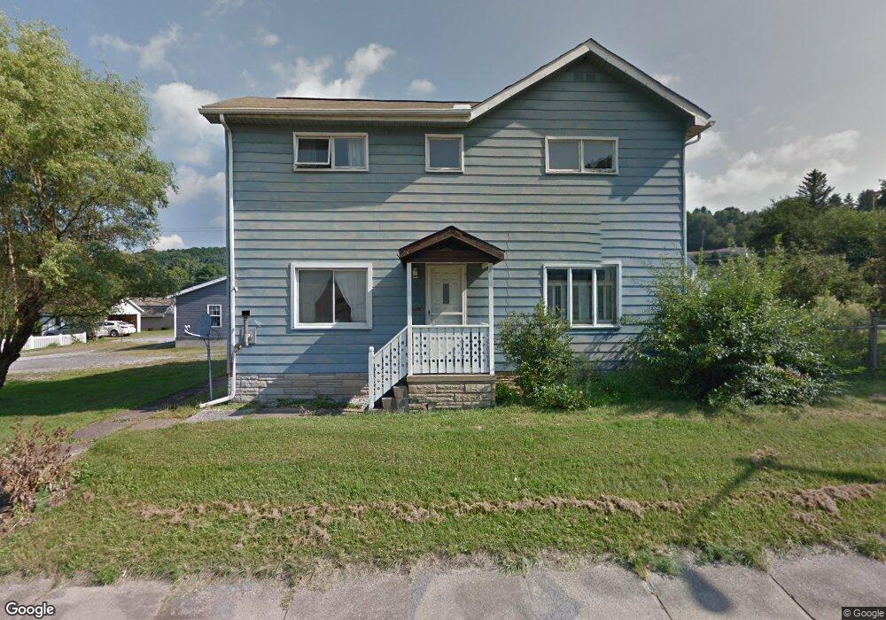
1699 Main St Brockway, PA 15824
Estimated Value: $133,253 - $180,000
--
Bed
--
Bath
938
Sq Ft
$164/Sq Ft
Est. Value
About This Home
This home is located at 1699 Main St, Brockway, PA 15824 and is currently estimated at $154,063, approximately $164 per square foot. 1699 Main St is a home located in Jefferson County with nearby schools including Brockway Area Elementary School, Brockway Area Junior/Senior High School, and Hillside School.
Ownership History
Date
Name
Owned For
Owner Type
Purchase Details
Closed on
Aug 9, 2021
Sold by
Martell Mark A and Martell Kimberly M
Bought by
Knarr Ryan M and Knarr Rebekah
Current Estimated Value
Home Financials for this Owner
Home Financials are based on the most recent Mortgage that was taken out on this home.
Original Mortgage
$108,007
Outstanding Balance
$98,064
Interest Rate
2.8%
Mortgage Type
FHA
Estimated Equity
$55,999
Purchase Details
Closed on
Feb 16, 2005
Sold by
Perrin Kendall E and Perrin Holly H
Bought by
Martell Mark A and Martell Kimberly M
Home Financials for this Owner
Home Financials are based on the most recent Mortgage that was taken out on this home.
Original Mortgage
$58,500
Interest Rate
5.55%
Mortgage Type
Assumption
Create a Home Valuation Report for This Property
The Home Valuation Report is an in-depth analysis detailing your home's value as well as a comparison with similar homes in the area
Home Values in the Area
Average Home Value in this Area
Purchase History
| Date | Buyer | Sale Price | Title Company |
|---|---|---|---|
| Knarr Ryan M | $110,000 | None Available | |
| Martell Mark A | $57,000 | None Available |
Source: Public Records
Mortgage History
| Date | Status | Borrower | Loan Amount |
|---|---|---|---|
| Open | Knarr Ryan M | $108,007 | |
| Previous Owner | Martell Mark A | $58,500 |
Source: Public Records
Tax History Compared to Growth
Tax History
| Year | Tax Paid | Tax Assessment Tax Assessment Total Assessment is a certain percentage of the fair market value that is determined by local assessors to be the total taxable value of land and additions on the property. | Land | Improvement |
|---|---|---|---|---|
| 2025 | $2,287 | $48,300 | $9,930 | $38,370 |
| 2024 | $2,610 | $48,300 | $9,930 | $38,370 |
| 2023 | $2,239 | $48,300 | $9,930 | $38,370 |
| 2022 | $2,239 | $48,300 | $9,930 | $38,370 |
| 2021 | $2,239 | $48,300 | $9,930 | $38,370 |
| 2020 | $3,146 | $67,870 | $9,930 | $57,940 |
| 2019 | $3,035 | $67,870 | $9,930 | $57,940 |
| 2018 | $2,903 | $67,870 | $9,930 | $57,940 |
| 2017 | $2,866 | $67,870 | $9,930 | $57,940 |
| 2016 | $2,664 | $67,870 | $9,930 | $57,940 |
| 2015 | -- | $69,870 | $9,930 | $59,940 |
| 2012 | -- | $64,100 | $9,930 | $54,170 |
Source: Public Records
Map
Nearby Homes
- 924 Elm St
- 1549 Main St
- 0 U S 219
- 1074 10th Ave
- 970 Baghdad Rd
- 425 Zuccolotto Ln
- 7956 U S 219
- 1083 Rattlesnake Rd
- 19 Salandra Ln
- 101 Howard Rd
- 5850 U S 219
- 390 Galliot Ct
- 0 Cap Haitien Rd Unit SEC 17 LOT 14
- 636 Cap Haitien Rd
- Section 14 Lot 24 Port-Au-prince Rd
- 14 Port-Au-prince Rd
- 579 Codrington Rd
- 580 Codrington Rd
- 13 Cap Haitien Rd
- 5546 Stevenson Hill Rd