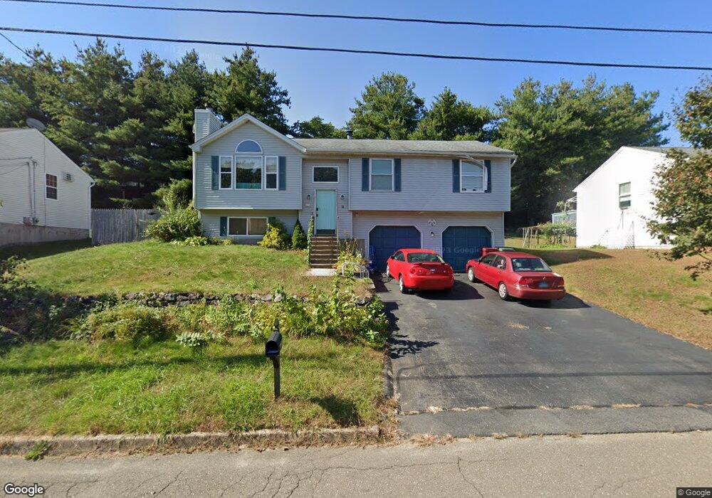
17 Brittany Ln Naugatuck, CT 06770
Estimated Value: $376,308 - $409,000
3
Beds
2
Baths
1,190
Sq Ft
$329/Sq Ft
Est. Value
About This Home
This home is located at 17 Brittany Ln, Naugatuck, CT 06770 and is currently estimated at $391,827, approximately $329 per square foot. 17 Brittany Ln is a home located in New Haven County with nearby schools including City Hill Middle School and Naugatuck High School.
Ownership History
Date
Name
Owned For
Owner Type
Purchase Details
Closed on
Sep 29, 2017
Sold by
Brackett Debra
Bought by
Brackett Walter
Current Estimated Value
Purchase Details
Closed on
Jan 2, 2013
Sold by
Brackett Walter S
Bought by
Brackett Walter S and Brackett Debra
Purchase Details
Closed on
Jun 20, 1994
Sold by
Vc Rlty
Bought by
Brackett Walter and Brackett Karen
Create a Home Valuation Report for This Property
The Home Valuation Report is an in-depth analysis detailing your home's value as well as a comparison with similar homes in the area
Home Values in the Area
Average Home Value in this Area
Purchase History
| Date | Buyer | Sale Price | Title Company |
|---|---|---|---|
| Brackett Walter | -- | -- | |
| Brackett Walter S | -- | -- | |
| Brackett Walter | $139,000 | -- |
Source: Public Records
Mortgage History
| Date | Status | Borrower | Loan Amount |
|---|---|---|---|
| Open | Brackett Walter | $164,000 | |
| Previous Owner | Brackett Walter | $164,326 | |
| Previous Owner | Brackett Walter | $141,600 |
Source: Public Records
Tax History Compared to Growth
Tax History
| Year | Tax Paid | Tax Assessment Tax Assessment Total Assessment is a certain percentage of the fair market value that is determined by local assessors to be the total taxable value of land and additions on the property. | Land | Improvement |
|---|---|---|---|---|
| 2025 | $7,175 | $180,320 | $30,030 | $150,290 |
| 2024 | $7,536 | $180,320 | $30,030 | $150,290 |
| 2023 | $8,069 | $180,320 | $30,030 | $150,290 |
| 2022 | $6,848 | $143,420 | $33,120 | $110,300 |
| 2021 | $6,848 | $143,420 | $33,120 | $110,300 |
| 2020 | $6,848 | $143,420 | $33,120 | $110,300 |
| 2019 | $6,777 | $143,420 | $33,120 | $110,300 |
| 2018 | $6,528 | $135,020 | $46,680 | $88,340 |
| 2017 | $6,555 | $135,020 | $46,680 | $88,340 |
| 2016 | $6,436 | $135,020 | $46,680 | $88,340 |
| 2015 | $6,153 | $135,020 | $46,680 | $88,340 |
| 2014 | $6,084 | $135,020 | $46,680 | $88,340 |
| 2012 | $5,686 | $169,470 | $50,740 | $118,730 |
Source: Public Records
Map
Nearby Homes
- 29 Ramsey Ave
- 219 Union City Rd
- 223 E Waterbury Rd
- 333 Wooster St
- 21 Acushnet St
- 92 Quentin St
- 465 N Main St
- 38 Tyler Hill Rd
- 142 Applewood Ln
- 69 Nancy Ln
- 11 Shadee Ln
- 66 Nancy Ln
- 317 City Hill St
- 32 Greenwood St
- 111 Mallane Ln Unit 19A
- 51 Brook St Unit 7A
- 51 Brook St Unit 6A
- 92A Thunderbird Dr
- 17 Meadowbrook Dr
- 20 Charlene Dr
- 13 Brittany Ln
- 21 Brittany Ln
- 60 Marsh Hill Rd
- 56 Marsh Hill Rd
- 64 Marsh Hill Rd
- 9 Brittany Ln
- 27 Brittany Ln
- 52 Marsh Hill Rd
- 16 Brittany Ln
- 20 Brittany Ln
- 10 Brittany Ln
- 66 Marsh Hill Rd
- 24 Brittany Ln
- 48 Marsh Hill Rd
- 57 Marsh Hill Rd
- 7 Brittany Ln
- 63 Marsh Hill Rd
- 28 Brittany Ln
- 6 Brittany Ln
- 38 David St