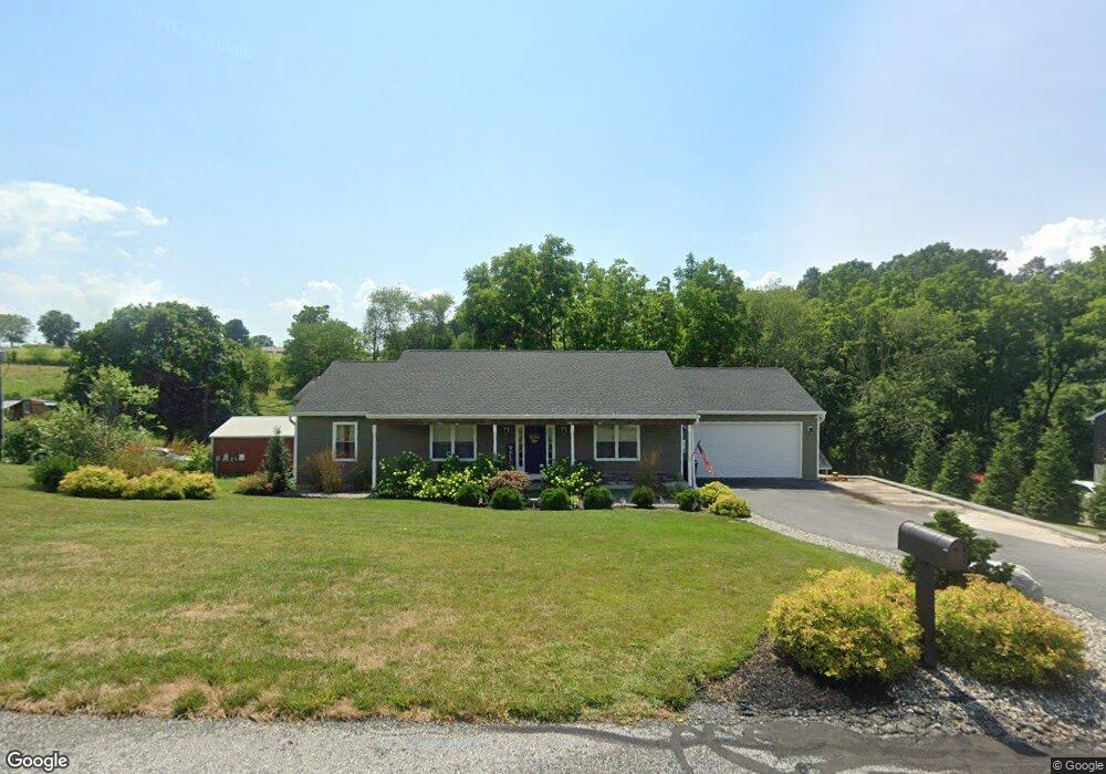
17 Burns Rd S Spring Grove, PA 17362
Estimated Value: $312,000 - $374,000
3
Beds
2
Baths
1,456
Sq Ft
$238/Sq Ft
Est. Value
About This Home
This home is located at 17 Burns Rd S, Spring Grove, PA 17362 and is currently estimated at $346,042, approximately $237 per square foot. 17 Burns Rd S is a home located in York County with nearby schools including Spring Grove Area Middle School and Spring Grove Area High School.
Ownership History
Date
Name
Owned For
Owner Type
Purchase Details
Closed on
Nov 5, 2019
Sold by
Spangler Thomas F and Spangler Thomas L
Bought by
Linden Janine Marie
Current Estimated Value
Home Financials for this Owner
Home Financials are based on the most recent Mortgage that was taken out on this home.
Original Mortgage
$113,925
Outstanding Balance
$100,225
Interest Rate
3.6%
Mortgage Type
New Conventional
Estimated Equity
$245,817
Purchase Details
Closed on
Jul 28, 2004
Sold by
Lookenbill Edward D and Lookenbill Louise E
Bought by
Spanger Thomas
Create a Home Valuation Report for This Property
The Home Valuation Report is an in-depth analysis detailing your home's value as well as a comparison with similar homes in the area
Home Values in the Area
Average Home Value in this Area
Purchase History
| Date | Buyer | Sale Price | Title Company |
|---|---|---|---|
| Linden Janine Marie | $245,000 | Regal Abstract Lancaster | |
| Spanger Thomas | $36,000 | -- |
Source: Public Records
Mortgage History
| Date | Status | Borrower | Loan Amount |
|---|---|---|---|
| Open | Linden Janine Marie | $113,925 |
Source: Public Records
Tax History Compared to Growth
Tax History
| Year | Tax Paid | Tax Assessment Tax Assessment Total Assessment is a certain percentage of the fair market value that is determined by local assessors to be the total taxable value of land and additions on the property. | Land | Improvement |
|---|---|---|---|---|
| 2025 | $6,247 | $174,230 | $33,020 | $141,210 |
| 2024 | $6,184 | $174,230 | $33,020 | $141,210 |
| 2023 | $5,884 | $165,790 | $33,020 | $132,770 |
| 2022 | $5,884 | $165,790 | $33,020 | $132,770 |
| 2021 | $5,648 | $165,790 | $33,020 | $132,770 |
| 2020 | $5,648 | $165,790 | $33,020 | $132,770 |
| 2019 | $828 | $24,790 | $24,790 | $0 |
| 2018 | $818 | $24,790 | $24,790 | $0 |
| 2017 | $800 | $24,790 | $24,790 | $0 |
| 2016 | $0 | $24,790 | $24,790 | $0 |
| 2015 | -- | $24,790 | $24,790 | $0 |
| 2014 | -- | $24,790 | $24,790 | $0 |
Source: Public Records
Map
Nearby Homes
- 0 Black Cherry Plan at Hills at Valley View Unit PAYK2082012
- 0 Willow Plan at Hills at Valley View Unit PAYK2082084
- 0 Redbud Plan at Hills at Valley View Unit PAYK2082078
- 6320 Liam Dr
- Emily Plan at Hills at Valley View
- Pin Oak Plan at Hills at Valley View
- Black Cherry Plan at Hills at Valley View
- Sassafras Plan at Hills at Valley View
- Sweet Birch Plan at Hills at Valley View
- Redbud Plan at Hills at Valley View
- Willow Plan at Hills at Valley View
- White Oak Plan at Hills at Valley View
- Sugar Maple Plan at Hills at Valley View
- 0 Pin Oak Plan at Hills at Valley View Unit PAYK2082014
- 0 Sweet Birch Plan at Hills at Valley View Unit PAYK2082022
- 0 Emily Plan at Hills at Valley View Unit PAYK2082076
- 0 White Oak Plan at Hills at Valley View Unit PAYK2082080
- 0 Pin Oak 5br Plan at Hills at Valley View Unit PAYK2087614
- 6324 Liam
- 0 Sugar Maple Plan at Hills at Valley View Unit PAYK2082020
- 0 Burns Rd S Unit PAYK114370
- 28 Burns Rd
- 17 Burns Rd
- 26 Burns Rd
- 30 Burns Rd
- 19 Burns Rd
- 24 Burns Rd
- 23 Burns Rd
- 3563 Hardwood Terrace
- 22 Burns Rd
- 3554 Hardwood Terrace
- 15 S Burns Rd
- 25 Burns Rd
- 3561 Hardwood Terrace
- 3552 Hardwood Terrace
- 20 S Burns Rd
- 18 S Burns Rd
- 3559 Hardwood Terrace
- 3550 Hardwood Terrace
- 18 Burns Rd