Estimated Value: $568,000 - $661,000
3
Beds
3
Baths
2,124
Sq Ft
$285/Sq Ft
Est. Value
About This Home
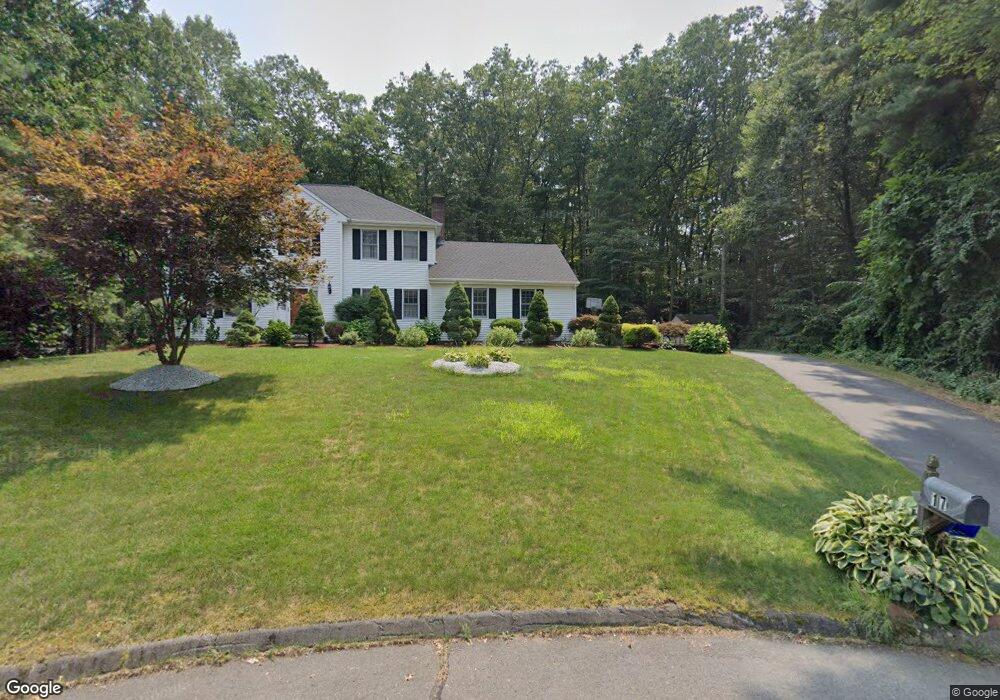
This home is located at 17 Canfield Way, Avon, CT 06001 and is currently estimated at $605,509, approximately $285 per square foot. 17 Canfield Way is a home located in Hartford County with nearby schools including Roaring Brook School, Thompson Brook School, and Avon Middle School.
Ownership History
Date
Name
Owned For
Owner Type
Purchase Details
Closed on
Apr 8, 2002
Sold by
Lawson John A and Lawson Vicky
Bought by
Bempong Comfort and Bempong Lawrence A
Current Estimated Value
Home Financials for this Owner
Home Financials are based on the most recent Mortgage that was taken out on this home.
Original Mortgage
$260,000
Outstanding Balance
$108,090
Interest Rate
6.85%
Estimated Equity
$497,419
Purchase Details
Closed on
Aug 27, 1997
Sold by
Bromberg Ileen
Bought by
Lawson John and Lawson Vicky
Purchase Details
Closed on
Jan 10, 1994
Sold by
Zirakian Carol
Bought by
Bromberg Ilene
Create a Home Valuation Report for This Property
The Home Valuation Report is an in-depth analysis detailing your home's value as well as a comparison with similar homes in the area
Home Values in the Area
Average Home Value in this Area
Purchase History
| Date | Buyer | Sale Price | Title Company |
|---|---|---|---|
| Bempong Comfort | $325,000 | -- | |
| Bempong Comfort | $325,000 | -- | |
| Lawson John | $248,500 | -- | |
| Lawson John | $248,500 | -- | |
| Bromberg Ilene | $226,550 | -- | |
| Bromberg Ilene | $226,550 | -- |
Source: Public Records
Mortgage History
| Date | Status | Borrower | Loan Amount |
|---|---|---|---|
| Open | Bromberg Ilene | $260,000 | |
| Closed | Bromberg Ilene | $260,000 | |
| Previous Owner | Bromberg Ilene | $116,000 |
Source: Public Records
Tax History Compared to Growth
Tax History
| Year | Tax Paid | Tax Assessment Tax Assessment Total Assessment is a certain percentage of the fair market value that is determined by local assessors to be the total taxable value of land and additions on the property. | Land | Improvement |
|---|---|---|---|---|
| 2025 | $8,699 | $282,890 | $94,920 | $187,970 |
| 2024 | $8,391 | $282,890 | $94,920 | $187,970 |
| 2023 | $8,859 | $250,320 | $94,920 | $155,400 |
| 2022 | $8,664 | $250,320 | $94,920 | $155,400 |
| 2021 | $8,563 | $250,320 | $94,920 | $155,400 |
| 2020 | $8,236 | $250,320 | $94,920 | $155,400 |
| 2019 | $8,236 | $250,320 | $94,920 | $155,400 |
| 2018 | $7,961 | $253,940 | $94,920 | $159,020 |
| 2017 | $7,768 | $253,940 | $94,920 | $159,020 |
| 2016 | $7,496 | $253,940 | $94,920 | $159,020 |
| 2015 | $7,313 | $253,940 | $94,920 | $159,020 |
| 2014 | $7,192 | $253,940 | $94,920 | $159,020 |
Source: Public Records
Map
Nearby Homes
- 4 Orchard Farms Ln
- 3 Putnam Ln Unit 3
- 94 Sanford Ave
- 6 Redwood Ln Unit 6
- 115 W Avon Rd
- 5 Homestead Ln
- 159 Haynes Rd
- 10 Taine Mountain Rd
- 2 Muirfield Ln
- 9 Sedgewood Rd
- 148 River Rd
- 8919 Taine Mountain Rd
- 40 Homestead Ln
- 57 New Britain Ave Unit 59
- 33 Forge Dr
- 55 Depot Place
- 40 Donna Dr
- 3 Jordan Ln
- 34 Forest St
- 16 Chevas Rd