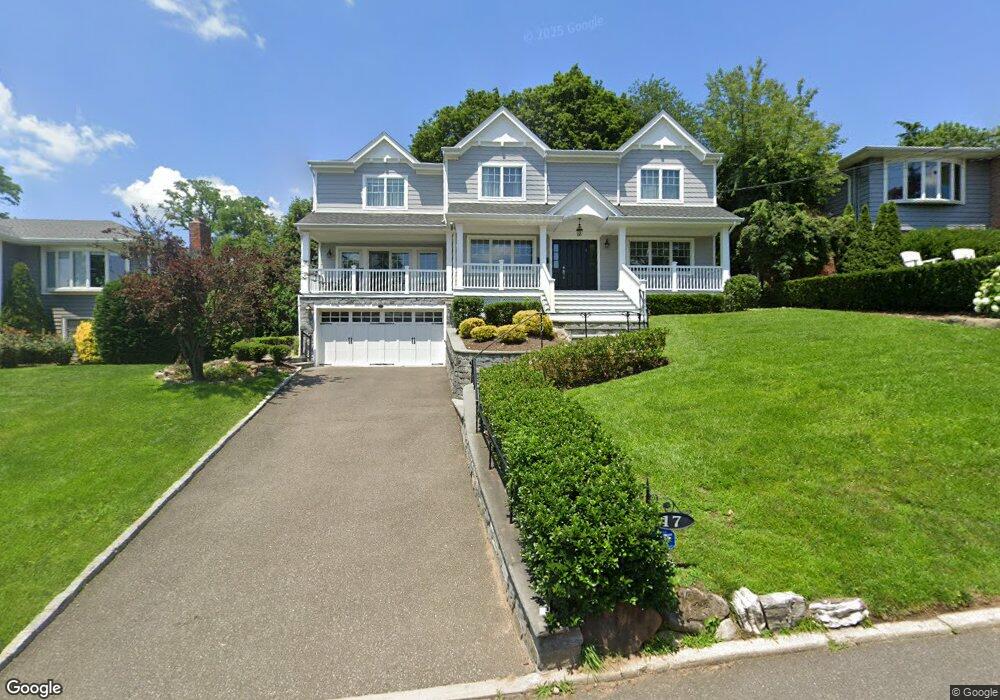
17 Capi Ln Port Washington, NY 11050
Estimated Value: $2,311,055
--
Bed
3
Baths
3,096
Sq Ft
$746/Sq Ft
Est. Value
About This Home
This home is located at 17 Capi Ln, Port Washington, NY 11050 and is currently estimated at $2,311,055, approximately $746 per square foot. 17 Capi Ln is a home located in Nassau County with nearby schools including John Philip Sousa Elementary School, Carrie Palmer Weber Middle School, and Paul D. Schreiber Senior High School.
Ownership History
Date
Name
Owned For
Owner Type
Purchase Details
Closed on
Apr 20, 2022
Sold by
Steinberg Laurel Minzer
Bought by
Saxe Keith and Saxe Gila
Current Estimated Value
Purchase Details
Closed on
Jun 19, 2018
Sold by
Samsons Builders Corp
Bought by
Steinberg Laurel Minzer
Purchase Details
Closed on
Oct 2, 2017
Sold by
Dorane James
Bought by
Samsons Builders Corp
Purchase Details
Closed on
Aug 29, 2017
Sold by
Wat James K and Wat Miranda K
Bought by
Dorane James
Purchase Details
Closed on
Dec 29, 1998
Purchase Details
Closed on
Dec 16, 1996
Create a Home Valuation Report for This Property
The Home Valuation Report is an in-depth analysis detailing your home's value as well as a comparison with similar homes in the area
Home Values in the Area
Average Home Value in this Area
Purchase History
| Date | Buyer | Sale Price | Title Company |
|---|---|---|---|
| Saxe Keith | $2,334,000 | Ultimate Abstract Of Ny Inc | |
| Steinberg Laurel Minzer | $1,901,644 | None Available | |
| Samsons Builders Corp | -- | Stewart Title | |
| Dorane James | $887,000 | East Coast Abstract Inc | |
| -- | -- | -- | |
| -- | -- | -- |
Source: Public Records
Tax History Compared to Growth
Tax History
| Year | Tax Paid | Tax Assessment Tax Assessment Total Assessment is a certain percentage of the fair market value that is determined by local assessors to be the total taxable value of land and additions on the property. | Land | Improvement |
|---|---|---|---|---|
| 2025 | $31,140 | $1,391 | $530 | $861 |
| 2024 | $9,405 | $1,391 | $530 | $861 |
| 2023 | $27,424 | $1,391 | $530 | $861 |
| 2022 | $27,424 | $1,391 | $530 | $861 |
| 2021 | $26,344 | $1,564 | $573 | $991 |
| 2020 | $29,711 | $2,130 | $1,325 | $805 |
| 2019 | $25,119 | $2,024 | $1,325 | $699 |
| 2018 | $25,119 | $2,024 | $0 | $0 |
| 2017 | $15,499 | $2,024 | $1,325 | $699 |
| 2016 | $23,824 | $2,024 | $1,325 | $699 |
| 2015 | $8,010 | $2,024 | $1,325 | $699 |
| 2014 | $8,010 | $2,024 | $1,325 | $699 |
| 2013 | $7,523 | $2,024 | $1,325 | $699 |
Source: Public Records
Map
Nearby Homes
- 0 Route 5 & 20
- 454 Main St
- 1 Luquer Rd
- 47 Carlton Ave
- 96 Davis Rd
- 28 Charles St
- 372 Main St Unit 105
- 2 Smull Ln
- 74 Bayview Ave Unit A
- 18 S Washington St
- 38 Madison St Unit 38L
- 43 Amherst Rd
- 17 Willow Dr
- 100 Gristmill Ln
- 113 Murray Ave
- 1 Toms Point Ln Unit Bldg.2, Apt.4A
- 34 Davis Rd
- 22 Franklin Ave
- 125 Main St Unit 1T
- 125 Main St Unit 2H