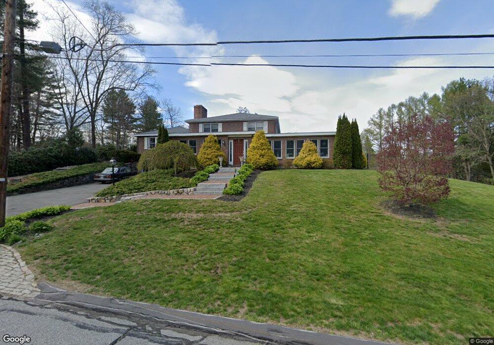
17 Clarence Rd Wayland, MA 01778
Estimated Value: $1,648,195 - $1,840,000
4
Beds
4
Baths
4,780
Sq Ft
$365/Sq Ft
Est. Value
About This Home
This home is located at 17 Clarence Rd, Wayland, MA 01778 and is currently estimated at $1,745,549, approximately $365 per square foot. 17 Clarence Rd is a home located in Middlesex County with nearby schools including Wayland High School and Veritas Christian Academy.
Ownership History
Date
Name
Owned For
Owner Type
Purchase Details
Closed on
Feb 16, 2010
Sold by
17 Clarence Road Rt and Odriscoll
Bought by
Odriscoll Denis and Odriscoll Sally A
Current Estimated Value
Home Financials for this Owner
Home Financials are based on the most recent Mortgage that was taken out on this home.
Original Mortgage
$180,500
Outstanding Balance
$119,527
Interest Rate
5.12%
Mortgage Type
Purchase Money Mortgage
Estimated Equity
$1,626,022
Purchase Details
Closed on
Aug 22, 2006
Sold by
Odriscoll Denis and Odriscoll Sally Ann
Bought by
17 Clarence Road Rt
Purchase Details
Closed on
Jan 25, 2005
Sold by
Odriscoll Denis and Odriscoll Sally A
Bought by
Odriscoll Denis G
Create a Home Valuation Report for This Property
The Home Valuation Report is an in-depth analysis detailing your home's value as well as a comparison with similar homes in the area
Home Values in the Area
Average Home Value in this Area
Purchase History
| Date | Buyer | Sale Price | Title Company |
|---|---|---|---|
| Odriscoll Denis | -- | -- | |
| Odriscoll Denis | -- | -- | |
| 17 Clarence Road Rt | -- | -- | |
| Odriscoll Denis G | -- | -- | |
| Odriscoll Denis | -- | -- | |
| 17 Clarence Road Rt | -- | -- | |
| Odriscoll Denis G | -- | -- |
Source: Public Records
Mortgage History
| Date | Status | Borrower | Loan Amount |
|---|---|---|---|
| Open | Odriscoll Denis | $180,500 | |
| Closed | Odriscoll Denis G | $180,500 | |
| Previous Owner | Odriscoll Denis G | $275,000 |
Source: Public Records
Tax History Compared to Growth
Tax History
| Year | Tax Paid | Tax Assessment Tax Assessment Total Assessment is a certain percentage of the fair market value that is determined by local assessors to be the total taxable value of land and additions on the property. | Land | Improvement |
|---|---|---|---|---|
| 2025 | $21,418 | $1,370,300 | $602,700 | $767,600 |
| 2024 | $20,305 | $1,308,300 | $574,200 | $734,100 |
| 2023 | $19,670 | $1,181,400 | $521,900 | $659,500 |
| 2022 | $19,071 | $1,039,300 | $432,000 | $607,300 |
| 2021 | $18,176 | $981,400 | $392,700 | $588,700 |
| 2020 | $17,694 | $996,300 | $392,700 | $603,600 |
| 2019 | $17,538 | $959,400 | $374,100 | $585,300 |
| 2018 | $15,522 | $860,900 | $374,100 | $486,800 |
| 2017 | $15,281 | $842,400 | $363,000 | $479,400 |
| 2016 | $14,103 | $813,300 | $356,000 | $457,300 |
| 2015 | $14,752 | $802,200 | $356,000 | $446,200 |
Source: Public Records
Map
Nearby Homes
- 47 Pequot Rd
- 37 Pequot Rd
- 353 Old Connecticut Path
- 208 Cochituate Rd
- 22 Lakeshore Dr
- 35 Wallace Rd
- 96 Lakeshore Dr
- 96 Lake Shore Dr
- 7 Shaw Dr
- 260 Cochituate Rd
- 108 Dudley Rd
- 123 Dudley Rd
- 26 Dudley Rd
- 15 Crest Rd
- 454 Old Connecticut Path
- 233 Lakeshore Dr
- 3 Keith Rd
- 28 Joyce Rd
- 2 Forest Hill Rd
- 5 Brook Trail Rd