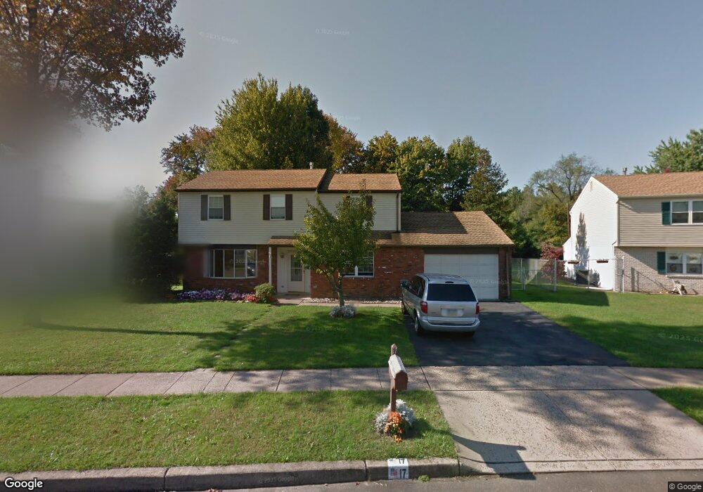
17 Dawn Rd Levittown, PA 19056
Estimated Value: $494,000 - $530,000
4
Beds
3
Baths
2,028
Sq Ft
$251/Sq Ft
Est. Value
About This Home
This home is located at 17 Dawn Rd, Levittown, PA 19056 and is currently estimated at $509,924, approximately $251 per square foot. 17 Dawn Rd is a home located in Bucks County with nearby schools including Albert Schweitzer Elementary School, Sandburg Middle School, and Neshaminy High School.
Ownership History
Date
Name
Owned For
Owner Type
Purchase Details
Closed on
Oct 28, 1997
Sold by
Reed Robert R and Reed Margaret E
Bought by
Kriger Harry and Kriger Karan
Current Estimated Value
Home Financials for this Owner
Home Financials are based on the most recent Mortgage that was taken out on this home.
Original Mortgage
$107,500
Outstanding Balance
$17,565
Interest Rate
7.23%
Estimated Equity
$492,359
Purchase Details
Closed on
Oct 24, 1984
Bought by
Reed Robert R and Reed Margaret E
Create a Home Valuation Report for This Property
The Home Valuation Report is an in-depth analysis detailing your home's value as well as a comparison with similar homes in the area
Home Values in the Area
Average Home Value in this Area
Purchase History
| Date | Buyer | Sale Price | Title Company |
|---|---|---|---|
| Kriger Harry | $156,000 | -- | |
| Reed Robert R | $80,500 | -- |
Source: Public Records
Mortgage History
| Date | Status | Borrower | Loan Amount |
|---|---|---|---|
| Open | Kriger Harry | $107,500 |
Source: Public Records
Tax History Compared to Growth
Tax History
| Year | Tax Paid | Tax Assessment Tax Assessment Total Assessment is a certain percentage of the fair market value that is determined by local assessors to be the total taxable value of land and additions on the property. | Land | Improvement |
|---|---|---|---|---|
| 2025 | $6,279 | $28,840 | $5,840 | $23,000 |
| 2024 | $6,279 | $28,840 | $5,840 | $23,000 |
| 2023 | $6,179 | $28,840 | $5,840 | $23,000 |
| 2022 | $6,017 | $28,840 | $5,840 | $23,000 |
| 2021 | $6,017 | $28,840 | $5,840 | $23,000 |
| 2020 | $5,945 | $28,840 | $5,840 | $23,000 |
| 2019 | $5,812 | $28,840 | $5,840 | $23,000 |
| 2018 | $5,705 | $28,840 | $5,840 | $23,000 |
| 2017 | $5,559 | $28,840 | $5,840 | $23,000 |
| 2016 | $5,559 | $28,840 | $5,840 | $23,000 |
| 2015 | $5,749 | $28,840 | $5,840 | $23,000 |
| 2014 | $5,749 | $28,840 | $5,840 | $23,000 |
Source: Public Records
Map
Nearby Homes
- 0 Fir Ave
- L:070 Trenton Rd
- 301 Snowball Dr
- 283 Snowball Dr
- 14 High Rd
- 310 Jefferson Ave
- 46 Hydrangea Rd
- 24 W Lincoln Hwy
- 29 Hope Rd
- 56 W Lincoln Hwy
- 164 Trenton Rd
- 927 Bellevue Ave
- 301 Main St
- 212 Apple St
- 681 Pennhill Dr
- 114 Nursery Ave
- 19 Cobalt Ridge Dr N
- 0 Main St
- 14 Cleft Rock Rd
- 23 Crystal Place