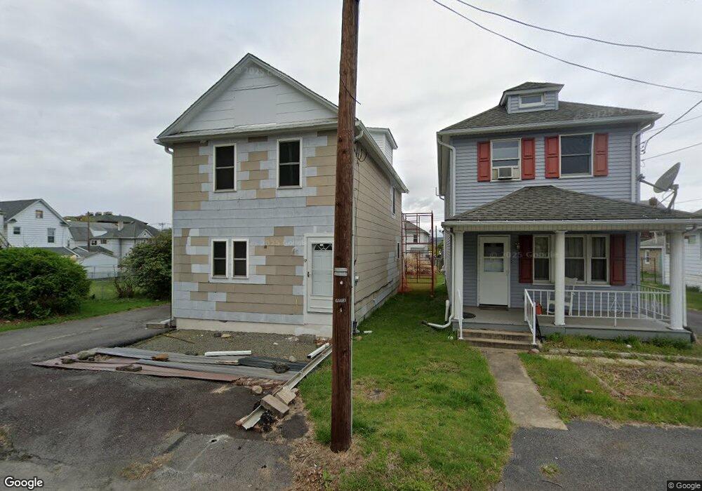
17 Dingwall St Wilkes Barre, PA 18705
Estimated Value: $136,000 - $172,000
3
Beds
1
Bath
1,422
Sq Ft
$106/Sq Ft
Est. Value
About This Home
This home is located at 17 Dingwall St, Wilkes Barre, PA 18705 and is currently estimated at $150,239, approximately $105 per square foot. 17 Dingwall St is a home located in Luzerne County with nearby schools including Leo E. Solomon-Plains Elementary School, Cradock Middle School, and Solomon/Plains Junior High School.
Ownership History
Date
Name
Owned For
Owner Type
Purchase Details
Closed on
Jun 12, 2013
Sold by
Wells Fargo Bank Na
Bought by
Gionvanini Michael B
Current Estimated Value
Home Financials for this Owner
Home Financials are based on the most recent Mortgage that was taken out on this home.
Original Mortgage
$20,000
Interest Rate
3.39%
Mortgage Type
Purchase Money Mortgage
Purchase Details
Closed on
Jul 10, 2012
Sold by
Rocker Gerald B and Rocker Gerald Bernard
Bought by
Wells Fargo Bank Na
Create a Home Valuation Report for This Property
The Home Valuation Report is an in-depth analysis detailing your home's value as well as a comparison with similar homes in the area
Home Values in the Area
Average Home Value in this Area
Purchase History
| Date | Buyer | Sale Price | Title Company |
|---|---|---|---|
| Gionvanini Michael B | $22,799 | None Available | |
| Wells Fargo Bank Na | $1,315 | None Available |
Source: Public Records
Mortgage History
| Date | Status | Borrower | Loan Amount |
|---|---|---|---|
| Closed | Gionvanini Michael B | $20,000 |
Source: Public Records
Tax History Compared to Growth
Tax History
| Year | Tax Paid | Tax Assessment Tax Assessment Total Assessment is a certain percentage of the fair market value that is determined by local assessors to be the total taxable value of land and additions on the property. | Land | Improvement |
|---|---|---|---|---|
| 2025 | $1,282 | $47,900 | $19,300 | $28,600 |
| 2024 | $1,282 | $47,900 | $19,300 | $28,600 |
| 2023 | $1,282 | $47,900 | $19,300 | $28,600 |
| 2022 | $1,273 | $47,900 | $19,300 | $28,600 |
| 2021 | $1,273 | $47,900 | $19,300 | $28,600 |
| 2020 | $1,273 | $47,900 | $19,300 | $28,600 |
| 2019 | $1,235 | $47,900 | $19,300 | $28,600 |
| 2018 | $1,207 | $47,900 | $19,300 | $28,600 |
| 2017 | $1,178 | $47,900 | $19,300 | $28,600 |
| 2016 | -- | $47,900 | $19,300 | $28,600 |
| 2015 | $1,250 | $47,900 | $19,300 | $28,600 |
| 2014 | $1,250 | $47,900 | $19,300 | $28,600 |
Source: Public Records
Map
Nearby Homes
- 9 Mack St
- 15 Price St
- 12 E Carey St
- 54 Mercer St
- 19 Cottage Ave
- 1326 N Washington St Unit PORTFOLIO 3 BUILDING
- 44 E Thomas St
- 220 Saint Clair St
- 185 N Main St
- 102 E Main Rear St
- 20 Crow St
- 55 Merlino Dr
- 18 Samantha Dr
- 12 Mayock St
- 11 Mayock St
- 9 Mayock St
- 13 Mayock St
- 10 Mayock St
- 452 River St
- 98 Stark St