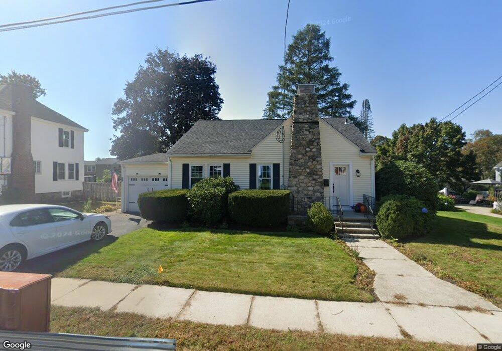
17 Edmands Rd North Andover, MA 01845
Estimated Value: $612,000 - $731,000
2
Beds
1
Bath
1,854
Sq Ft
$364/Sq Ft
Est. Value
About This Home
This home is located at 17 Edmands Rd, North Andover, MA 01845 and is currently estimated at $675,542, approximately $364 per square foot. 17 Edmands Rd is a home located in Essex County with nearby schools including Thomson Elementary School, North Andover Middle School, and North Andover High School.
Ownership History
Date
Name
Owned For
Owner Type
Purchase Details
Closed on
Jul 2, 2013
Sold by
Cashman Thomas P and Lascola Sherrie A
Bought by
Lascola Sherrie A
Current Estimated Value
Home Financials for this Owner
Home Financials are based on the most recent Mortgage that was taken out on this home.
Original Mortgage
$196,000
Outstanding Balance
$140,019
Interest Rate
3.51%
Mortgage Type
New Conventional
Estimated Equity
$535,523
Purchase Details
Closed on
Jan 25, 1999
Sold by
Dyer Ellen M
Bought by
Cashman Thomas P and Lascola Sherrie A
Home Financials for this Owner
Home Financials are based on the most recent Mortgage that was taken out on this home.
Original Mortgage
$186,200
Interest Rate
6.7%
Mortgage Type
Purchase Money Mortgage
Create a Home Valuation Report for This Property
The Home Valuation Report is an in-depth analysis detailing your home's value as well as a comparison with similar homes in the area
Home Values in the Area
Average Home Value in this Area
Purchase History
| Date | Buyer | Sale Price | Title Company |
|---|---|---|---|
| Lascola Sherrie A | -- | -- | |
| Cashman Thomas P | $196,000 | -- |
Source: Public Records
Mortgage History
| Date | Status | Borrower | Loan Amount |
|---|---|---|---|
| Open | Lascola Sherrie A | $196,000 | |
| Previous Owner | Cashman Thomas P | $186,200 |
Source: Public Records
Tax History Compared to Growth
Tax History
| Year | Tax Paid | Tax Assessment Tax Assessment Total Assessment is a certain percentage of the fair market value that is determined by local assessors to be the total taxable value of land and additions on the property. | Land | Improvement |
|---|---|---|---|---|
| 2025 | $6,080 | $540,000 | $299,200 | $240,800 |
| 2024 | $5,882 | $530,400 | $281,600 | $248,800 |
| 2023 | $5,779 | $472,100 | $258,700 | $213,400 |
| 2022 | $5,714 | $422,300 | $232,300 | $190,000 |
| 2021 | $5,685 | $401,200 | $211,200 | $190,000 |
| 2020 | $5,403 | $393,200 | $211,200 | $182,000 |
| 2019 | $5,273 | $393,200 | $211,200 | $182,000 |
| 2018 | $5,713 | $393,200 | $211,200 | $182,000 |
| 2017 | $4,875 | $341,400 | $174,300 | $167,100 |
| 2016 | $4,803 | $336,600 | $171,000 | $165,600 |
| 2015 | $4,611 | $320,400 | $165,200 | $155,200 |
Source: Public Records
Map
Nearby Homes
- 8 Little Rd
- 11 Putnam Rd
- 33 Pilgrim St
- 59 Maple Ave Unit 59
- 183 Massachusetts Ave
- 177-179 Massachusetts Ave
- 11 Fernwood St
- 114 Beverly St
- 350 Greene St Unit 105
- 88 Elm St Unit 1
- 24 Faulkner Rd
- 416 Waverley Rd
- 24 Marblehead St
- 148-150 Water St
- 148 Main St Unit S327
- 148 Main St Unit O102
- 148 Main St Unit A510
- 58 May St
- 53 May St
- 92 Martin Ave