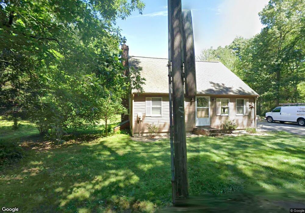
17 Harvey St Norton, MA 02766
Estimated Value: $572,048 - $588,000
3
Beds
3
Baths
1,260
Sq Ft
$460/Sq Ft
Est. Value
About This Home
This home is located at 17 Harvey St, Norton, MA 02766 and is currently estimated at $579,262, approximately $459 per square foot. 17 Harvey St is a home located in Bristol County with nearby schools including J.C. Solmonese Elementary School, Henri A. Yelle Elementary School, and Norton Middle School.
Ownership History
Date
Name
Owned For
Owner Type
Purchase Details
Closed on
May 31, 2007
Sold by
Perry Ronald G
Bought by
Kovich-Perry Deborah and Perry Ronald G
Current Estimated Value
Purchase Details
Closed on
Mar 8, 1993
Sold by
Rubin Inna T and Ohearn Ellen
Bought by
Perry Ronald G
Create a Home Valuation Report for This Property
The Home Valuation Report is an in-depth analysis detailing your home's value as well as a comparison with similar homes in the area
Home Values in the Area
Average Home Value in this Area
Purchase History
| Date | Buyer | Sale Price | Title Company |
|---|---|---|---|
| Kovich-Perry Deborah | -- | -- | |
| Perry Ronald G | $60,000 | -- |
Source: Public Records
Mortgage History
| Date | Status | Borrower | Loan Amount |
|---|---|---|---|
| Previous Owner | Perry Ronald G | $28,000 | |
| Previous Owner | Perry Ronald G | $20,000 |
Source: Public Records
Tax History Compared to Growth
Tax History
| Year | Tax Paid | Tax Assessment Tax Assessment Total Assessment is a certain percentage of the fair market value that is determined by local assessors to be the total taxable value of land and additions on the property. | Land | Improvement |
|---|---|---|---|---|
| 2025 | $57 | $440,500 | $185,000 | $255,500 |
| 2024 | $5,475 | $422,800 | $176,100 | $246,700 |
| 2023 | $5,186 | $399,200 | $166,100 | $233,100 |
| 2022 | $5,032 | $352,900 | $151,000 | $201,900 |
| 2021 | $4,815 | $322,500 | $143,900 | $178,600 |
| 2020 | $4,635 | $313,200 | $139,600 | $173,600 |
| 2019 | $4,492 | $301,500 | $134,300 | $167,200 |
| 2018 | $4,325 | $285,300 | $134,300 | $151,000 |
| 2017 | $4,216 | $274,300 | $134,300 | $140,000 |
| 2016 | $4,116 | $263,700 | $134,300 | $129,400 |
| 2015 | $3,995 | $259,600 | $131,700 | $127,900 |
| 2014 | $3,829 | $249,100 | $125,400 | $123,700 |
Source: Public Records
Map
Nearby Homes
- 48 Dean St
- 225 S Worcester St Unit 1
- 225 S Worcester St Unit 2
- 127 John Scott Blvd
- 125 John Scott Blvd
- 182 John Scott Blvd
- 178 S Worcester St
- 170 S Worcester St Unit 3
- 145 S Worcester St
- 4 Colonial Dr Unit 4
- 38 Danielle St
- 108 S Worcester St
- 75 Barrows St
- 55 Sturdy St
- 53 Sturdy St
- 8 Kasmira Way
- 3 Gilberts Way
- 16 Park Ln
- 30 Michael Rd
- 64 Ridgehill Rd