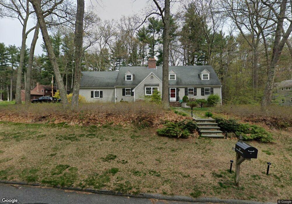
17 High Pine Cir Concord, MA 01742
Estimated Value: $1,341,000 - $1,406,000
5
Beds
4
Baths
2,558
Sq Ft
$535/Sq Ft
Est. Value
About This Home
This home is located at 17 High Pine Cir, Concord, MA 01742 and is currently estimated at $1,368,353, approximately $534 per square foot. 17 High Pine Cir is a home located in Middlesex County with nearby schools including Thoreau Elementary School, Concord Middle School, and Concord Carlisle High School.
Ownership History
Date
Name
Owned For
Owner Type
Purchase Details
Closed on
Dec 5, 2002
Sold by
Maher Francis B and Maher Mary Ellen
Bought by
Giangregorio Ellen O and Giangregorio John
Current Estimated Value
Home Financials for this Owner
Home Financials are based on the most recent Mortgage that was taken out on this home.
Original Mortgage
$300,000
Outstanding Balance
$129,790
Interest Rate
6.34%
Mortgage Type
Purchase Money Mortgage
Estimated Equity
$1,238,563
Create a Home Valuation Report for This Property
The Home Valuation Report is an in-depth analysis detailing your home's value as well as a comparison with similar homes in the area
Home Values in the Area
Average Home Value in this Area
Purchase History
| Date | Buyer | Sale Price | Title Company |
|---|---|---|---|
| Giangregorio Ellen O | $630,000 | -- |
Source: Public Records
Mortgage History
| Date | Status | Borrower | Loan Amount |
|---|---|---|---|
| Open | Giangregorio Ellen O | $300,000 |
Source: Public Records
Tax History
| Year | Tax Paid | Tax Assessment Tax Assessment Total Assessment is a certain percentage of the fair market value that is determined by local assessors to be the total taxable value of land and additions on the property. | Land | Improvement |
|---|---|---|---|---|
| 2025 | $155 | $1,169,000 | $417,600 | $751,400 |
| 2024 | $15,349 | $1,169,000 | $417,600 | $751,400 |
| 2023 | $12,440 | $959,900 | $348,000 | $611,900 |
| 2022 | $12,277 | $831,800 | $308,700 | $523,100 |
| 2021 | $12,312 | $836,400 | $308,700 | $527,700 |
| 2020 | $11,693 | $821,700 | $308,700 | $513,000 |
| 2019 | $11,857 | $835,600 | $329,100 | $506,500 |
| 2018 | $11,271 | $788,700 | $327,400 | $461,300 |
| 2017 | $10,627 | $755,300 | $294,000 | $461,300 |
| 2016 | $10,426 | $749,000 | $294,000 | $455,000 |
| 2015 | $9,817 | $687,000 | $272,200 | $414,800 |
Source: Public Records
Map
Nearby Homes
- 96 Forest Ridge Rd Unit 96
- 1201 Old Marlboro Rd
- 100 Harrington Ave
- 1844 Main St Unit 1844
- 27 Water St
- 37 Water St
- 20 Westvale Meadows Unit C
- 2 Skyview Ln
- 26 Field Rd
- 23 Deer Path Unit 5
- 66 Old Stow Rd
- 1 Drummer Rd Unit A5
- 31 Drummer Rd Unit 31
- 42 Dakin Rd
- 53 Prairie St
- 22 Center Village Dr
- 57 Longfellow Rd
- 70 McCallar Ln
- 65 Summit St
- 132 Williams Rd
- 33 High Pine Cir
- 121 Border Rd
- 144 Border Rd
- 134 Border Rd
- 45 High Pine Cir
- 118 Border Rd
- 188 Border Rd
- 55 High Pine Cir
- 104 Border Rd
- 65 High Pine Cir
- 92 Border Rd
- 210 Border Rd
- 611 Hayward Mill Rd
- 595 Hayward Mill Rd
- 69 Border Rd
- 581 Hayward Mill Rd
- 77 High Pine Cir
- 78 Border Rd
- 76 High Pine Cir
- 571 Hayward Mill Rd
Your Personal Tour Guide
Ask me questions while you tour the home.