
Seller's Agent in 2025
David Turton
Diane Turton, Realtors-Point Pleasant Boro
(732) 600-8228
1 in this area
133 Total Sales

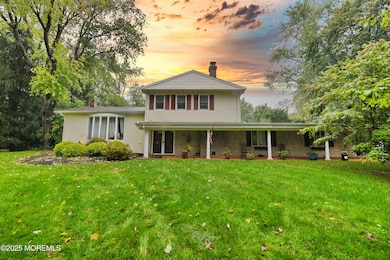
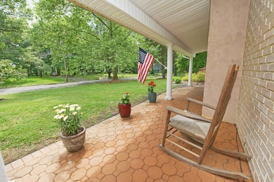
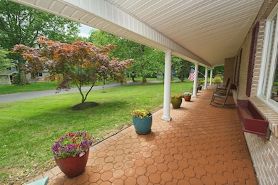
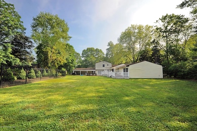
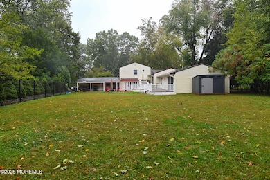
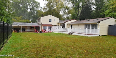
Located in desirable Lincroft, this impressive 4,200 sq ft custom home sits on over 3⁄4 of an acre! Designed for entertaining, the home features a spacious gourmet kitchen w SS appliances, granite counters, a breakfast bar & an elegant dining rm w a large picture window & hardwood flrs. The primary suite is currently being used as a great rm, complete w/ a FP, skylights, 2 walk-in closets & a luxurious marble bath w whirlpool tub, double sinks & a steam shower. Welcoming family rm w fireplace, wet bar, full bath & guest bedroom offers great flexibility for guests or a possible mother/daughter setup. Enjoy outdoor living w 3 sets of sliders leading to Trex decks & a brick patio overlooking the private yard. Ideally located just minutes from top-rated schools, shopping, NYC transportation, Lincroft Town Village, downtown Red Bank & the Jersey Shore beaches!
Last Agent to Sell the Property
Diane Turton, Realtors-Point Pleasant Boro License #9485963 Listed on: 10/16/2025
| Date | Type | Sale Price | Title Company |
|---|---|---|---|
| Deed | $920,000 | Triton Title & Abstract | |
| Deed | $530,000 | Fidelity National Title Ins | |
| Deed | $250,000 | -- |
| Date | Status | Loan Amount | Loan Type |
|---|---|---|---|
| Open | $260,000 | New Conventional | |
| Previous Owner | $424,000 | New Conventional | |
| Previous Owner | $188,000 | No Value Available |
| Date | Event | Price | List to Sale | Price per Sq Ft |
|---|---|---|---|---|
| 12/19/2025 12/19/25 | Sold | $920,000 | -8.0% | $262 / Sq Ft |
| 11/12/2025 11/12/25 | Pending | -- | -- | -- |
| 10/16/2025 10/16/25 | For Sale | $1,000,000 | -- | $285 / Sq Ft |
| Year | Tax Paid | Tax Assessment Tax Assessment Total Assessment is a certain percentage of the fair market value that is determined by local assessors to be the total taxable value of land and additions on the property. | Land | Improvement |
|---|---|---|---|---|
| 2025 | $14,910 | $972,600 | $484,100 | $488,500 |
| 2024 | $12,204 | $906,400 | $413,000 | $493,400 |
| 2023 | $12,204 | $702,200 | $285,000 | $417,200 |
| 2022 | $12,636 | $667,500 | $270,300 | $397,200 |
| 2021 | $12,636 | $607,500 | $254,200 | $353,300 |
| 2020 | $12,817 | $599,500 | $254,200 | $345,300 |
| 2019 | $14,885 | $704,800 | $254,200 | $450,600 |
| 2018 | $12,551 | $579,200 | $254,200 | $325,000 |
| 2017 | $12,280 | $561,000 | $243,000 | $318,000 |
| 2016 | $11,635 | $546,000 | $243,000 | $303,000 |
| 2015 | $12,139 | $550,000 | $243,000 | $307,000 |
| 2014 | $11,994 | $530,000 | $243,000 | $287,000 |
Seller's Agent in 2025
David Turton
Diane Turton, Realtors-Point Pleasant Boro
(732) 600-8228
1 in this area
133 Total Sales
Buyer's Agent in 2025
Debra Annunziata
Keller Williams Realty West Monmouth
(718) 757-9979
1 in this area
43 Total Sales
Source: MOREMLS (Monmouth Ocean Regional REALTORS®)
MLS Number: 22531311
APN: 32-01110-0000-00011
Disclaimer: Certain information contained herein is derived from information provided by parties other than Homes.com. All information provided is deemed reliable, but is not guaranteed to be accurate and should be independently verified.
![]() IDX information is provided exclusively for personal, non-commercial use, and may not be used for any purpose other than to identify prospective properties consumers may be interested in purchasing.
IDX information is provided exclusively for personal, non-commercial use, and may not be used for any purpose other than to identify prospective properties consumers may be interested in purchasing.
Information is deemed reliable but not guaranteed.
Ask me questions while you tour the home.