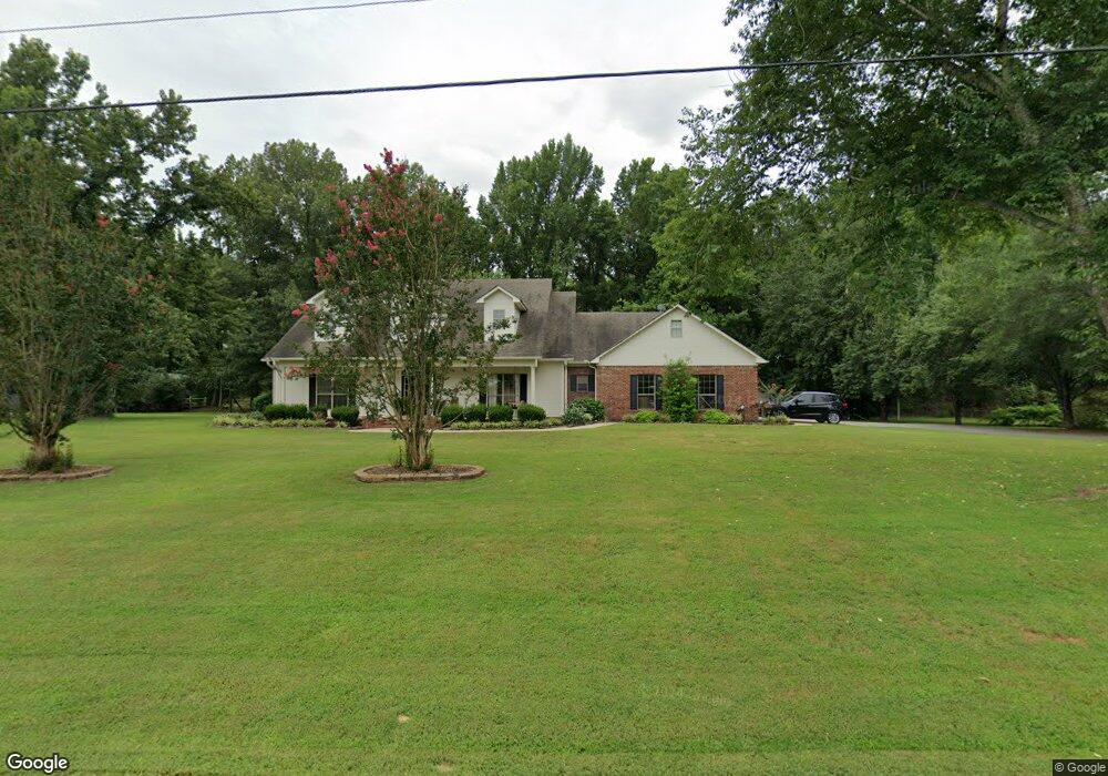
17 Kali Ct Conway, AR 72032
Estimated Value: $317,000 - $364,204
Studio
2
Baths
2,262
Sq Ft
$146/Sq Ft
Est. Value
About This Home
This home is located at 17 Kali Ct, Conway, AR 72032 and is currently estimated at $330,801, approximately $146 per square foot. 17 Kali Ct is a home located in Faulkner County with nearby schools including Vilonia Junior High School and Vilonia High School.
Ownership History
Date
Name
Owned For
Owner Type
Purchase Details
Closed on
Mar 1, 2017
Sold by
Cole Deborah Faye
Bought by
Gore Glenda D and Brewer Linda A
Current Estimated Value
Purchase Details
Closed on
Nov 2, 2007
Bought by
Gore
Home Financials for this Owner
Home Financials are based on the most recent Mortgage that was taken out on this home.
Original Mortgage
$192,800
Interest Rate
6.37%
Mortgage Type
New Conventional
Purchase Details
Closed on
Nov 1, 2007
Sold by
Tiner Bennie G and Tiner Cynthia L
Bought by
Gore Michael and Gore Glenda
Home Financials for this Owner
Home Financials are based on the most recent Mortgage that was taken out on this home.
Original Mortgage
$192,800
Interest Rate
6.37%
Mortgage Type
New Conventional
Purchase Details
Closed on
Jul 21, 1997
Bought by
Tiner
Purchase Details
Closed on
Sep 11, 1995
Bought by
Stroinski
Create a Home Valuation Report for This Property
The Home Valuation Report is an in-depth analysis detailing your home's value as well as a comparison with similar homes in the area
Home Values in the Area
Average Home Value in this Area
Purchase History
| Date | Buyer | Sale Price | Title Company |
|---|---|---|---|
| Gore Glenda D | $2,000 | None Available | |
| Gore | $193,000 | -- | |
| Gore Michael | $193,000 | None Available | |
| Gore | $193,000 | -- | |
| Tiner | $22,500 | -- | |
| Stroinski | -- | -- | |
| Stroinski | $15,000 | -- |
Source: Public Records
Mortgage History
| Date | Status | Borrower | Loan Amount |
|---|---|---|---|
| Previous Owner | Gore Michael | $192,800 |
Source: Public Records
Tax History
| Year | Tax Paid | Tax Assessment Tax Assessment Total Assessment is a certain percentage of the fair market value that is determined by local assessors to be the total taxable value of land and additions on the property. | Land | Improvement |
|---|---|---|---|---|
| 2025 | $2,330 | $64,570 | $5,000 | $59,570 |
| 2024 | $2,234 | $64,570 | $5,000 | $59,570 |
| 2023 | $2,127 | $44,130 | $5,000 | $39,130 |
| 2022 | $1,802 | $44,130 | $5,000 | $39,130 |
| 2021 | $1,711 | $44,130 | $5,000 | $39,130 |
| 2020 | $1,615 | $40,240 | $5,000 | $35,240 |
| 2019 | $1,605 | $40,240 | $5,000 | $35,240 |
| 2018 | $1,630 | $40,240 | $5,000 | $35,240 |
| 2017 | $1,630 | $41,250 | $5,000 | $36,250 |
| 2016 | $1,678 | $41,250 | $5,000 | $36,250 |
| 2015 | $1,920 | $39,830 | $5,000 | $34,830 |
| 2014 | $1,610 | $39,830 | $5,000 | $34,830 |
Source: Public Records
Map
Nearby Homes
- 738 Highway 64 B
- 66 Eaglebrook Dr
- 8 Bishop Ln
- 25 S Simon Ln
- 678 Main St
- Lot 19 Liberty Creek Rd
- 000 Hwy 64 E
- 111 Justice Farm Rd
- 25 Sun Drenched Trail
- 15 Appaloosa Trail
- 599 Beryl Rd S
- 9 Hickory Ridge Rd
- 16 Eagle Valley Rd
- 6 Brentwood Dr
- TBD Eagle Valley Rd
- 4 Spradlin Rd
- 0 Hwy 64 E Unit 25050006
- 26 Eagle Valley Rd
- 19 Country Meadows Dr
- 42 Rose Dr
Your Personal Tour Guide
Ask me questions while you tour the home.