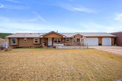
17 Longabaugh Rd Sundance, WY 82729
Estimated payment $3,783/month
Highlights
- Very Popular Property
- Multiple Fireplaces
- Main Floor Primary Bedroom
- Wood Burning Stove
- Wood Flooring
- No HOA
About This Home
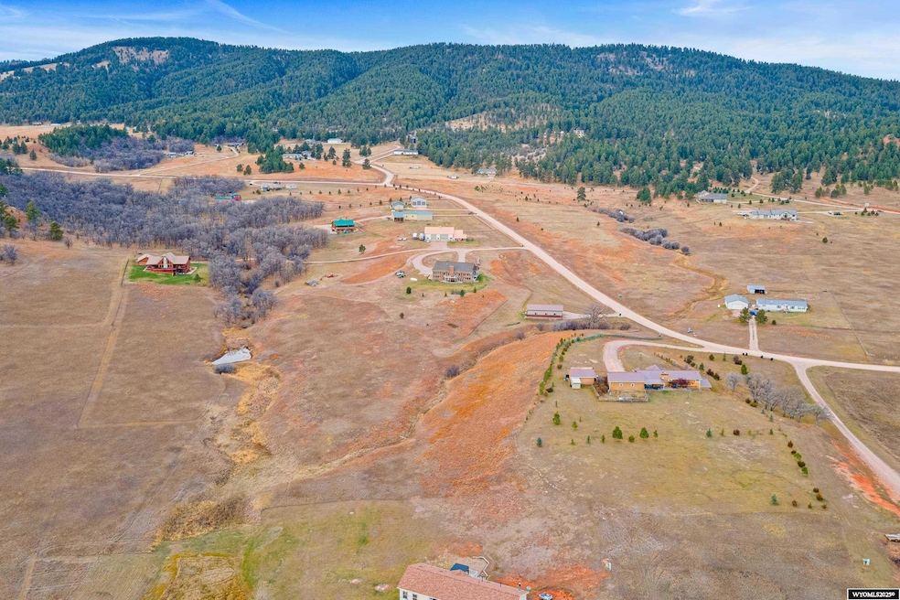
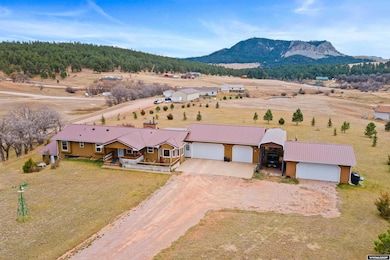
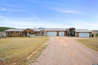
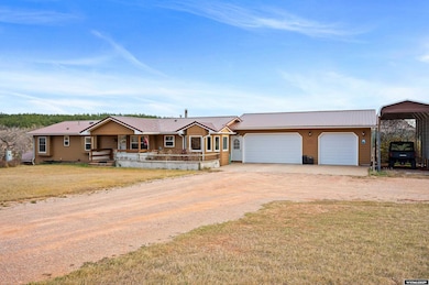
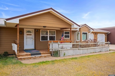
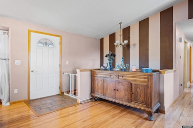
Stunning 4-Bedroom Home on 5 Acres with Sundance Mountain Views! Welcome home to this beautifully maintained 4 bed, 3.25 bath property in Sundance, Wyoming, offering over 3,000 sq ft of comfortable living space and breathtaking views of the Sundance Mountains. Step inside to a spacious island kitchen featuring solid surface countertops, a full-height tile backsplash, and ample cabinetry — perfect for gathering and entertaining. From the office, step out to the covered patios, ideal for enjoying quiet mornings or evening sunsets. The primary suite offers a private retreat complete with an ensuite bath, corner jetted soaking tub, and generous closet space. Enjoy main-level living with a cozy fireplace, while the lower level features a wood stove for added warmth and ambiance. Outside, you’ll find ample trees + 5 acres of lightly covenanted land — horses welcome! The property offers a thoughtful blend of convenience and versatility, beginning with a 3-car attached garage and a carport, plus an additional 2-car detached garage situated at the front of the home. Beyond that, extra storage spaces with roll-up garage doors provide even more room for bikes, tools, and anything else you need to tuck away! Built in 2006, this home combines modern comfort, mountain charm, and the freedom of wide-open Wyoming living. Key Features: • 4 Bedrooms | 3.25 Bathrooms | 3,000+ Sq Ft • Built in 2006 • 5-Car Attached Garage • 5 Acres with Light Covenants (Horses Allowed) • Solid Surface Countertops & Tile Backsplash • Two Fireplaces (Gas on Main & Wood Stove on Lower Level) • Covered Patios with Mountain Views Experience the perfect blend of comfort, space, and scenic beauty — all just minutes from the heart of Sundance.
Listing Agent
Berkshire Hathaway HomeServices Midwest Realty License #RE-15825 Listed on: 11/06/2025

Open House Schedule
-
Sunday, December 14, 20251:00 to 3:00 pm12/14/2025 1:00:00 PM +00:0012/14/2025 3:00:00 PM +00:00Add to Calendar
Property Details
Home Type
- Modular Prefabricated Home
Est. Annual Taxes
- $2,791
Year Built
- Built in 2006
Lot Details
- 5.01 Acre Lot
- Manual Sprinklers System
Parking
- 5 Car Attached Garage
Home Design
- Metal Roof
- Vinyl Construction Material
- Tile
Interior Spaces
- Multiple Fireplaces
- Wood Burning Stove
- Gas Fireplace
- Family Room
- Living Room
- Dining Room
- Den
- Basement Fills Entire Space Under The House
- Laundry on main level
Kitchen
- Oven or Range
- Dishwasher
Flooring
- Wood
- Wall to Wall Carpet
- Laminate
- Tile
Bedrooms and Bathrooms
- 4 Bedrooms
- Primary Bedroom on Main
- 3.5 Bathrooms
Outdoor Features
- Covered Patio or Porch
Utilities
- Central Air
- Heating Available
- Septic System
Community Details
- No Home Owners Association
Map
Home Values in the Area
Average Home Value in this Area
Tax History
| Year | Tax Paid | Tax Assessment Tax Assessment Total Assessment is a certain percentage of the fair market value that is determined by local assessors to be the total taxable value of land and additions on the property. | Land | Improvement |
|---|---|---|---|---|
| 2025 | $2,689 | $48,059 | $5,177 | $42,882 |
| 2024 | $2,689 | $44,652 | $6,902 | $37,750 |
| 2023 | $2,753 | $43,017 | $6,684 | $36,333 |
| 2022 | $2,753 | $44,051 | $4,974 | $39,077 |
| 2021 | $2,728 | $43,649 | $4,344 | $39,305 |
| 2020 | $2,235 | $35,764 | $4,618 | $31,146 |
| 2019 | -- | $35,006 | $4,542 | $30,464 |
| 2018 | $0 | $30,170 | $4,805 | $25,365 |
| 2017 | $0 | $37,796 | $960 | $36,836 |
| 2016 | -- | $33,249 | $1,149 | $32,100 |
| 2015 | -- | $31,161 | $4,650 | $26,511 |
| 2014 | -- | $37,524 | $4,650 | $32,874 |
Property History
| Date | Event | Price | List to Sale | Price per Sq Ft |
|---|---|---|---|---|
| 12/08/2025 12/08/25 | Price Changed | $675,000 | -3.6% | $184 / Sq Ft |
| 12/03/2025 12/03/25 | Price Changed | $700,000 | -2.1% | $190 / Sq Ft |
| 12/02/2025 12/02/25 | Price Changed | $715,000 | -1.4% | $194 / Sq Ft |
| 11/06/2025 11/06/25 | For Sale | $725,000 | -- | $197 / Sq Ft |
Purchase History
| Date | Type | Sale Price | Title Company |
|---|---|---|---|
| Warranty Deed | -- | None Listed On Document | |
| Warranty Deed | -- | None Available |
Mortgage History
| Date | Status | Loan Amount | Loan Type |
|---|---|---|---|
| Open | $464,000 | New Conventional |
Source: Wyoming MLS
MLS Number: 20255928
APN: 5163-11-3-03-005.00
Disclaimer: Certain information contained herein is derived from information provided by parties other than Homes.com. All information provided is deemed reliable, but is not guaranteed to be accurate and should be independently verified.
![]() Information deemed reliable but not guaranteed. All properties are subject to prior sale, change or withdrawal. The data relating to real estate on this web site comes in part from the Wyoming MLS Internet Data Exchange Program. Real estate listings held by brokerage firms other than the listing office named are marked with the Wyoming MLS IDX logo and detailed information about them includes the name of the listing broker. The information being provided is for consumers’ personal, non-commercial use and may not be used for any purpose other than to identify prospective properties consumers may be interested in purchasing.
Information deemed reliable but not guaranteed. All properties are subject to prior sale, change or withdrawal. The data relating to real estate on this web site comes in part from the Wyoming MLS Internet Data Exchange Program. Real estate listings held by brokerage firms other than the listing office named are marked with the Wyoming MLS IDX logo and detailed information about them includes the name of the listing broker. The information being provided is for consumers’ personal, non-commercial use and may not be used for any purpose other than to identify prospective properties consumers may be interested in purchasing.
- Tbd Sugarloaf Ct
- 315 E Sewell St
- 119 W Thompson St
- 412 1/2 E Sewell St
- 305 S 5th St
- 138 Commercial Ln
- 0000 Commercial Ln
- 922 S West St
- 145 Vista Cir
- 330 U S 14
- Tbd Sugar Loaf Ct
- L1 High Mile Rd
- L3 High Mile Rd
- 1117 Patriot Place
- 1114 Patriot Place
- TBD E Cleveland St
- TBD S 11th St
- TBD Reynolds Rd
- 1115 Bowers Rd
- Tract 5 Old Sundance Rd