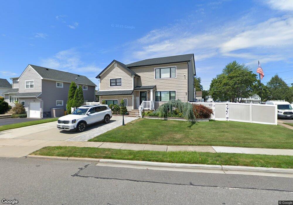
17 N Pine St Massapequa, NY 11758
Estimated Value: $738,000 - $903,916
4
Beds
3
Baths
1,941
Sq Ft
$423/Sq Ft
Est. Value
About This Home
This home is located at 17 N Pine St, Massapequa, NY 11758 and is currently estimated at $820,958, approximately $422 per square foot. 17 N Pine St is a home located in Nassau County with nearby schools including Charles E. Schwarting School, Plainedge Middle School, and Plainedge Senior High School.
Ownership History
Date
Name
Owned For
Owner Type
Purchase Details
Closed on
Jun 9, 2017
Sold by
Franconia Real Estate Services Inc
Bought by
Cuevas Braulio and Cuevas Margarita Dejesus
Current Estimated Value
Home Financials for this Owner
Home Financials are based on the most recent Mortgage that was taken out on this home.
Original Mortgage
$378,000
Outstanding Balance
$314,675
Interest Rate
4.05%
Mortgage Type
New Conventional
Estimated Equity
$506,283
Purchase Details
Closed on
Sep 28, 2016
Sold by
Sullivan Eric and Sullivan Tara
Bought by
Franconia Real Estate Services Inc
Purchase Details
Closed on
Jul 25, 2006
Sold by
Bernstein Judith
Bought by
Sullivan Eric
Create a Home Valuation Report for This Property
The Home Valuation Report is an in-depth analysis detailing your home's value as well as a comparison with similar homes in the area
Home Values in the Area
Average Home Value in this Area
Purchase History
| Date | Buyer | Sale Price | Title Company |
|---|---|---|---|
| Cuevas Braulio | $445,000 | None Available | |
| Franconia Real Estate Services Inc | $481,000 | None Available | |
| Sullivan Eric | $485,000 | -- |
Source: Public Records
Mortgage History
| Date | Status | Borrower | Loan Amount |
|---|---|---|---|
| Open | Cuevas Braulio | $378,000 |
Source: Public Records
Tax History Compared to Growth
Tax History
| Year | Tax Paid | Tax Assessment Tax Assessment Total Assessment is a certain percentage of the fair market value that is determined by local assessors to be the total taxable value of land and additions on the property. | Land | Improvement |
|---|---|---|---|---|
| 2025 | $3,745 | $615 | $237 | $378 |
| 2024 | $3,684 | $633 | $249 | $384 |
| 2023 | $3,185 | $598 | $230 | $368 |
| 2022 | $3,185 | $646 | $249 | $397 |
| 2021 | $3,254 | $619 | $239 | $380 |
| 2020 | $5,135 | $700 | $444 | $256 |
| 2019 | $2,518 | $901 | $503 | $398 |
| 2018 | $3,028 | $901 | $0 | $0 |
| 2017 | $11,721 | $1,023 | $571 | $452 |
| 2016 | $17,117 | $1,023 | $571 | $452 |
| 2015 | $4,663 | $1,023 | $571 | $452 |
| 2014 | $4,663 | $1,023 | $571 | $452 |
| 2013 | $4,328 | $1,023 | $571 | $452 |
Source: Public Records
Map
Nearby Homes
- 3 Rutland Rd
- 4090 Sherrey Ct
- 344 N Hickory St
- 240 Wyngate Dr
- 408 Briarwood Rd
- 7 Crocus Dr
- 5 Webster Ave
- 530 N Oak St
- 558 N Hawthorne St
- 530 N Hawthorne St
- 282 N Oak St
- 267 N Elm St
- 208 Daniel Rd N
- 956 N Park Ave
- 7 Norman Place
- 68 Thorne Ave
- 267 N Poplar St
- 4129 Duff Place
- 598 N Suffolk Ave
- 27 Midlawn Dr