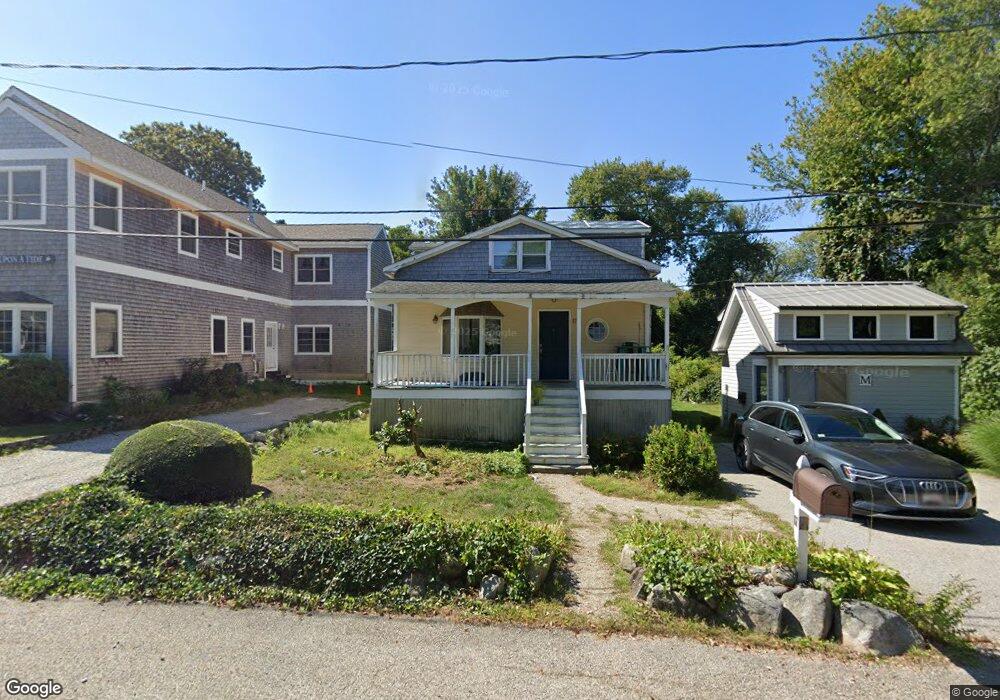
17 Nelson Rd Scituate, MA 02066
Estimated Value: $624,499 - $761,000
3
Beds
2
Baths
1,350
Sq Ft
$523/Sq Ft
Est. Value
About This Home
This home is located at 17 Nelson Rd, Scituate, MA 02066 and is currently estimated at $706,625, approximately $523 per square foot. 17 Nelson Rd is a home located in Plymouth County with nearby schools including Wampatuck Elementary School, Lester J. Gates Middle School, and Scituate High School.
Ownership History
Date
Name
Owned For
Owner Type
Purchase Details
Closed on
Mar 14, 2008
Sold by
Linder Christopher A and Delaney Meghan
Bought by
Marshall Steven and Marshall Heather
Current Estimated Value
Purchase Details
Closed on
Jun 7, 2004
Sold by
Canavan James F
Bought by
Linder Christopher A and Delaney Meghan
Purchase Details
Closed on
Aug 11, 1995
Sold by
Horne Mark and Horne Linda M
Bought by
Canavan John F and Canavan Nora L
Home Financials for this Owner
Home Financials are based on the most recent Mortgage that was taken out on this home.
Original Mortgage
$117,000
Interest Rate
7.48%
Mortgage Type
Purchase Money Mortgage
Purchase Details
Closed on
Jan 4, 1988
Sold by
Johnson Carl S
Bought by
Horne Mark M
Create a Home Valuation Report for This Property
The Home Valuation Report is an in-depth analysis detailing your home's value as well as a comparison with similar homes in the area
Home Values in the Area
Average Home Value in this Area
Purchase History
| Date | Buyer | Sale Price | Title Company |
|---|---|---|---|
| Marshall Steven | $331,000 | -- | |
| Linder Christopher A | $340,000 | -- | |
| Canavan John F | $130,000 | -- | |
| Horne Mark M | $130,000 | -- |
Source: Public Records
Mortgage History
| Date | Status | Borrower | Loan Amount |
|---|---|---|---|
| Open | Horne Mark M | $326,261 | |
| Previous Owner | Horne Mark M | $163,600 | |
| Previous Owner | Horne Mark M | $117,000 |
Source: Public Records
Tax History
| Year | Tax Paid | Tax Assessment Tax Assessment Total Assessment is a certain percentage of the fair market value that is determined by local assessors to be the total taxable value of land and additions on the property. | Land | Improvement |
|---|---|---|---|---|
| 2025 | $5,063 | $506,800 | $390,900 | $115,900 |
| 2024 | $4,915 | $474,400 | $355,300 | $119,100 |
| 2023 | $4,657 | $433,700 | $323,000 | $110,700 |
| 2022 | $4,657 | $369,000 | $267,500 | $101,500 |
| 2021 | $4,411 | $330,900 | $242,000 | $88,900 |
| 2020 | $4,331 | $320,800 | $232,700 | $88,100 |
| 2019 | $4,320 | $314,400 | $228,100 | $86,300 |
| 2018 | $4,560 | $326,900 | $244,700 | $82,200 |
| 2017 | $4,462 | $316,700 | $234,500 | $82,200 |
| 2016 | $4,190 | $296,300 | $214,100 | $82,200 |
| 2015 | $3,748 | $286,100 | $203,900 | $82,200 |
Source: Public Records
Map
Nearby Homes
- 54 Woodland Rd
- 59 Captain Peirce Rd
- 430 Hatherly Rd
- 430 Hatherly Rd Unit Exhibit “A”
- 430 Hatherly Rd Unit Exhibit “B”
- 92 Marion Rd
- 49 Jackson Rd
- 33 Oceanside Dr
- 23 Oceanside Dr
- 74 Branch St Unit 15
- 86 Hatherly Rd
- 20 Lawson Rd
- 49 Whittier Dr
- 20 Lee Ave
- 38 Lauren Ln
- 1 Washington Ln
- 32 Barker Rd Unit 3
- 18A Mitchell Ave
- 11 Brookline Rd
- 629 Country Way
Your Personal Tour Guide
Ask me questions while you tour the home.