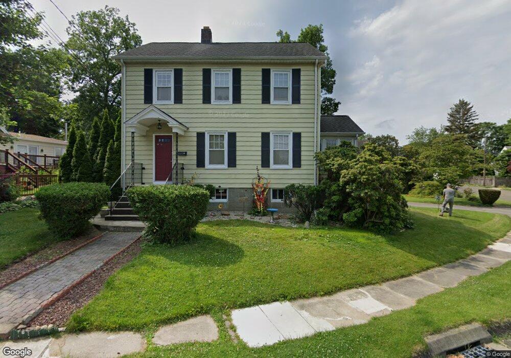
17 Pershing St Norwalk, CT 06851
Wolfpit NeighborhoodEstimated Value: $626,000 - $713,000
3
Beds
2
Baths
1,584
Sq Ft
$417/Sq Ft
Est. Value
About This Home
This home is located at 17 Pershing St, Norwalk, CT 06851 and is currently estimated at $659,957, approximately $416 per square foot. 17 Pershing St is a home located in Fairfield County with nearby schools including Tracey School, West Rocks Middle School, and Norwalk High School.
Ownership History
Date
Name
Owned For
Owner Type
Purchase Details
Closed on
Apr 2, 2007
Sold by
Langner Jacqueline and Palinkas Diane V
Bought by
W English Prop Llc
Current Estimated Value
Purchase Details
Closed on
Oct 9, 1998
Sold by
Yee Anthony and Yee Jasmine
Bought by
Langer Stuart M and Langer Georgia I
Home Financials for this Owner
Home Financials are based on the most recent Mortgage that was taken out on this home.
Original Mortgage
$215,200
Interest Rate
6.92%
Create a Home Valuation Report for This Property
The Home Valuation Report is an in-depth analysis detailing your home's value as well as a comparison with similar homes in the area
Home Values in the Area
Average Home Value in this Area
Purchase History
| Date | Buyer | Sale Price | Title Company |
|---|---|---|---|
| W English Prop Llc | $420,000 | -- | |
| W English Prop Llc | $420,000 | -- | |
| Langer Stuart M | $269,000 | -- | |
| Langer Stuart M | $269,000 | -- |
Source: Public Records
Mortgage History
| Date | Status | Borrower | Loan Amount |
|---|---|---|---|
| Previous Owner | Langer Stuart M | $187,000 | |
| Previous Owner | Langer Stuart M | $215,200 |
Source: Public Records
Tax History
| Year | Tax Paid | Tax Assessment Tax Assessment Total Assessment is a certain percentage of the fair market value that is determined by local assessors to be the total taxable value of land and additions on the property. | Land | Improvement |
|---|---|---|---|---|
| 2025 | $8,922 | $372,580 | $184,350 | $188,230 |
| 2024 | $8,790 | $372,580 | $184,350 | $188,230 |
| 2023 | $6,838 | $271,760 | $149,490 | $122,270 |
| 2022 | $6,710 | $271,760 | $149,490 | $122,270 |
| 2021 | $6,536 | $271,760 | $149,490 | $122,270 |
| 2020 | $3,669 | $271,760 | $149,490 | $122,270 |
| 2019 | $6,349 | $271,760 | $149,490 | $122,270 |
| 2018 | $7,330 | $274,910 | $170,050 | $104,860 |
| 2017 | $7,078 | $274,910 | $170,050 | $104,860 |
| 2016 | $7,010 | $274,910 | $170,050 | $104,860 |
| 2015 | $6,991 | $274,910 | $170,050 | $104,860 |
| 2014 | $6,900 | $274,910 | $170,050 | $104,860 |
Source: Public Records
Map
Nearby Homes
- 75 Newtown Ave
- 71 Saddle Rd
- 11 Margaret St
- 60 Wolfpit Ave Unit 4B
- 6 Clara Dr
- 4 Union Ave Unit 24
- 37 Murray St
- 12 Willard Rd Unit 8
- 46 Sunrise Hill Rd
- 80 County St Unit 9K
- 80 County St Unit 11K
- 34 Sunrise Hill Rd
- 142 Wolfpit Ave
- 19 Isaacs St Unit 405
- 178 Sunrise Hill Rd
- 16 Sunset Hill Ave
- 206 Sunrise Hill Rd Unit 206
- 226 Sunrise Hill Rd Unit 226
- 9 Trailside Dr
- 23 Macintosh Rd
- 15 Pershing St
- 7 Roosevelt St
- 11 Roosevelt St
- 24 Pershing St
- 20 Pershing St
- 13 Roosevelt St
- 26 Pershing St
- 11 Pershing St
- 18 Pershing St
- 16 Pershing St
- 3 Roosevelt St
- 15 Roosevelt St
- 1 Roosevelt St
- 17 Roosevelt St
- 7 Pershing St
- 12 Pershing St
- 8 1/2 Newtown Terrace
- 8 Newtown Terrace
- 54 Newtown Ave
- 19 Roosevelt St
Your Personal Tour Guide
Ask me questions while you tour the home.