
B
Seller's Agent in 2025
Brian Fox
Hanley Garrette Group LLC
(781) 820-2099
1 in this area
1 Total Sale
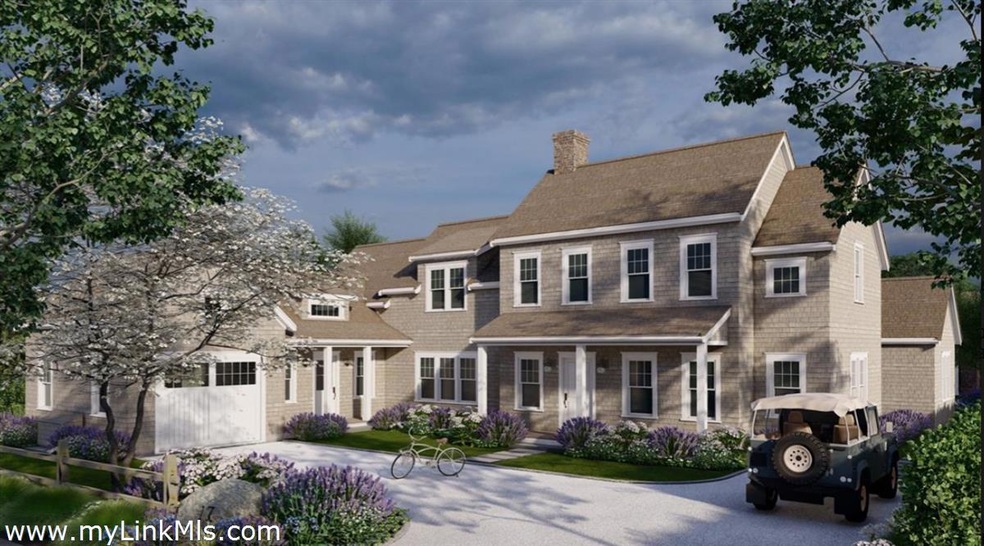


*Recorded sale is for land only, accompanied by separate $7m construction contract. Welcome to Cliff living at its finest! 17 Pilgrim is a rare opportunity to own a brand new home on a fabulous oversized property within walking distance to Town, north shore beaches and the Westmoor Club. Hanley Development has partnered with Sophie Metz Design to create a magnificent 7,600+ square foot compound featuring a 6 BR main house with garage, 2 BR guest house and pool/spa. The spacious main house has over 5,800 sq ft of finished living space with an attached garage and fully finished basement. The 2-story guest house offers an additional 1,826 sq ft of finished area with downstairs living space including full kitchen and two bedrooms upstairs. All bedrooms in both main and guest house are en-suite! The outdoor living is highlighted by the 16x30 pool with raised spa, outdoor kitchen and dining and a covered patio with fireplace off of the guest house. Construction is underway with completion scheduled for fall of 2026. Buyers now would have the ability to customize finishes or sit back and await full turnkey delivery of their dream home on the Cliff!
| Date | Type | Sale Price | Title Company |
|---|---|---|---|
| Quit Claim Deed | $5,175,000 | None Available | |
| Quit Claim Deed | $8,300,000 | None Available | |
| Deed | $360,000 | -- | |
| Deed | $360,000 | -- |
| Date | Status | Loan Amount | Loan Type |
|---|---|---|---|
| Previous Owner | $5,395,000 | Purchase Money Mortgage | |
| Previous Owner | $270,000 | No Value Available | |
| Previous Owner | $270,000 | Purchase Money Mortgage |
| Date | Event | Price | List to Sale | Price per Sq Ft |
|---|---|---|---|---|
| 09/23/2025 09/23/25 | Sold | $6,825,000 | -- | $892 / Sq Ft |
| Year | Tax Paid | Tax Assessment Tax Assessment Total Assessment is a certain percentage of the fair market value that is determined by local assessors to be the total taxable value of land and additions on the property. | Land | Improvement |
|---|---|---|---|---|
| 2025 | $5,369 | $1,636,900 | $1,636,900 | $0 |
| 2024 | $8,295 | $2,650,200 | $1,636,900 | $1,013,300 |
| 2023 | $7,075 | $2,203,900 | $1,563,700 | $640,200 |
| 2022 | $6,787 | $1,814,700 | $1,320,500 | $494,200 |
| 2021 | $6,130 | $1,688,600 | $1,216,300 | $472,300 |
| 2020 | $5,826 | $1,688,600 | $1,216,300 | $472,300 |
| 2019 | $5,512 | $1,640,400 | $1,168,100 | $472,300 |
| 2018 | $5,480 | $1,552,500 | $1,168,100 | $384,400 |
| 2017 | $5,337 | $1,574,400 | $1,168,100 | $406,300 |
| 2016 | $3,445 | $1,025,400 | $667,500 | $357,900 |
| 2015 | $3,384 | $937,400 | $579,500 | $357,900 |
| 2014 | $3,545 | $942,800 | $579,500 | $363,300 |
B
Seller's Agent in 2025
Brian Fox
Hanley Garrette Group LLC
(781) 820-2099
1 in this area
1 Total Sale
C
Buyer's Agent in 2025
Chandra Miller
Maury People Sotheby's International Realty
(508) 360-7777
143 in this area
143 Total Sales
Source: LINK
MLS Number: 92646
APN: NANT-000-041-000-000-0002-14-000-000
Ask me questions while you tour the home.