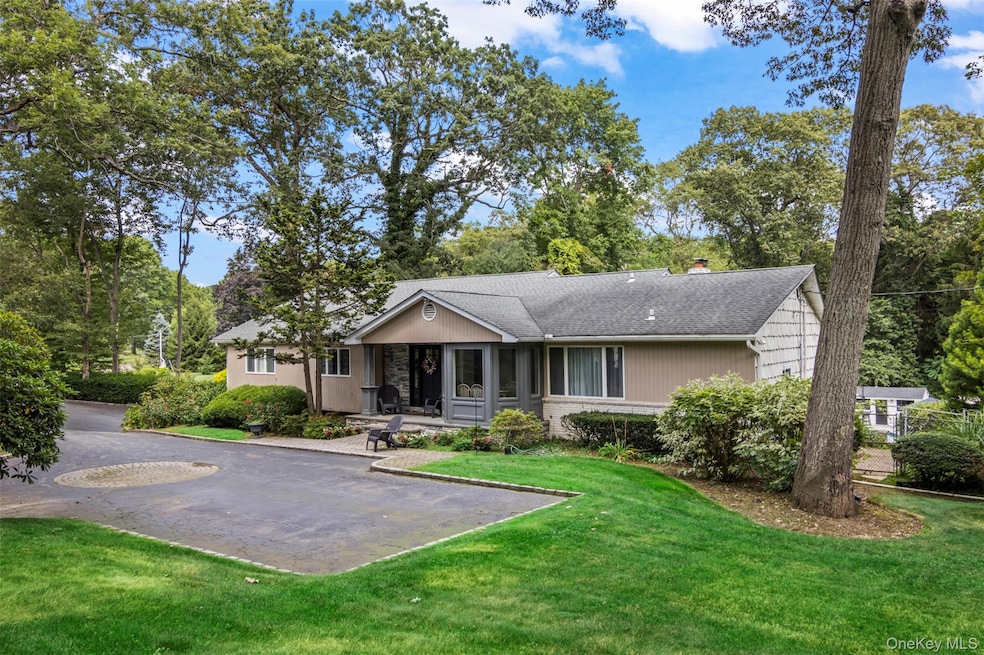
17 Plane Tree Ln Dix Hills, NY 11746
Estimated payment $8,571/month
Highlights
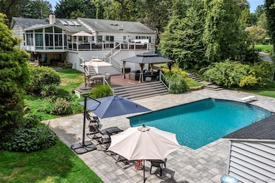
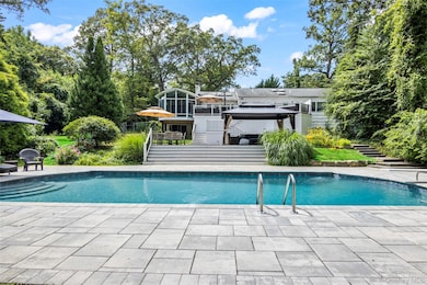
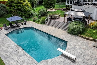
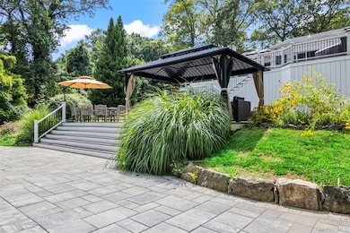
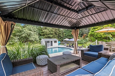
- Cabana
- Open Floorplan
- Vaulted Ceiling
- Signal Hill Elementary School Rated A
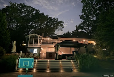
- Deck
- 2-Story Property
About This Home
Location, amenities and SPACE in this sprawling, single-story retreat nestled in the absolutely beautiful Caledonia section of Dix Hills. This remodeled, versatile, 3/4 bedroom home was designed with a spacious open floor plan, flexible living options and tons of natural light. Featuring vaulted ceilings and a double-sided fireplace, the large family room and sun room invite effortless indoor-outdoor living: sliding glass doors connect the interior to a multi-level deck and stunning, country club backyard — a landscaped full acre with heated pool, cabana, paver patio, dining and lounge areas! Ideal for entertaining in any season, the home's eat-in kitchen features an oversized island, granite countertops, stainless steel appliances, and ample storage. The primary suite offers a full bathroom with private access to the tiered deck, plus a massive walk-in closet. Additional bedrooms provide flexible accommodations for dwellers or guests. Highlights include new central A/C, young roof, recently converted gas heat, 2-car garage beneath the home, first floor laundry, radiant heated floors and a fabulous walk-out basement with garage access and outside entrance. Ideally located in one of Dix Hills' most serene, bucolic neighborhoods just minutes from Signal Hill Elementary, Hills East High School and St. Anthony's High School. Caledonia Park, Northern State Pkwy and Jericho Tpk are about a mile away. Experience the perfect combination of versatility, location, and lifestyle in one of the best buys in Dix Hills. Sold As Is. Hurry!
Listing Agent
Daniel Gale Sothebys Intl Rlty Brokerage Phone: 631-806-5439 License #10301208102 Listed on: 10/22/2025

Home Details
Home Type
- Single Family
Est. Annual Taxes
- $20,633
Year Built
- Built in 1965
Lot Details
- 1 Acre Lot
- Dog Run
- Landscaped
- Corner Lot
- Lot Has A Rolling Slope
- Front and Back Yard Sprinklers
- Back Yard Fenced
Parking
- 2 Car Garage
- Driveway
Home Design
- 2-Story Property
- Brick Exterior Construction
- Frame Construction
- Wood Siding
Interior Spaces
- 2,700 Sq Ft Home
- Open Floorplan
- Built-In Features
- Vaulted Ceiling
- Recessed Lighting
- Chandelier
- Wood Burning Fireplace
- Fireplace Features Masonry
- Entrance Foyer
- Living Room with Fireplace
- Formal Dining Room
- Storage
Kitchen
- Eat-In Kitchen
- Gas Oven
- Freezer
- Dishwasher
- Stainless Steel Appliances
- Kitchen Island
- Granite Countertops
Flooring
- Wood
- Carpet
- Radiant Floor
Bedrooms and Bathrooms
- 3 Bedrooms
- Main Floor Bedroom
- En-Suite Primary Bedroom
- Walk-In Closet
- In-Law or Guest Suite
- Bathroom on Main Level
Laundry
- Laundry Room
- Laundry in Hall
- Dryer
- Washer
Basement
- Walk-Out Basement
- Basement Fills Entire Space Under The House
Pool
- Cabana
- In Ground Pool
- Pool Cover
Outdoor Features
- Deck
- Fire Pit
- Exterior Lighting
- Porch
Location
- Property is near schools
Schools
- Signal Hill Elementary School
- West Hollow Middle School
- Half Hollow Hills High School East
Utilities
- Central Air
- Baseboard Heating
- Heating System Uses Natural Gas
- Natural Gas Connected
- Gas Water Heater
- Cesspool
Listing and Financial Details
- Assessor Parcel Number 0400-245-00-01-00-093-000
Map
Home Values in the Area
Average Home Value in this Area
Tax History
| Year | Tax Paid | Tax Assessment Tax Assessment Total Assessment is a certain percentage of the fair market value that is determined by local assessors to be the total taxable value of land and additions on the property. | Land | Improvement |
|---|---|---|---|---|
| 2024 | $19,569 | $5,150 | $650 | $4,500 |
| 2023 | $9,784 | $5,150 | $650 | $4,500 |
| 2022 | $20,972 | $5,900 | $650 | $5,250 |
| 2021 | $20,534 | $5,900 | $650 | $5,250 |
| 2020 | $20,317 | $5,900 | $650 | $5,250 |
| 2019 | $40,635 | $0 | $0 | $0 |
| 2018 | $19,229 | $5,900 | $650 | $5,250 |
| 2017 | $19,229 | $5,900 | $650 | $5,250 |
| 2016 | $18,797 | $5,900 | $650 | $5,250 |
| 2015 | -- | $5,900 | $650 | $5,250 |
| 2014 | -- | $6,200 | $650 | $5,550 |
Property History
| Date | Event | Price | List to Sale | Price per Sq Ft |
|---|---|---|---|---|
| 11/04/2025 11/04/25 | Pending | -- | -- | -- |
| 10/22/2025 10/22/25 | For Sale | $1,300,000 | -- | $481 / Sq Ft |
Purchase History
| Date | Type | Sale Price | Title Company |
|---|---|---|---|
| Bargain Sale Deed | $765,000 | Fidelity National Title | |
| Bargain Sale Deed | $765,000 | Fidelity National Title | |
| Bargain Sale Deed | $835,000 | Commonwealth Land Title Ins | |
| Bargain Sale Deed | $835,000 | Commonwealth Land Title Ins |
Mortgage History
| Date | Status | Loan Amount | Loan Type |
|---|---|---|---|
| Open | $76,500 | Credit Line Revolving | |
| Closed | $76,500 | Credit Line Revolving | |
| Open | $612,000 | New Conventional | |
| Closed | $612,000 | New Conventional | |
| Previous Owner | $500,000 | Purchase Money Mortgage |
Source: OneKey® MLS
MLS Number: 926647
APN: 0400-245-00-01-00-093-000
Disclaimer: Certain information contained herein is derived from information provided by parties other than Homes.com. All information provided is deemed reliable, but is not guaranteed to be accurate and should be independently verified.
![]() The data relating to real estate for sale or lease on this web site comes in part from OneKey® MLS. Real estate listings held by brokerage firms other than Ten-X are marked with the OneKey® MLS logo or an abbreviated logo and detailed information about them includes the name of the listing broker.
The data relating to real estate for sale or lease on this web site comes in part from OneKey® MLS. Real estate listings held by brokerage firms other than Ten-X are marked with the OneKey® MLS logo or an abbreviated logo and detailed information about them includes the name of the listing broker.
IDX information is provided exclusively for personal, non-commercial use, and may not be used for any purpose other than to identify prospective properties consumers may be interested in purchasing.
Information is deemed reliable but not guaranteed.
Copyright 2025 OneKey® MLS. All rights reserved.