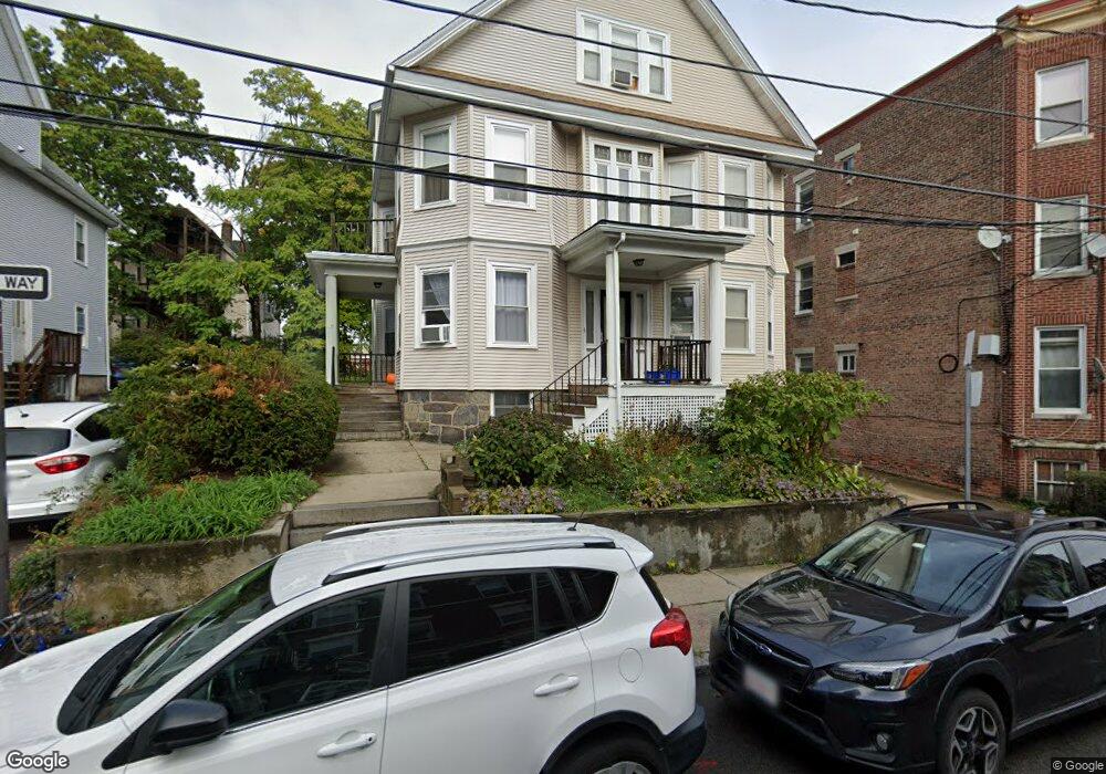
17 Price Rd Unit 19 Allston, MA 02134
Commonwealth NeighborhoodEstimated Value: $1,544,000 - $1,785,000
4
Beds
1
Bath
--
Sq Ft
4,617
Sq Ft Lot
About This Home
This home is located at 17 Price Rd Unit 19, Allston, MA 02134 and is currently estimated at $1,669,760. 17 Price Rd Unit 19 is a home located in Suffolk County with nearby schools including Match Charter Public School and Boston Green Academy Horace Mann Charter School.
Ownership History
Date
Name
Owned For
Owner Type
Purchase Details
Closed on
Oct 27, 2020
Sold by
Hui Edwin Y and Hui Bik T
Bought by
Hui Price Road Rt
Current Estimated Value
Create a Home Valuation Report for This Property
The Home Valuation Report is an in-depth analysis detailing your home's value as well as a comparison with similar homes in the area
Home Values in the Area
Average Home Value in this Area
Purchase History
| Date | Buyer | Sale Price | Title Company |
|---|---|---|---|
| Hui Price Road Rt | -- | None Available | |
| Hui Edwin Y | -- | None Available |
Source: Public Records
Tax History Compared to Growth
Tax History
| Year | Tax Paid | Tax Assessment Tax Assessment Total Assessment is a certain percentage of the fair market value that is determined by local assessors to be the total taxable value of land and additions on the property. | Land | Improvement |
|---|---|---|---|---|
| 2025 | $16,182 | $1,397,400 | $599,700 | $797,700 |
| 2024 | $14,847 | $1,362,100 | $450,800 | $911,300 |
| 2023 | $14,629 | $1,362,100 | $450,800 | $911,300 |
| 2022 | $13,473 | $1,238,300 | $409,900 | $828,400 |
| 2021 | $13,213 | $1,238,300 | $409,900 | $828,400 |
| 2020 | $12,498 | $1,183,500 | $353,900 | $829,600 |
| 2019 | $12,112 | $1,149,100 | $270,800 | $878,300 |
| 2018 | $11,359 | $1,083,900 | $270,800 | $813,100 |
| 2017 | $10,932 | $1,032,300 | $270,800 | $761,500 |
| 2016 | $9,961 | $905,500 | $270,800 | $634,700 |
| 2015 | $9,891 | $816,800 | $181,600 | $635,200 |
| 2014 | $8,767 | $696,900 | $181,600 | $515,300 |
Source: Public Records
Map
Nearby Homes
- 83 Glenville Ave
- 86 Glenville Ave Unit 2
- 14 Radcliffe Rd Unit 1
- 20 Radcliffe Rd Unit 209
- 20 Radcliffe Rd Unit 112
- 1304 Commonwealth Ave Unit 5
- 130 Glenville Ave
- 5 Spofford Rd Unit 17
- 30 Glenville Ave Unit 1
- 53 Quint Ave
- 85 Brainerd Rd Unit TH7
- 159-161 Allston
- 21 Park Vale Ave Unit 2
- 1408 Commonwealth Ave Unit 20
- 1419 Commonwealth Ave Unit 503
- 5 Fiske Terrace
- 178 Brighton Ave Unit 12
- 147 Kelton St Unit 305
- 239 Kelton St Unit 41
- 245 Kelton St Unit 21
- 17 Price Rd Unit 13
- 17 Price Rd Unit 10
- 17 Price Rd Unit 6
- 17 Price Rd Unit 4
- 17 Price Rd Unit 3
- 17 Price Rd Unit 2
- 17 Price Rd Unit 5
- 17 Price Rd Unit 16
- 17 Price Rd
- 17-19 Price Rd Unit 4
- 11 Price Rd Unit 1
- 11 Price Rd Unit 2
- 11 Price Rd
- 11 Price Rd Unit 4
- 11 Price Rd Unit 3
- 11 Price Rd Unit 5
- 19 Price Rd Unit 6
- 19 Price Rd Unit 5
- 19 Price Rd Unit 4
- 19 Price Rd Unit 2