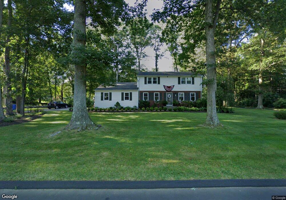
17 Rolling Meadow Rd Madison, CT 06443
Estimated Value: $612,499 - $728,000
4
Beds
2
Baths
2,076
Sq Ft
$318/Sq Ft
Est. Value
About This Home
This home is located at 17 Rolling Meadow Rd, Madison, CT 06443 and is currently estimated at $660,875, approximately $318 per square foot. 17 Rolling Meadow Rd is a home located in New Haven County with nearby schools including Walter C. Polson Upper Middle School, Daniel Hand High School, and Our Lady of Mercy Preparatory Academy.
Ownership History
Date
Name
Owned For
Owner Type
Purchase Details
Closed on
Aug 5, 2010
Sold by
Wade Patrick T
Bought by
Wade Linda P
Current Estimated Value
Purchase Details
Closed on
Feb 21, 2003
Sold by
Wade Linda P
Bought by
Wade Linda P and Wade Patrick I
Purchase Details
Closed on
Jul 20, 1998
Sold by
Knowlton Mary J
Bought by
Wade Patrick T and Wade Linda P
Create a Home Valuation Report for This Property
The Home Valuation Report is an in-depth analysis detailing your home's value as well as a comparison with similar homes in the area
Home Values in the Area
Average Home Value in this Area
Purchase History
| Date | Buyer | Sale Price | Title Company |
|---|---|---|---|
| Wade Linda P | -- | -- | |
| Wade Linda P | $92,466 | -- | |
| Wade Patrick T | $223,000 | -- |
Source: Public Records
Mortgage History
| Date | Status | Borrower | Loan Amount |
|---|---|---|---|
| Open | Wade Patrick T | $225,000 | |
| Closed | Wade Patrick T | $210,000 | |
| Previous Owner | Wade Patrick T | $205,000 |
Source: Public Records
Tax History
| Year | Tax Paid | Tax Assessment Tax Assessment Total Assessment is a certain percentage of the fair market value that is determined by local assessors to be the total taxable value of land and additions on the property. | Land | Improvement |
|---|---|---|---|---|
| 2025 | $7,442 | $331,800 | $133,600 | $198,200 |
| 2024 | $7,300 | $331,800 | $133,600 | $198,200 |
| 2023 | $6,941 | $231,600 | $102,800 | $128,800 |
| 2022 | $6,811 | $231,600 | $102,800 | $128,800 |
| 2021 | $6,682 | $231,600 | $102,800 | $128,800 |
| 2020 | $6,566 | $231,600 | $102,800 | $128,800 |
| 2019 | $6,566 | $231,600 | $102,800 | $128,800 |
| 2018 | $6,396 | $228,100 | $104,000 | $124,100 |
| 2017 | $6,227 | $228,100 | $104,000 | $124,100 |
| 2016 | $6,042 | $228,100 | $104,000 | $124,100 |
| 2015 | $5,876 | $228,100 | $104,000 | $124,100 |
| 2014 | $7,168 | $284,800 | $150,600 | $134,200 |
Source: Public Records
Map
Nearby Homes
- 461 Green Hill Rd
- 42 Wildcat Rd
- 18 Kelsey Springs Dr
- 90 Robin Ridge Dr
- 75 Fairview Dr
- 38 Sportsman Hill Rd
- 462 Horse Pond Rd
- 696 Green Hill Rd
- 0 Skytop Dr
- 81 Strawberry Hill Rd
- 162 Yankee Peddler Path
- 743 Green Hill Rd
- 14 Centre Village Dr
- 40 Puritan Ln
- 198 Green Hill Rd
- 38 Opening Hill Rd
- 24 Railroad Ave
- 26 Opening Hill Rd
- 30 Meeting House Ln
- 92 Scotland Ave
- 11 Beaver Pond Rd
- 319 Durham Rd
- 12 Rolling Meadow Rd
- 18 Rolling Meadow Rd
- 311 Durham Rd
- 6 Rolling Meadow Rd
- 24 Rolling Meadow Rd
- 15 Beaver Pond Rd
- 26 Beaver Pond Rd
- 33 Rolling Meadow Rd
- 361 Durham Rd
- 30 Rolling Meadow Rd
- 123 Randi Dr
- 303 Durham Rd
- 484 Green Hill Rd
- 30 Beaver Pond Rd
- 492 Green Hill Rd
- 478 Green Hill Rd
- 39 Rolling Meadow Rd
- 496 Green Hill Rd
Your Personal Tour Guide
Ask me questions while you tour the home.