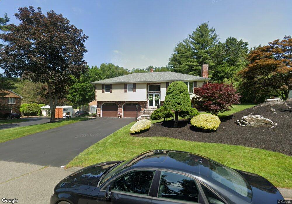
17 Stillings Rd Saugus, MA 01906
North Saugus NeighborhoodEstimated Value: $947,791 - $1,266,000
3
Beds
3
Baths
2,488
Sq Ft
$445/Sq Ft
Est. Value
About This Home
This home is located at 17 Stillings Rd, Saugus, MA 01906 and is currently estimated at $1,106,198, approximately $444 per square foot. 17 Stillings Rd is a home located in Essex County with nearby schools including Saugus High School, Pioneer Charter School Of Science II, and Odyssey Day School.
Ownership History
Date
Name
Owned For
Owner Type
Purchase Details
Closed on
Jan 8, 2003
Sold by
Crombie Michael
Bought by
Crombie Michael L
Current Estimated Value
Purchase Details
Closed on
Sep 28, 2001
Sold by
Benson Michael R and Benson Karen M
Bought by
Crombie Michael L
Purchase Details
Closed on
Oct 14, 1993
Sold by
Dellorfano Ralph
Bought by
Benson Michael R and Benosn Karen
Purchase Details
Closed on
Jun 26, 1992
Sold by
Sully Richard J
Bought by
Dellorfano Ralph W
Create a Home Valuation Report for This Property
The Home Valuation Report is an in-depth analysis detailing your home's value as well as a comparison with similar homes in the area
Home Values in the Area
Average Home Value in this Area
Purchase History
| Date | Buyer | Sale Price | Title Company |
|---|---|---|---|
| Crombie Michael L | -- | -- | |
| Crombie Michael L | $447,000 | -- | |
| Benson Michael R | $210,000 | -- | |
| Dellorfano Ralph W | $200,000 | -- |
Source: Public Records
Mortgage History
| Date | Status | Borrower | Loan Amount |
|---|---|---|---|
| Open | Dellorfano Ralph W | $149,900 | |
| Closed | Dellorfano Ralph W | $74,500 |
Source: Public Records
Tax History Compared to Growth
Tax History
| Year | Tax Paid | Tax Assessment Tax Assessment Total Assessment is a certain percentage of the fair market value that is determined by local assessors to be the total taxable value of land and additions on the property. | Land | Improvement |
|---|---|---|---|---|
| 2025 | $9,524 | $891,800 | $455,200 | $436,600 |
| 2024 | $9,222 | $865,900 | $440,200 | $425,700 |
| 2023 | $8,470 | $752,200 | $355,200 | $397,000 |
| 2022 | $8,064 | $671,400 | $308,200 | $363,200 |
| 2021 | $8,041 | $651,600 | $289,200 | $362,400 |
| 2020 | $7,605 | $638,000 | $289,200 | $348,800 |
| 2019 | $7,575 | $621,900 | $289,200 | $332,700 |
| 2018 | $7,068 | $610,400 | $289,200 | $321,200 |
| 2017 | $6,756 | $560,700 | $275,200 | $285,500 |
| 2016 | $7,341 | $601,700 | $275,400 | $326,300 |
| 2015 | $6,886 | $572,900 | $262,200 | $310,700 |
| 2014 | $6,282 | $541,100 | $262,200 | $278,900 |
Source: Public Records
Map
Nearby Homes
- 9 Broadway Unit 305
- 8 & 14 Sherbrooke Terrace
- 201 Water St
- 5 Hobson St
- 527 Salem St Unit 42
- 18 Walton St
- 905 Sherwood Forest Ln
- 14 Sycamore Rd
- 227 Walnut St
- 344 Broadway
- 695 Salem St
- 244 Moulton Dr
- 70 Old Nahant Rd
- 960 Summer St
- 9 Nelson Ave
- 29 Susan Dr
- 9 Thomas St Unit 11
- 1 Millbrook Ln Unit 304
- 148 Forest St
- 6 Castle Clare Cir
- 15 Stillings Rd
- 19 Stillings Rd
- 11 Stillings Rd
- 16 Stillings Rd
- 6 Pine Tree Dr
- 12 Stillings Rd
- 18 Stillings Rd
- 14 Stillings Rd
- 21 Stillings Rd
- 8 Pine Tree Dr
- 29R Butterfield Rd
- 9 Stillings Rd
- 10 Stillings Rd
- 10 Pine Tree Dr
- 8 Stillings Rd
- 27 Arrowhead Dr
- 25 Stillings Rd
- 29 Arrowhead Dr
- 9 Pine Tree Dr
- 5 Pine Tree Dr