
Seller's Agent in 2026
Robert Dekanski
RE/MAX
(800) 691-0485
4 in this area
2,478 Total Sales
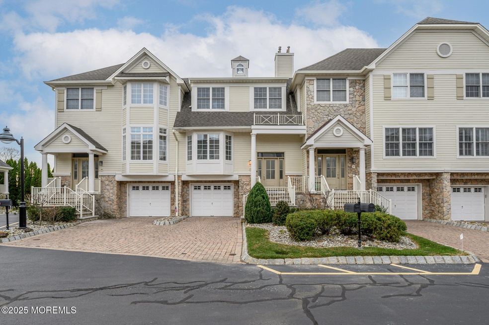


Excelsior Al Mare in highly desirable Long Branch premieres this stunning 3 Bed 2.5 Bath Turn-Key Townhome with Master Suite, Newly Renovated Kitchen, and 1 Car Garage, just one block from the ocean! Well above sea level in a prime shore location, meticulously maintained inside and out with curb appeal and plenty of modern upgrades all through, move-in-ready and waiting for you! This gorgeous home welcomes you in through a sleek tiled foyer to find a spacious and sophisticated interior with generous room sizes, custom built-ins, recessed lighting, luxury hardwood floors that shine, and a crisp neutral palette throughout that is easy to customize. The light and bright main level features an accessible open floor plan for seamless living and entertaining. Lovely living room is adorned with crisp crown molding, a cozy gas fireplace that is perfect for the season, and italian floating shelves with bar. Dual sliders off the living/dining combo open to your own private balcony with natural gas bbq, perfect for al fresco dining. Newly renovated eat-in-kitchen will delight any home chef, offering sleek SS appliances, upgraded counters, custom built-in solid walnut cabinetry, delightful breakfast bar and sun soaked dinette space. Upstairs, find the main full bath along with 3 generous bedrooms with ample California closets, inc the blissful Master Suite. MBR boasts its own walk-in closet, private upper balcony, and luxurious remodeled ensuite bath with dual sinks, stall shower, and relaxing jacuzzi tub. In-unit laundry with wall mounted built-in ironing center adds to the package. Finished lower level holds a convenient 1/2 bath, laundry room, and large family room/media room that offers a 2nd gas fireplace with custom stone wall surround. Oversized 1 car garage with wide paver driveway offers addtl California closets, cabinets, wall shelf, and oversized loft storage. Central air/forced heat, central vaccuum, community outdoor pool, the list goes on! All in a highly sought after shore location, just steps to the beach and serene ocean views, shopping, dining, Monmouth Medical Center and more. Don't miss out on this move-in-ready MUST SEE! Claim your slice of Long Branch today!
Last Agent to Sell the Property
RE/MAX 1st. Advantage License #0232901 Listed on: 11/14/2025
Last Buyer's Agent
NON MEMBER MORR
NON MEMBER
| Date | Type | Sale Price | Title Company |
|---|---|---|---|
| Deed | $730,000 | None Available | |
| Deed | $716,000 | -- | |
| Deed | $480,608 | -- |
| Date | Status | Loan Amount | Loan Type |
|---|---|---|---|
| Open | $417,000 | Purchase Money Mortgage | |
| Previous Owner | $572,800 | Adjustable Rate Mortgage/ARM | |
| Previous Owner | $300,000 | No Value Available |
| Date | Event | Price | List to Sale | Price per Sq Ft |
|---|---|---|---|---|
| 03/19/2026 03/19/26 | Sold | $1,250,000 | 0.0% | $516 / Sq Ft |
| 01/12/2026 01/12/26 | Pending | -- | -- | -- |
| 11/14/2025 11/14/25 | For Sale | $1,250,000 | -- | $516 / Sq Ft |
| Year | Tax Paid | Tax Assessment Tax Assessment Total Assessment is a certain percentage of the fair market value that is determined by local assessors to be the total taxable value of land and additions on the property. | Land | Improvement |
|---|---|---|---|---|
| 2025 | $14,140 | $1,079,300 | $635,000 | $444,300 |
| 2024 | $13,834 | $920,000 | $495,000 | $425,000 |
| 2023 | $13,834 | $890,800 | $480,000 | $410,800 |
| 2022 | $14,744 | $776,400 | $410,000 | $366,400 |
| 2021 | $14,744 | $736,900 | $390,000 | $346,900 |
| 2020 | $14,176 | $678,300 | $325,000 | $353,300 |
| 2019 | $13,997 | $665,900 | $325,000 | $340,900 |
| 2018 | $13,895 | $657,300 | $325,000 | $332,300 |
| 2017 | $13,081 | $634,700 | $305,000 | $329,700 |
| 2016 | $12,730 | $629,900 | $305,000 | $324,900 |
| 2015 | $11,440 | $513,700 | $175,000 | $338,700 |
| 2014 | $11,854 | $561,000 | $230,000 | $331,000 |
Seller's Agent in 2026
Robert Dekanski
RE/MAX
(800) 691-0485
4 in this area
2,478 Total Sales
N
Buyer's Agent in 2026
NON MEMBER MORR
NON MEMBER
Source: MOREMLS (Monmouth Ocean Regional REALTORS®)
MLS Number: 22534538
APN: 27-00152-0000-00018-17
Disclaimer: Certain information contained herein is derived from information provided by parties other than Homes.com. All information provided is deemed reliable, but is not guaranteed to be accurate and should be independently verified.
![]() IDX information is provided exclusively for personal, non-commercial use, and may not be used for any purpose other than to identify prospective properties consumers may be interested in purchasing.
IDX information is provided exclusively for personal, non-commercial use, and may not be used for any purpose other than to identify prospective properties consumers may be interested in purchasing.
Information is deemed reliable but not guaranteed.
Ask me questions while you tour the home.