17 Underwood Ln Middletown, RI 02842
Estimated payment $3,291/month
Highlights
- Hot Property
- Water Views
- Cape Cod Architecture
- Marina
- Golf Course Community
- Wood Flooring
About This Home
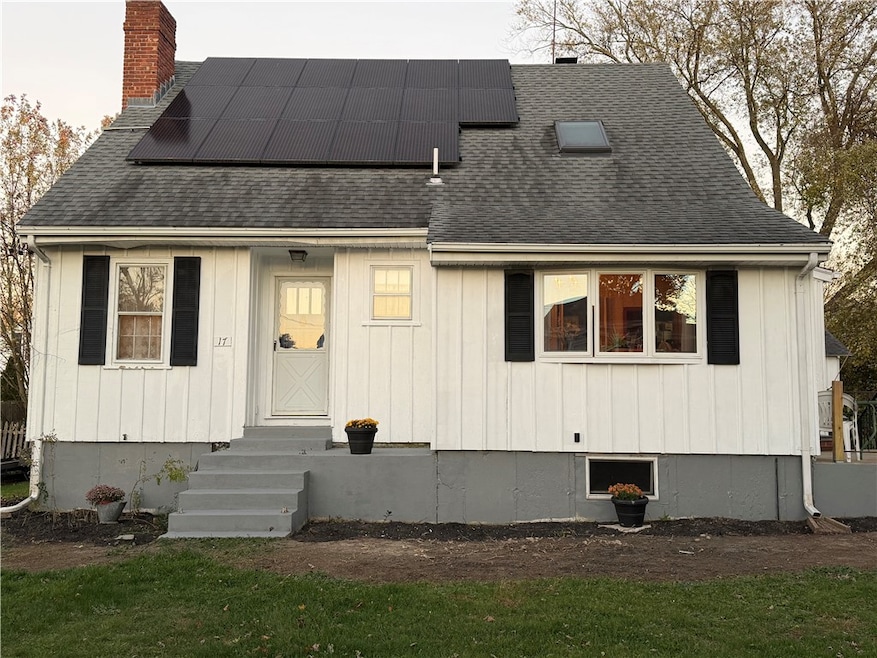
Opportunity awaits near Newport! This spacious 4-bedroom, 3-bath home offers a prime location just minutes from the Newport Bridge, making commuting a breeze. Enjoy the convenience of walking to local favorites like Coddington Brewing Company, right down the street. Inside, the first floor features two bedrooms and a full bath, while the upstairs primary suite boasts stunning water views and private deck access. An additional bedroom and full bath complete the second level, along with a generous living area perfect for relaxation or entertaining. Recent updates include a young roof with solar panels and a newer furnace, adding efficiency and peace of mind. With a few personal touches, this property offers excellent potential for instant equity. Professional photos coming soon.
Open House Schedule
-
Sunday, November 16, 202511:00 am to 1:00 pm11/16/2025 11:00:00 AM +00:0011/16/2025 1:00:00 PM +00:00Add to Calendar
Home Details
Home Type
- Single Family
Est. Annual Taxes
- $6,288
Year Built
- Built in 1947
Lot Details
- 8,276 Sq Ft Lot
Parking
- 1 Car Detached Garage
Home Design
- Cape Cod Architecture
- Wood Siding
- Concrete Perimeter Foundation
- Clapboard
- Plaster
Interior Spaces
- 2,167 Sq Ft Home
- 2-Story Property
- Fireplace Features Masonry
- Water Views
- Storm Doors
- Laundry Room
Flooring
- Wood
- Carpet
Bedrooms and Bathrooms
- 4 Bedrooms
- Bathtub with Shower
Unfinished Basement
- Basement Fills Entire Space Under The House
- Interior and Exterior Basement Entry
Utilities
- No Cooling
- Heating System Uses Oil
- Hot Water Heating System
- Heating System Uses Steam
- Oil Water Heater
Listing and Financial Details
- Tax Lot 66
- Assessor Parcel Number 17UNDERWOODLANEMDLT
Community Details
Amenities
- Shops
- Restaurant
- Public Transportation
Recreation
- Marina
- Golf Course Community
- Tennis Courts
Map
Home Values in the Area
Average Home Value in this Area
Tax History
| Year | Tax Paid | Tax Assessment Tax Assessment Total Assessment is a certain percentage of the fair market value that is determined by local assessors to be the total taxable value of land and additions on the property. | Land | Improvement |
|---|---|---|---|---|
| 2025 | $6,288 | $533,300 | $298,100 | $235,200 |
| 2024 | $6,005 | $533,300 | $298,100 | $235,200 |
| 2023 | $4,962 | $394,100 | $201,500 | $192,600 |
| 2022 | $4,737 | $394,100 | $201,500 | $192,600 |
| 2021 | $4,737 | $394,100 | $201,500 | $192,600 |
| 2020 | $4,380 | $318,300 | $151,300 | $167,000 |
| 2018 | $4,377 | $318,300 | $151,300 | $167,000 |
| 2016 | $4,765 | $309,000 | $135,500 | $173,500 |
| 2015 | $4,647 | $309,000 | $135,500 | $173,500 |
| 2014 | $4,638 | $288,600 | $116,300 | $172,300 |
| 2013 | $4,534 | $288,600 | $116,300 | $172,300 |
Property History
| Date | Event | Price | List to Sale | Price per Sq Ft |
|---|---|---|---|---|
| 11/13/2025 11/13/25 | For Sale | $525,000 | -- | $242 / Sq Ft |
Purchase History
| Date | Type | Sale Price | Title Company |
|---|---|---|---|
| Deed | -- | -- |
Mortgage History
| Date | Status | Loan Amount | Loan Type |
|---|---|---|---|
| Open | $158,895 | No Value Available | |
| Closed | $99,000 | No Value Available | |
| Closed | $195,900 | No Value Available |
Source: State-Wide MLS
MLS Number: 1399972
APN: MIDD-000107-S000000W-000066
Disclaimer: Certain information contained herein is derived from information provided by parties other than Homes.com. All information provided is deemed reliable, but is not guaranteed to be accurate and should be independently verified.
![]() IDX information is provided exclusively for personal, non-commercial use, and may not be used for any purpose other than to identify prospective properties consumers may be interested in purchasing. Information is deemed reliable but not guaranteed.
IDX information is provided exclusively for personal, non-commercial use, and may not be used for any purpose other than to identify prospective properties consumers may be interested in purchasing. Information is deemed reliable but not guaranteed.
Copyright © 2025 State-Wide MLS, Inc. All rights reserved.
- 114 Maple Ave
- 65 Maple Ave
- 16 King Rd
- 17 Mariner Way
- 67 Linden St
- 231 Maple Ave Unit 204
- 10 Evergreen Ave
- 149 W Main Rd
- 117 W Main Rd
- 66 Girard Ave Unit 401
- 66 Girard Ave Unit 312
- 74 Valley Rd
- 203 N Fenner Ave Unit 5
- 6 Wabasso Terrace
- 5 Elliot Place
- 1 Shangri-La Ln
- 138 Green End Ave
- 155 Evarts St
- 7 Sheffield Ave Unit A
- 7 Sheffield Ave Unit B
- 131 Lake Erie St
- 59 John H Chafee Blvd
- 12 Granada Terrace
- 137 W Main Rd Unit REAR
- 190 E Main Rd Unit 3
- 66 Girard Ave Unit 114
- 66 Girard Ave Unit 417
- 66 Girard Ave Unit 309
- 16 Dudley Ave Unit 7
- 40 Harbor Village Dr
- 52 Bedlow Ave
- 46 Thurston Ave
- 6 Restmere Terrace
- 5 Restmere Terrace
- 18 Bedlow Ave
- 30 Thurston Ave Unit 1
- 23 Smith Ave Unit 3
- 26 Vernon Ave
- 5 Elliot Place Unit 1
- 41 Freeborn St Unit 1
