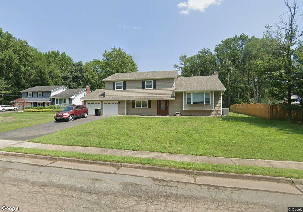
17 Wylie Terrace Morganville, NJ 07751
Estimated Value: $676,276
4
Beds
3
Baths
2,217
Sq Ft
$305/Sq Ft
Est. Value
About This Home
This home is located at 17 Wylie Terrace, Morganville, NJ 07751 and is currently estimated at $676,276, approximately $305 per square foot. 17 Wylie Terrace is a home located in Monmouth County with nearby schools including Robertsville Elementary School, Marlboro Memorial Middle School, and Marlboro High School.
Ownership History
Date
Name
Owned For
Owner Type
Purchase Details
Closed on
Sep 20, 2017
Sold by
Mizarahi Roger
Bought by
Filippo Louis and Filippo Maria
Current Estimated Value
Purchase Details
Closed on
Oct 4, 2016
Sold by
Bank Of America Na and Keating Robert T
Bought by
Mizrahi Roger
Purchase Details
Closed on
Oct 29, 2008
Sold by
Marks Arlyne
Bought by
Keating Robert T and Keating Robyn A
Home Financials for this Owner
Home Financials are based on the most recent Mortgage that was taken out on this home.
Original Mortgage
$391,500
Interest Rate
6.13%
Mortgage Type
Purchase Money Mortgage
Purchase Details
Closed on
Jan 19, 2007
Sold by
Marks Barry
Bought by
Marks Barry
Home Financials for this Owner
Home Financials are based on the most recent Mortgage that was taken out on this home.
Original Mortgage
$544,185
Interest Rate
6.53%
Mortgage Type
Reverse Mortgage Home Equity Conversion Mortgage
Create a Home Valuation Report for This Property
The Home Valuation Report is an in-depth analysis detailing your home's value as well as a comparison with similar homes in the area
Home Values in the Area
Average Home Value in this Area
Purchase History
| Date | Buyer | Sale Price | Title Company |
|---|---|---|---|
| Filippo Louis | $415,000 | -- | |
| Mizrahi Roger | $273,000 | None Available | |
| Keating Robert T | $435,000 | Stewart Title Guaranty Co | |
| Marks Barry | -- | -- |
Source: Public Records
Mortgage History
| Date | Status | Borrower | Loan Amount |
|---|---|---|---|
| Previous Owner | Keating Robert T | $391,500 | |
| Previous Owner | Marks Barry | $544,185 |
Source: Public Records
Tax History Compared to Growth
Tax History
| Year | Tax Paid | Tax Assessment Tax Assessment Total Assessment is a certain percentage of the fair market value that is determined by local assessors to be the total taxable value of land and additions on the property. | Land | Improvement |
|---|---|---|---|---|
| 2025 | -- | $378,400 | $183,000 | $195,400 |
| 2024 | -- | $378,400 | $183,000 | $195,400 |
| 2023 | -- | $378,400 | $183,000 | $195,400 |
| 2022 | $0 | $378,400 | $183,000 | $195,400 |
| 2021 | $8,438 | $378,400 | $183,000 | $195,400 |
| 2020 | $0 | $378,400 | $183,000 | $195,400 |
| 2019 | $8,438 | $378,400 | $183,000 | $195,400 |
| 2018 | $0 | $378,400 | $183,000 | $195,400 |
| 2017 | $8,438 | $378,400 | $183,000 | $195,400 |
| 2016 | $8,408 | $378,400 | $183,000 | $195,400 |
| 2015 | $8,172 | $373,300 | $183,000 | $190,300 |
| 2014 | $8,223 | $371,900 | $203,000 | $168,900 |
Source: Public Records
Map
Nearby Homes
- 41 Guest Dr
- 5 Claytons Ln
- 533 Texas Rd
- 608 Texas Rd
- 1207 Marlboro Rd
- 22 Bartram Rd
- 24 Bartram Rd
- 1 Texas Rd
- 5 Valentino Dr
- 15 Valentino Dr
- 11 Rowena Rd
- 519 Union Hill Rd
- 521 Union Hill Rd
- 167 Valentino Dr
- 165 Valentino Dr
- 201 Forsythia Ln
- 157 Valentino Dr
- 28 Aspen Ave
- 26 Meadow Green Cir Unit K
- 0-0 Union Hill Rd