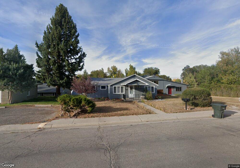
170 Custer St Lander, WY 82520
Estimated Value: $327,000 - $656,000
5
Beds
4
Baths
3,188
Sq Ft
$157/Sq Ft
Est. Value
About This Home
This home is located at 170 Custer St, Lander, WY 82520 and is currently estimated at $501,569, approximately $157 per square foot. 170 Custer St is a home located in Fremont County with nearby schools including Lander Valley High School and Lander Christian Academy.
Ownership History
Date
Name
Owned For
Owner Type
Purchase Details
Closed on
Feb 20, 2009
Sold by
Oliver John F and Oliver Jacquelyn R
Bought by
Oliver John F and Oliver Jacquelyn R
Current Estimated Value
Purchase Details
Closed on
Feb 21, 2006
Sold by
Oliver John F and Oliver Jacqulyn R
Bought by
Oliver John F and Oliver Jacquelyn R
Home Financials for this Owner
Home Financials are based on the most recent Mortgage that was taken out on this home.
Original Mortgage
$147,350
Interest Rate
6.1%
Mortgage Type
New Conventional
Create a Home Valuation Report for This Property
The Home Valuation Report is an in-depth analysis detailing your home's value as well as a comparison with similar homes in the area
Home Values in the Area
Average Home Value in this Area
Purchase History
| Date | Buyer | Sale Price | Title Company |
|---|---|---|---|
| Oliver John F | -- | Fremont County Title | |
| Oliver John F | -- | None Available |
Source: Public Records
Mortgage History
| Date | Status | Borrower | Loan Amount |
|---|---|---|---|
| Closed | Oliver John F | $147,350 |
Source: Public Records
Tax History
| Year | Tax Paid | Tax Assessment Tax Assessment Total Assessment is a certain percentage of the fair market value that is determined by local assessors to be the total taxable value of land and additions on the property. | Land | Improvement |
|---|---|---|---|---|
| 2025 | $4,167 | $38,236 | $4,256 | $33,980 |
| 2024 | $4,167 | $53,988 | $6,229 | $47,759 |
| 2023 | $3,945 | $51,524 | $5,689 | $45,835 |
| 2022 | $2,682 | $35,801 | $5,689 | $30,112 |
| 2021 | $2,376 | $30,699 | $5,321 | $25,378 |
| 2020 | $2,284 | $29,566 | $5,321 | $24,245 |
| 2019 | $2,263 | $28,820 | $5,321 | $23,499 |
| 2018 | $2,201 | $27,729 | $5,321 | $22,408 |
| 2017 | $2,155 | $27,079 | $5,321 | $21,758 |
| 2016 | $2,907 | $36,586 | $5,321 | $31,265 |
| 2015 | $2,824 | $35,946 | $5,321 | $30,625 |
| 2014 | $2,540 | $32,388 | $5,321 | $27,067 |
Source: Public Records
Map
Nearby Homes
- 975 S 2nd St
- 275 Cascade St
- 685 Cedar St
- 1520 Rodeo Dr
- 400 S 1st St
- 108 Canyon St
- 2 Dale Dr
- 348 Del St
- 350 Canyon St
- 316 Del St
- 1396 Mortimore Ln
- 2021 Hillcrest Dr
- 0 E Main (17 1 + - Acres) Unit 20256293
- 796 Welch Blvd
- 617 Main St Unit LotWP001
- 835 Garfield St
- 960 Dabich Ave
- 824 Main St
- 625 Cottonwood Ln
- 1100 Pronghorn Dr
- 140 Custer St
- 167 Capitol St
- 167 Capitol St Unit S. 2nd St
- 132 Custer St
- 1144 S 2nd St
- 143 Capitol St
- 155 Custer St
- 155 Custer St Unit S. 2nd St
- 210 Custer St
- 133 Capitol St
- 175 Custer St
- 149 Custer St
- 118 Custer St
- 1191 S 2nd St
- 123 Capitol St
- 1123 S 2nd St
- 127 Custer St
- 115 Capitol St
- 104 Custer St
- 1076 S 2nd St
Your Personal Tour Guide
Ask me questions while you tour the home.