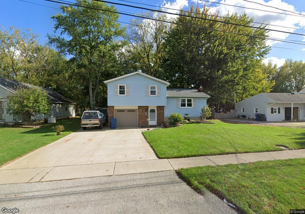
170 Railroad St Lagrange, OH 44050
Estimated Value: $189,323 - $278,000
3
Beds
1
Bath
1,316
Sq Ft
$172/Sq Ft
Est. Value
About This Home
This home is located at 170 Railroad St, Lagrange, OH 44050 and is currently estimated at $226,331, approximately $171 per square foot. 170 Railroad St is a home located in Lorain County with nearby schools including Keystone Elementary School, Keystone Middle School, and Keystone High School.
Ownership History
Date
Name
Owned For
Owner Type
Purchase Details
Closed on
May 6, 2024
Sold by
Stromack Stephen G
Bought by
Stromack Cynthia A
Current Estimated Value
Purchase Details
Closed on
Jan 24, 2001
Sold by
Patalon M V
Bought by
Stromack Stephen and Stromack Cynthia
Home Financials for this Owner
Home Financials are based on the most recent Mortgage that was taken out on this home.
Original Mortgage
$68,000
Interest Rate
10%
Create a Home Valuation Report for This Property
The Home Valuation Report is an in-depth analysis detailing your home's value as well as a comparison with similar homes in the area
Home Values in the Area
Average Home Value in this Area
Purchase History
| Date | Buyer | Sale Price | Title Company |
|---|---|---|---|
| Stromack Cynthia A | -- | None Listed On Document | |
| Stromack Stephen | -- | Ticorp National Title Agency |
Source: Public Records
Mortgage History
| Date | Status | Borrower | Loan Amount |
|---|---|---|---|
| Previous Owner | Stromack Stephen | $68,000 |
Source: Public Records
Tax History
| Year | Tax Paid | Tax Assessment Tax Assessment Total Assessment is a certain percentage of the fair market value that is determined by local assessors to be the total taxable value of land and additions on the property. | Land | Improvement |
|---|---|---|---|---|
| 2024 | $2,450 | $56,697 | $7,711 | $48,986 |
| 2023 | $2,472 | $47,779 | $8,271 | $39,508 |
| 2022 | $2,456 | $47,779 | $8,271 | $39,508 |
| 2021 | $2,457 | $47,779 | $8,271 | $39,508 |
| 2020 | $2,241 | $38,840 | $6,720 | $32,120 |
| 2019 | $2,229 | $38,840 | $6,720 | $32,120 |
| 2018 | $2,180 | $38,840 | $6,720 | $32,120 |
| 2017 | $2,203 | $37,140 | $4,930 | $32,210 |
| 2016 | $2,189 | $37,140 | $4,930 | $32,210 |
| 2015 | $2,187 | $37,140 | $4,930 | $32,210 |
| 2014 | $1,784 | $32,580 | $4,320 | $28,260 |
| 2013 | $1,650 | $32,580 | $4,320 | $28,260 |
Source: Public Records
Map
Nearby Homes
- 110 Railroad St
- 0 Dill Ct Unit 5072837
- 317 Church St
- 305 W Main St
- 516 Appomattox Ct
- 548 William St
- 567 Vicksburg Ct
- 340 Granger Dr
- 808 Buckingham Dr
- 800 Buckingham Dr
- 801 Willich Ct
- 40260 Whitney Rd
- 829 Robinson Dr
- 42113 Meadow Ln
- 704 Black Bear Run
- 17058 Chamberlain Rd
- 510 Arabian Ct
- 479 Stallion Ct
- 476 Stallion Ct
- 468 Stallion Ct
- 180 Railroad St
- 166 Railroad St
- 166 Railroad St
- 179 Railroad St
- 164 Railroad St
- 192 Railroad St
- 150 Railroad St
- 148 Railroad St
- 196 Railroad St
- 0 E Main St Unit 654389
- 0 E Main St Unit 5034169
- 0 E Main St Unit 5010994
- 0 E Main St Unit 4474022
- 167 Railroad St
- 118120 E Main St
- 146 Railroad St
- 198 Railroad St
- 86 Church St
- 88 Church St
- 303 E Main St
Your Personal Tour Guide
Ask me questions while you tour the home.