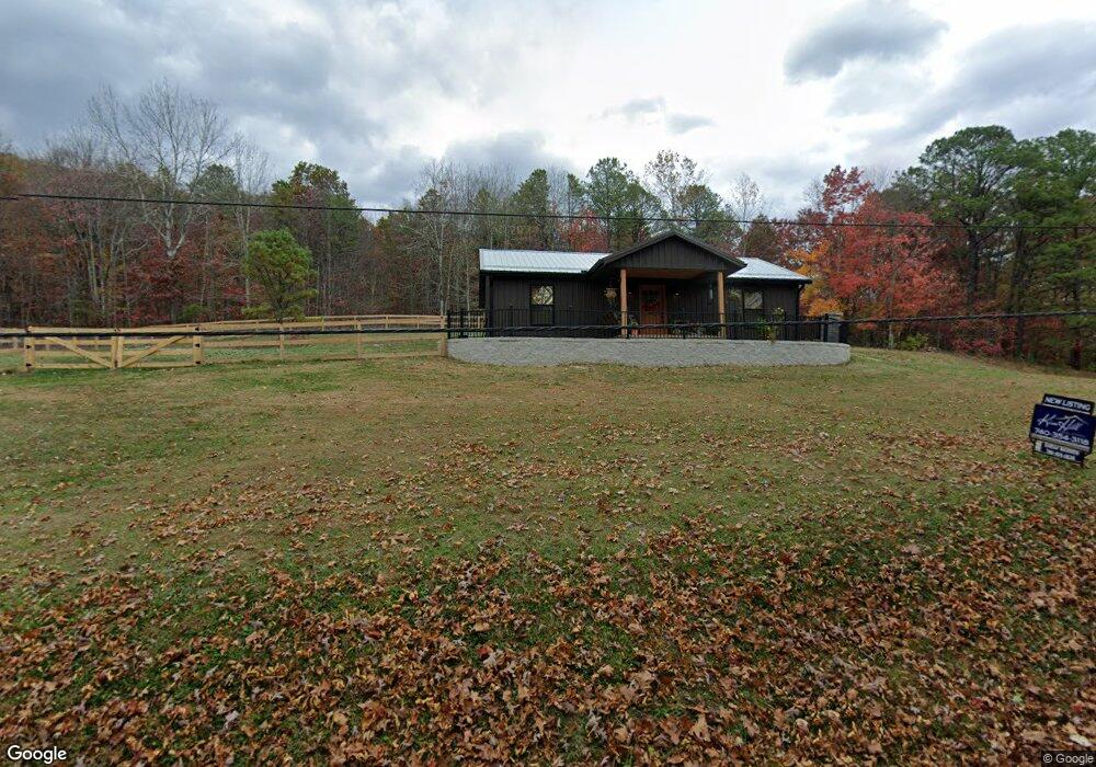
170 Wrights Run Rd Mc Dermott, OH 45652
Estimated Value: $215,000 - $270,000
2
Beds
2
Baths
1,040
Sq Ft
$229/Sq Ft
Est. Value
About This Home
This home is located at 170 Wrights Run Rd, Mc Dermott, OH 45652 and is currently estimated at $238,505, approximately $229 per square foot. 170 Wrights Run Rd is a home located in Scioto County with nearby schools including Northwest Elementary School, Northwest Middle School, and Northwest High School.
Ownership History
Date
Name
Owned For
Owner Type
Purchase Details
Closed on
Feb 9, 2024
Sold by
Wolfe Nathan A and Wolfe Rochel L
Bought by
Allen Benjamin and Allen Ana
Current Estimated Value
Home Financials for this Owner
Home Financials are based on the most recent Mortgage that was taken out on this home.
Original Mortgage
$168,900
Outstanding Balance
$165,910
Interest Rate
6.6%
Mortgage Type
New Conventional
Estimated Equity
$72,595
Purchase Details
Closed on
May 17, 2019
Sold by
Vice Roxanne and Vice Kevin Scott
Bought by
Wolfe Nathan A and Wolfe Rochel L
Purchase Details
Closed on
Dec 15, 2017
Sold by
Ferguson Donald J and Ferguson Alisha D
Bought by
Vice Roxanne
Purchase Details
Closed on
Jun 24, 1996
Bought by
Ferguson Donald J
Create a Home Valuation Report for This Property
The Home Valuation Report is an in-depth analysis detailing your home's value as well as a comparison with similar homes in the area
Home Values in the Area
Average Home Value in this Area
Purchase History
| Date | Buyer | Sale Price | Title Company |
|---|---|---|---|
| Allen Benjamin | $229,900 | None Listed On Document | |
| Wolfe Nathan A | $20,000 | None Available | |
| Vice Roxanne | $38,000 | -- | |
| Ferguson Donald J | $28,000 | -- |
Source: Public Records
Mortgage History
| Date | Status | Borrower | Loan Amount |
|---|---|---|---|
| Open | Allen Benjamin | $168,900 |
Source: Public Records
Tax History Compared to Growth
Tax History
| Year | Tax Paid | Tax Assessment Tax Assessment Total Assessment is a certain percentage of the fair market value that is determined by local assessors to be the total taxable value of land and additions on the property. | Land | Improvement |
|---|---|---|---|---|
| 2024 | $1,403 | $34,730 | $4,170 | $30,560 |
| 2023 | $1,403 | $4,330 | $4,170 | $160 |
| 2022 | $169 | $4,330 | $4,170 | $160 |
| 2021 | $145 | $3,730 | $3,600 | $130 |
| 2020 | $145 | $3,730 | $3,600 | $130 |
| 2019 | $545 | $13,080 | $3,570 | $9,510 |
| 2018 | $528 | $13,080 | $3,570 | $9,510 |
| 2017 | $631 | $13,080 | $3,570 | $9,510 |
| 2016 | $2,282 | $12,800 | $3,270 | $9,530 |
| 2015 | $525 | $12,800 | $3,270 | $9,530 |
| 2013 | $465 | $12,800 | $3,270 | $9,530 |
Source: Public Records
Map
Nearby Homes
- 656 Arion Rd
- 0 Careys Run
- 6421 Big Spruce-Little Bear Rd
- 1447 Mc Dermott Pond Creek Rd
- 246C Rd
- 0 Shepard Fork Rd
- 3153 McDermott Pond Creek Rd
- Acres Henley-Comstock Rd
- 0 Shepherd Fork Rd
- 405 Straight Fork Rd
- 0 River View Ct Unit 140582
- 125 Owensville Rd
- 499 Coburn Dr
- 2840 Henley Comstock Rd
- 230 Newman Aly
- 669 Dry Run Rd
- 1533 15th St
- 358 Warren Ave
- 525 Martin Cemetery Rd
- 303 Raymond Ave
- 119 Wrights Run Rd
- 221 Wrights Run Rd
- 14341 State Route 73
- 14425 State Route 73
- 14425 State Route 73
- 256 Wrights Run Rd
- 14175 State Route 73
- 14175 Ohio 73
- 14352 State Route 73
- 14425 Ohio 73
- 14408 State Route 73
- 14455 State Route 73
- 0 Wrights Run Rd Unit lot 1
- 0 Wrights Run Rd Unit 130778
- 0 Wrights Run Rd Unit 128843
- 0 Wrights Run Rd Unit 128786
- 0 Wrights Run Rd Unit 126072
- 14274 State Route 73
- 14119 State Route 73
- 359 Wrights Run Rd