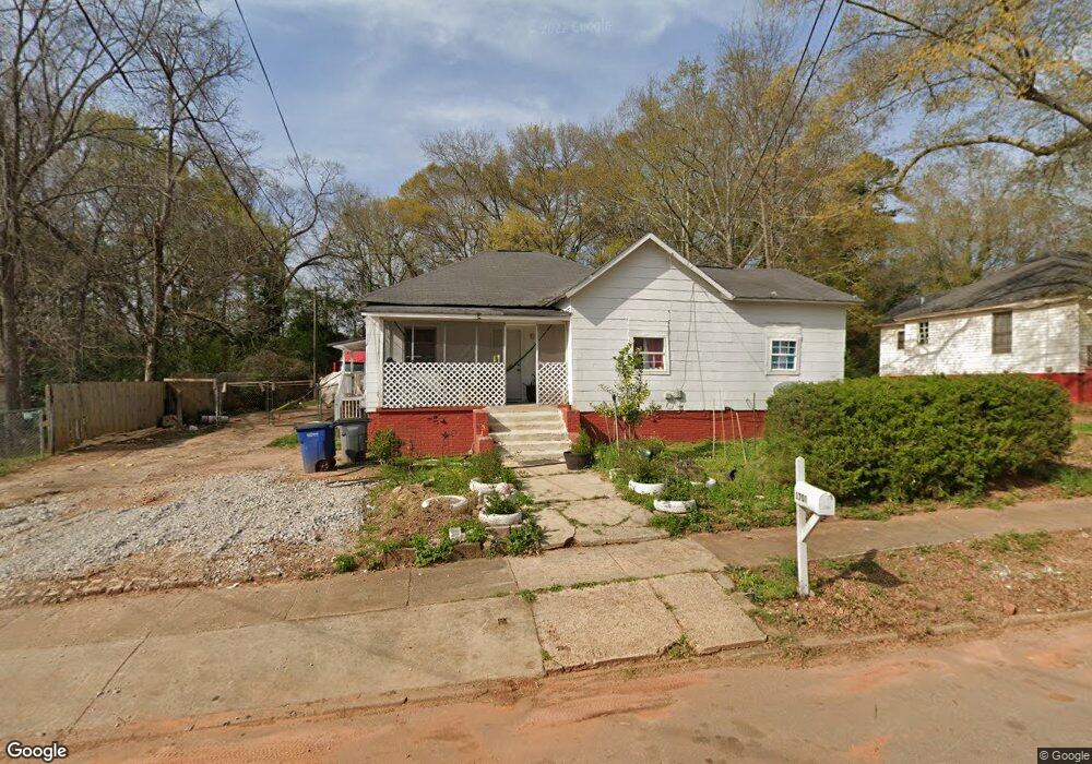
1700 Brownwood Ave Lagrange, GA 30240
Estimated Value: $28,747 - $179,000
3
Beds
2
Baths
1,697
Sq Ft
$56/Sq Ft
Est. Value
About This Home
This home is located at 1700 Brownwood Ave, Lagrange, GA 30240 and is currently estimated at $95,437, approximately $56 per square foot. 1700 Brownwood Ave is a home located in Troup County with nearby schools including Ethel W. Kight Elementary School, Hollis Hand Elementary School, and Franklin Forest Elementary School.
Ownership History
Date
Name
Owned For
Owner Type
Purchase Details
Closed on
Oct 2, 2017
Sold by
Whatley Susan B
Bought by
Orellana Fredy E
Current Estimated Value
Purchase Details
Closed on
Nov 18, 2003
Sold by
Flag Bank
Bought by
Whatley Susan B
Purchase Details
Closed on
Nov 13, 2003
Sold by
Julia Ann Thompson
Bought by
Flag Bank
Purchase Details
Closed on
Jul 1, 2003
Sold by
Helen Louise Baker
Bought by
Julia Ann Thompson
Purchase Details
Closed on
Dec 20, 1989
Bought by
Helen Louise Baker
Purchase Details
Closed on
Jul 1, 1988
Purchase Details
Closed on
Jun 27, 1977
Purchase Details
Closed on
Jan 1, 1949
Create a Home Valuation Report for This Property
The Home Valuation Report is an in-depth analysis detailing your home's value as well as a comparison with similar homes in the area
Home Values in the Area
Average Home Value in this Area
Purchase History
| Date | Buyer | Sale Price | Title Company |
|---|---|---|---|
| Orellana Fredy E | $15,000 | -- | |
| Whatley Susan B | $25,600 | -- | |
| Flag Bank | $25,000 | -- | |
| Julia Ann Thompson | $25,000 | -- | |
| Helen Louise Baker | -- | -- | |
| -- | $42,200 | -- | |
| -- | -- | -- | |
| -- | -- | -- |
Source: Public Records
Tax History Compared to Growth
Tax History
| Year | Tax Paid | Tax Assessment Tax Assessment Total Assessment is a certain percentage of the fair market value that is determined by local assessors to be the total taxable value of land and additions on the property. | Land | Improvement |
|---|---|---|---|---|
| 2024 | $665 | $24,400 | $3,280 | $21,120 |
| 2023 | $631 | $23,120 | $3,280 | $19,840 |
| 2022 | $614 | $22,000 | $3,280 | $18,720 |
| 2021 | $573 | $19,000 | $3,280 | $15,720 |
| 2020 | $573 | $19,000 | $3,280 | $15,720 |
| 2019 | $514 | $17,040 | $3,280 | $13,760 |
| 2018 | $508 | $16,840 | $3,280 | $13,560 |
| 2017 | $508 | $16,832 | $3,272 | $13,560 |
| 2016 | $497 | $16,491 | $3,272 | $13,219 |
| 2015 | $498 | $16,491 | $3,272 | $13,219 |
| 2014 | $495 | $16,359 | $3,272 | $13,087 |
| 2013 | -- | $17,491 | $3,272 | $14,219 |
Source: Public Records
Map
Nearby Homes
- 802 Monroe St
- 102 Crown St Unit LOT 1
- The Rhodes Plan at Crown Street Cottages
- The Truitt Plan at Crown Street Cottages
- The Callaway Plan at Crown Street Cottages
- 101 Crown St Unit LOT 5
- 608 Wilburn Ave
- 610 Wilburn Ave
- 202 Parker Ln
- 109 Garfield St
- 102 Parker St
- 612 S Lee St
- 205 Grady St
- 107 Clark St
- 119 Jones St
- 701 Jefferson St
- 211 Moores Hill
- 0 Moores Hill
- 507 S Lee St
- 167 S Kight Dr
- 1610 Brownwood Ave
- 1702 Brownwood Ave
- 1608 Brownwood Ave
- 1704 Brownwood Ave
- 800 Houston St
- 801 Troup St
- 1606 Brownwood Ave
- 803 Troup St
- 1706 Brownwood Ave
- 709 Jenkins St Unit 143
- 709 Jenkins St
- 802 Houston St
- 801 Houston St
- 805 Troup St
- 1604 Brownwood Ave
- 804 Houston St
- 803 Houston St
- 800 Troup St
- 703 Freeman St
- 807 Troup St