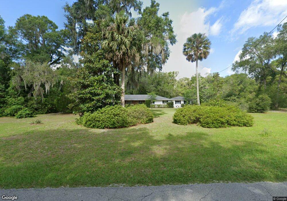
1700 N Stone St Deland, FL 32720
North DeLand NeighborhoodEstimated Value: $466,000 - $478,570
3
Beds
2
Baths
2,325
Sq Ft
$202/Sq Ft
Est. Value
About This Home
This home is located at 1700 N Stone St, Deland, FL 32720 and is currently estimated at $470,393, approximately $202 per square foot. 1700 N Stone St is a home located in Volusia County with nearby schools including Citrus Grove Elementary, Deland High School, and Deland Middle School.
Ownership History
Date
Name
Owned For
Owner Type
Purchase Details
Closed on
Jun 8, 2010
Sold by
Culpepper Morris P
Bought by
Culpepper Morris P and Morris P Culpepper Iii Revocable Trust
Current Estimated Value
Purchase Details
Closed on
May 19, 2009
Sold by
Culpepper Thelma D
Bought by
Culpepper Morris P
Purchase Details
Closed on
Mar 14, 2001
Sold by
Culpepper Morris P and Culpepper Thelma D
Bought by
Culpepper Morris P and Culpepper Thelma D
Create a Home Valuation Report for This Property
The Home Valuation Report is an in-depth analysis detailing your home's value as well as a comparison with similar homes in the area
Home Values in the Area
Average Home Value in this Area
Purchase History
| Date | Buyer | Sale Price | Title Company |
|---|---|---|---|
| Culpepper Morris P | -- | Attorney | |
| Culpepper Morris P | -- | Attorney | |
| Culpepper Morris P | -- | -- |
Source: Public Records
Tax History Compared to Growth
Tax History
| Year | Tax Paid | Tax Assessment Tax Assessment Total Assessment is a certain percentage of the fair market value that is determined by local assessors to be the total taxable value of land and additions on the property. | Land | Improvement |
|---|---|---|---|---|
| 2025 | $2,857 | $193,758 | -- | -- |
| 2024 | $2,857 | $188,298 | -- | -- |
| 2023 | $2,857 | $182,814 | $0 | $0 |
| 2022 | $2,795 | $177,489 | $0 | $0 |
| 2021 | $2,890 | $172,319 | $0 | $0 |
| 2020 | $2,846 | $169,940 | $0 | $0 |
| 2019 | $2,932 | $166,119 | $0 | $0 |
| 2018 | $2,921 | $163,022 | $0 | $0 |
| 2017 | $2,920 | $159,669 | $0 | $0 |
| 2016 | $2,788 | $156,385 | $0 | $0 |
| 2015 | $2,842 | $155,298 | $0 | $0 |
| 2014 | $2,813 | $154,065 | $0 | $0 |
Source: Public Records
Map
Nearby Homes
- 580 Mercers Fernery Rd
- 865 Asterfield Ln
- 882 Asterfield Ln
- 887 Asterfield Ln
- 897 Honey Petal Ln
- 903 Honey Petal Ln
- 2285 Wilmhurst Rd
- 0 Greens Dairy Rd Unit 1216610
- 0 Vacant Land Unit MFRA4667659
- 0 Vacant Land Unit MFRGC533353
- 1937 N Spring Garden Ave
- 425 Mercers Fernery Rd
- 305 Violetwood Rd
- 975 Rolling Acres Dr
- 1110 Mercers Fernery Rd
- 2172 N Spring Garden Ave
- 2200 N Clara Ave
- 260 Mercers Fernery Rd
- 1221 Bramley Ln
- 1224 Bexley Ct
- 1703 N Stone St
- 1705 N Stone St
- 1701 N Stone St
- 1710 Pollard Grove Dr
- 1707 N Stone St
- 1686 N Stone St
- 1710 N Stone St
- 687 Violetwood Rd
- 1715 Miller Dr
- 1716 N Stone St
- 1682 N Stone St
- 671 Violetwood Rd
- 1711 N Stone St
- 1705 Miller Dr
- 1710 Miller Dr
- 1722 N Stone St
- 645 Violetwood Rd
- 1687 Miller Dr
- 1741 Pollard Grove Dr