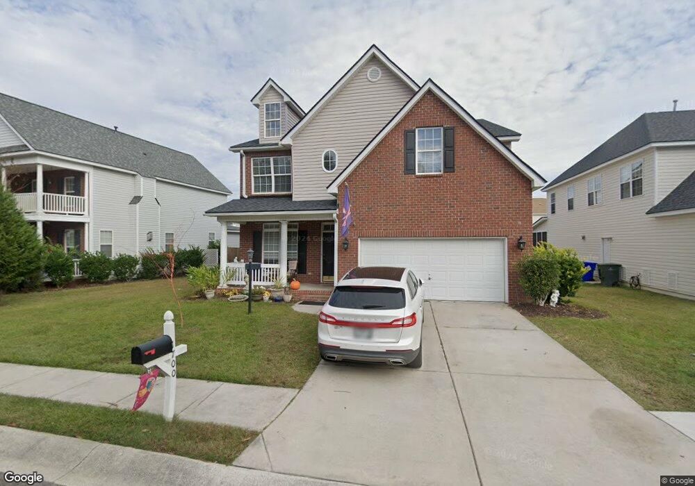
1700 Wayah Dr Charleston, SC 29414
West Ashley NeighborhoodEstimated Value: $543,000 - $622,000
4
Beds
3
Baths
3,262
Sq Ft
$179/Sq Ft
Est. Value
About This Home
This home is located at 1700 Wayah Dr, Charleston, SC 29414 and is currently estimated at $583,046, approximately $178 per square foot. 1700 Wayah Dr is a home located in Charleston County with nearby schools including Springfield Elementary School, West Ashley High School, and Carolina Voyager Charter.
Ownership History
Date
Name
Owned For
Owner Type
Purchase Details
Closed on
Aug 7, 2021
Sold by
Catherine Anderson
Bought by
Hopkins Allison and Hopkins Harold
Current Estimated Value
Home Financials for this Owner
Home Financials are based on the most recent Mortgage that was taken out on this home.
Original Mortgage
$368,533
Outstanding Balance
$334,606
Interest Rate
2.8%
Mortgage Type
New Conventional
Estimated Equity
$248,440
Purchase Details
Closed on
Jul 12, 2007
Sold by
Sims Wayne V
Bought by
Anderson Catherine
Home Financials for this Owner
Home Financials are based on the most recent Mortgage that was taken out on this home.
Original Mortgage
$157,000
Interest Rate
6.71%
Mortgage Type
Unknown
Purchase Details
Closed on
Jul 3, 2003
Sold by
Whipple Development Corp
Bought by
Sims Wayne and Sims Gayle M
Create a Home Valuation Report for This Property
The Home Valuation Report is an in-depth analysis detailing your home's value as well as a comparison with similar homes in the area
Home Values in the Area
Average Home Value in this Area
Purchase History
| Date | Buyer | Sale Price | Title Company |
|---|---|---|---|
| Hopkins Allison | $387,930 | None Listed On Document | |
| Anderson Catherine | $270,000 | None Available | |
| Sims Wayne | $247,000 | -- |
Source: Public Records
Mortgage History
| Date | Status | Borrower | Loan Amount |
|---|---|---|---|
| Open | Hopkins Allison | $368,533 | |
| Previous Owner | Anderson Catherine | $157,000 |
Source: Public Records
Tax History Compared to Growth
Tax History
| Year | Tax Paid | Tax Assessment Tax Assessment Total Assessment is a certain percentage of the fair market value that is determined by local assessors to be the total taxable value of land and additions on the property. | Land | Improvement |
|---|---|---|---|---|
| 2024 | $6,752 | $15,520 | $0 | $0 |
| 2023 | $6,752 | $23,280 | $0 | $0 |
| 2022 | $6,246 | $23,280 | $0 | $0 |
| 2021 | $5,210 | $19,600 | $0 | $0 |
| 2020 | $5,172 | $19,600 | $0 | $0 |
| 2019 | $4,730 | $17,050 | $0 | $0 |
| 2017 | $4,520 | $17,050 | $0 | $0 |
| 2016 | $4,374 | $17,050 | $0 | $0 |
| 2015 | $4,176 | $17,050 | $0 | $0 |
| 2014 | $3,593 | $0 | $0 | $0 |
| 2011 | -- | $0 | $0 | $0 |
Source: Public Records
Map
Nearby Homes
- 1701 Cranbrook Dr
- 2229 Rivermont Place
- 1395 Emerald Forest Pkwy
- 2106 Mission Ave
- 1784 Banbury Rd
- 2134 Egret Crest Ln Unit 2134
- 2224 Egret Crest Ln Unit 2224
- 1831 Egret Crest Ln Unit 1831
- 2522 Egret Crest Ln Unit 2522
- 2131 Forest Lakes Blvd
- 1647 Sulgrave Rd
- 1978 Planters Dr
- 114 Ashley Villa Cir Unit B
- 1938 Essex Farms Dr
- 2134 Vespers Dr
- 120 Ashley Villa Cir Unit A
- 1904 Treebark Dr
- 2515 Rutherford Way
- 109 Ashley Villa Cir Unit D
- 2416 Kendall Dr